Difference between revisions of "2013-12-31 34 -118"
imported>Bravissimo594 (→Location) |
imported>FippeBot m (Location) |
||
| (12 intermediate revisions by one other user not shown) | |||
| Line 24: | Line 24: | ||
<!-- who attended: If you link to your wiki user name in this section, your expedition will be picked up by the various statistics generated for geohashing. You may use three tildes ~ as a shortcut to automatically insert the user signature of the account you are editing with. | <!-- who attended: If you link to your wiki user name in this section, your expedition will be picked up by the various statistics generated for geohashing. You may use three tildes ~ as a shortcut to automatically insert the user signature of the account you are editing with. | ||
--> | --> | ||
| + | * [[User:Bravissimo594|Bravissimo594]] ([[User talk:Bravissimo594|talk]]) | ||
== Plans == | == Plans == | ||
<!-- what were the original plans --> | <!-- what were the original plans --> | ||
| + | "Plan" is a strong word for this one in the [[Los_Angeles,_California|Los Angeles]] graticule. I see that it is nearby to one possible route home, so I think I will stop by and see if it is accessible. | ||
== Expedition == | == Expedition == | ||
<!-- how it all turned out. your narrative goes here. --> | <!-- how it all turned out. your narrative goes here. --> | ||
| − | + | === [[User:Bravissimo594|Bravissimo594]] ([[User talk:Bravissimo594|talk]]) === | |
| − | == | + | I pulled up and parked in the street in front of the residence and then walked up the driveway to ask the people in the back house if they would mind my taking a picture in the driveway. No one was home, but to find that out, I had to walk through the hashpoint on my way to their door. So on the way out, I took a location fix and a couple of pictures. Success! |
| − | |||
== Photos == | == Photos == | ||
| Line 41: | Line 42: | ||
Image:2013-12-31_34_-118_11-37-59-570.jpg | Geohash Droid detail. [http://www.openstreetmap.org/?lat=34.06587068&lon=-118.07735795&zoom=16&layers=B000FTF @34.0659,-118.0774] | Image:2013-12-31_34_-118_11-37-59-570.jpg | Geohash Droid detail. [http://www.openstreetmap.org/?lat=34.06587068&lon=-118.07735795&zoom=16&layers=B000FTF @34.0659,-118.0774] | ||
| + | |||
| + | Image:2013-12-31_34_-118_16-09-03-727.jpg | The hash point. [http://www.openstreetmap.org/?lat=34.06600000&lon=-118.07700000&zoom=16&layers=B000FTF @34.0660,-118.0770] | ||
| + | |||
| + | Image:2013-12-31_34_-118_16-10-39-140.jpg | In the street in front of the residence. The point is up the driveway in the background. [http://www.openstreetmap.org/?lat=34.06600000&lon=-118.07700000&zoom=16&layers=B000FTF @34.0660,-118.0770] | ||
| + | |||
| + | Image:2013-12-31_34_-118_16-14-04-226.jpg | Vietnamese restaurant just down the street, but no time to stop and eat on this spontaneous drive-by geohashing expedition. [http://www.openstreetmap.org/?lat=34.06290000&lon=-118.07700000&zoom=16&layers=B000FTF @34.0629,-118.0770] | ||
</gallery> | </gallery> | ||
| Line 47: | Line 54: | ||
<!-- Add any achievement ribbons you earned below, or remove this section --> | <!-- Add any achievement ribbons you earned below, or remove this section --> | ||
| + | {{land geohash | ||
| + | | latitude = 34 | ||
| + | | longitude = -118 | ||
| + | | date = 2013-12-31 | ||
| + | | name = Bravissimo594 | ||
| + | <!-- | image = image name (optional) --> | ||
| + | |||
| + | }} | ||
<!-- =============== USEFUL CATEGORIES FOLLOW ================ | <!-- =============== USEFUL CATEGORIES FOLLOW ================ | ||
Delete the next line ONLY if you have chosen the appropriate categories below. If you are unsure, don't worry. People will read your report and help you with the classification. --> | Delete the next line ONLY if you have chosen the appropriate categories below. If you are unsure, don't worry. People will read your report and help you with the classification. --> | ||
| − | |||
<!-- Potential categories. Please include all the ones appropriate to your expedition --> | <!-- Potential categories. Please include all the ones appropriate to your expedition --> | ||
| Line 57: | Line 71: | ||
--> | --> | ||
| − | <!-- An actual expedition: | + | <!-- An actual expedition: --> |
[[Category:Expeditions]] | [[Category:Expeditions]] | ||
| − | |||
[[Category:Expeditions with photos]] | [[Category:Expeditions with photos]] | ||
| − | [[Category:Expeditions with videos]] | + | <!-- [[Category:Expeditions with videos]] |
| − | [[Category:Expedition without GPS]] | + | [[Category:Expedition without GPS]] --> |
| − | --> | ||
| − | <!-- if you reached your coords: | + | <!-- if you reached your coords: --> |
[[Category:Coordinates reached]] | [[Category:Coordinates reached]] | ||
| − | + | <!-- or if you failed :( | |
[[Category:Coordinates not reached]] | [[Category:Coordinates not reached]] | ||
-- and a reason -- | -- and a reason -- | ||
| Line 85: | Line 97: | ||
(Don't forget to delete this final close comment marker) --> | (Don't forget to delete this final close comment marker) --> | ||
| + | {{location|US|CA|LO}} | ||
Latest revision as of 05:03, 14 August 2019
| Tue 31 Dec 2013 in 34,-118: 34.0660378, -118.0768268 geohashing.info google osm bing/os kml crox |
Location
In the driveway of a duplex residence in Rosemead.
Participants
Plans
"Plan" is a strong word for this one in the Los Angeles graticule. I see that it is nearby to one possible route home, so I think I will stop by and see if it is accessible.
Expedition
Bravissimo594 (talk)
I pulled up and parked in the street in front of the residence and then walked up the driveway to ask the people in the back house if they would mind my taking a picture in the driveway. No one was home, but to find that out, I had to walk through the hashpoint on my way to their door. So on the way out, I took a location fix and a couple of pictures. Success!
Photos
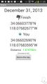
Geohash Droid detail. @34.0659,-118.0774
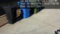
The hash point. @34.0660,-118.0770
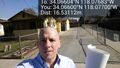
In the street in front of the residence. The point is up the driveway in the background. @34.0660,-118.0770
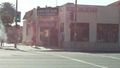
Vietnamese restaurant just down the street, but no time to stop and eat on this spontaneous drive-by geohashing expedition. @34.0629,-118.0770


Achievements
Bravissimo594 earned the Land geohash achievement
|