Difference between revisions of "2014-01-08 47 8"
imported>Calamus (Created page with "{{subst:Expedition|date=2014-01-08|lat=47|lon=8}}") |
imported>FippeBot m (Location) |
||
| (13 intermediate revisions by 3 users not shown) | |||
| Line 1: | Line 1: | ||
| − | + | [[Image:{{{image|2014-01-08 47 8 gardens.jpg}}}|thumb|left]] | |
| − | |||
| − | |||
| − | [[Image:{{{image| | ||
| − | |||
| − | |||
| − | |||
| − | |||
| − | |||
| − | |||
{{meetup graticule | {{meetup graticule | ||
| lat=47 | | lat=47 | ||
| Line 15: | Line 6: | ||
}} | }} | ||
| − | |||
__NOTOC__ | __NOTOC__ | ||
== Location == | == Location == | ||
| − | + | An allotment in Zurich's Höngg district. | |
== Participants == | == Participants == | ||
| − | + | [[User:Calamus|Calamus]], [[User:Chris_47_8|Chris_47_8]], [[User:Guga2112|Guga2112]] | |
| − | |||
== Plans == | == Plans == | ||
| − | + | ===Calamus=== | |
| + | # S9 train to Hardbrücke, leaving Zurich 41/42 at 12.04am | ||
| + | # 72 bus to Bucheggplatz | ||
| + | # 69 bus to Weidbadstrasse | ||
| + | # Arrive at 12.21 and see if the allotments are freely accessible | ||
| + | |||
| + | ===Guga2112=== | ||
| + | I'll be just jogging there after the sunset, no special plans, no exact times. I'm sorry I just saw your plans, but anyway I couldn't be there since I'm currently at work --[[User:Guga2112|Guga2112]] ([[User talk:Guga2112|talk]]) 07:15, 8 January 2014 (EST) | ||
== Expedition == | == Expedition == | ||
| − | + | ===Calamus and Chris=== | |
| + | For the last few months, Calamus had been very busy. In fact, he was very busy even today. But since all work and no play made him a dull boy, and not leaving the office building for several days had started to affect Calamus's skin tone in a way that couldn't possibly be anywhere near healthy, he decided to go for a hashpoint. | ||
| + | |||
| + | Most fortunately, the point lay directly in Zurich, and even in one of the places best suited for a casual stroll: The ''Waid'', a wooded hillside in the district of Höngg. To be exact, it lay on the walkway between some allotment gardens, where elderly, wealthy Zurichois spent their time growing vegetables before turning into one themselves. | ||
| + | |||
| + | Arriving on the ''Waid'', Calamus was baffled by the wonderful panorama of the city, the lake and Glarnese Alps in the distance. Was the view even more beautiful than usual or did he just need to get out more? Either way, the hashpoint was inside the garden area, which was of course fenced in. Calamus had originally hoped to maybe find somebody who could open the gate for him, but he didn't spot anyone. So he decided to wait for Chris to at least fail together. After Chris hadn't arrived for some time, Calamus shrugged and turned to leave. When he was already on his way back down the hill, he heard a whistle behind himself. Chris had been held up, but had arrived at last. And unlike Calamus, he had found a garden owner inside the area. | ||
| + | |||
| + | Calamus began to devise a plan. It wasn't going to be easy to convince an allotment gardener to open a gate for two strangers without a very good reason, not even with the authority of the Internet. After all, the collocation ''wi d'shrebrgäärtnr z'Höngg'' ("like the allotment gardeners in Höngg") was used to refer to very scrupulous and stubborn people. But with a believable story and an ample dialogue tree they might – "Hey there! Could you open this gate?", Chris called. "Sure thing", the garden owner replied, "I'll just leave it unlocked so you won't have any trouble on your way out." And they were inside. | ||
| + | |||
| + | The hashpoint was indeed exactly on the pathway (or so said Chris's device – Calamus's advised them to step into the meticulously tilled soil, but … Chris's device was probably more accurate). A picture was taken, and the two of them parted ways once more. | ||
| + | |||
| + | ===Guga2112=== | ||
| + | I came back home from work at around 5pm. I already intended to jog 6km today, and when I saw the Geohash was exactly 2.9km from my home I thought to myself, hey, why not. The only problem is that these 2.9km were EXTREMELY STEEP. However, I thought a little bit of jogging uphill would be a nice training, so I put on my gear and left. | ||
| + | |||
| + | After 18 minutes where I was pondering how overrated breathing is, I approached the hashpoint and slowed down. It was extremely dark and I couldn't see the paths that brought to the hash. Then I noticed it: the dreaded fence. Nobody was there to help me, it was too late and even if there were anybody I hardly think I would have been able to explain what I was trying to do in German. So I went to the nearest publicly accessible point (48m away, according to my GPS) and took a nice picture of Zurich by night seen by the Hönggerberg mountain. Taking night pictures with a mobile phone isn't anyway that easy. | ||
| + | |||
| + | Coming back home, instead, was a piece of cake. 3kms of downhill jog, my knees and ankles still hurt, but hey, at least I was able to break my personal pace record :D | ||
== Tracklog == | == Tracklog == | ||
| − | + | Calamus: [http://www.everytrail.com/view_trip.php?trip_id=2556966 On EveryTrail] | |
== Photos == | == Photos == | ||
| − | < | + | <gallery perrow="4"> |
| − | Image: | + | Image:2014-01-08 47 8 gardens.jpg | The plots |
| − | -- | + | Image:2014-01-08 47 8 hash.jpg | The hashpoint |
| − | + | Image:2014-01-08 47 8 hashview.jpg | View from the hashpoint | |
| + | Image:2014-01-08 47 8 deers.jpg | Some wayside deer | ||
| + | Image:2014-01-08 47 8 zurich.jpg | Daytime view from Hönggerberg | ||
| + | Image:2014-01-08_47_8_08-47-46-609.jpg | Nighttime view from Hönggerberg | ||
</gallery> | </gallery> | ||
| − | == | + | ===Chris=== |
| − | |||
| − | |||
| + | <gallery perrow="4"> | ||
| + | Image:2014-01-08_47_8-CH01.PNG | Proof 1 | ||
| + | Image:2014-01-08_47_8-CH02.PNG | Proof 2 | ||
| + | Image:2014-01-08_47_8-CH03.JPG | Calamus and Chris | ||
| + | Image:2014-01-08_47_8-CH04.JPG | A hedgehog and some garden gnomes | ||
| + | Image:2014-01-08_47_8-CH06.JPG | Panoramic view (large) | ||
| + | Image:2014-01-08_47_8-CH07.JPG | The mountains, the lake, the city. | ||
| + | </gallery> | ||
| − | |||
| − | |||
| − | |||
| − | + | == Achievements == | |
| − | + | {{#vardefine:ribbonwidth|800px}} | |
| − | [[ | + | {{Ambassador geohash|latitude=47|longitude=8|date=2014-01-08|granter=an allotment owner|name = [[User:Calamus|Calamus]] and [[User:Chris_47_8|Chris]]}} |
| − | -- | + | {{No trespassing |latitude=47 |longitude=8 |date=2014-01-08 |name= [[User:Guga2112|Guga2112]] |distance=48m }} |
| − | |||
[[Category:Expeditions]] | [[Category:Expeditions]] | ||
| − | |||
[[Category:Expeditions with photos]] | [[Category:Expeditions with photos]] | ||
| − | |||
| − | |||
| − | |||
| − | |||
| − | |||
[[Category:Coordinates reached]] | [[Category:Coordinates reached]] | ||
| − | + | {{location|CH|ZH}} | |
| − | |||
| − | |||
| − | |||
| − | |||
| − | |||
| − | |||
| − | |||
| − | |||
| − | |||
| − | |||
| − | |||
| − | |||
| − | |||
| − | |||
| − | |||
| − | |||
| − | |||
Latest revision as of 05:10, 14 August 2019

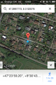
| Wed 8 Jan 2014 in 47,8: 47.3997770, 8.5120076 geohashing.info google osm bing/os kml crox |
Location
An allotment in Zurich's Höngg district.
Participants
Plans
Calamus
- S9 train to Hardbrücke, leaving Zurich 41/42 at 12.04am
- 72 bus to Bucheggplatz
- 69 bus to Weidbadstrasse
- Arrive at 12.21 and see if the allotments are freely accessible
Guga2112
I'll be just jogging there after the sunset, no special plans, no exact times. I'm sorry I just saw your plans, but anyway I couldn't be there since I'm currently at work --Guga2112 (talk) 07:15, 8 January 2014 (EST)
Expedition
Calamus and Chris
For the last few months, Calamus had been very busy. In fact, he was very busy even today. But since all work and no play made him a dull boy, and not leaving the office building for several days had started to affect Calamus's skin tone in a way that couldn't possibly be anywhere near healthy, he decided to go for a hashpoint.
Most fortunately, the point lay directly in Zurich, and even in one of the places best suited for a casual stroll: The Waid, a wooded hillside in the district of Höngg. To be exact, it lay on the walkway between some allotment gardens, where elderly, wealthy Zurichois spent their time growing vegetables before turning into one themselves.
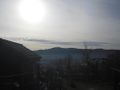
Arriving on the Waid, Calamus was baffled by the wonderful panorama of the city, the lake and Glarnese Alps in the distance. Was the view even more beautiful than usual or did he just need to get out more? Either way, the hashpoint was inside the garden area, which was of course fenced in. Calamus had originally hoped to maybe find somebody who could open the gate for him, but he didn't spot anyone. So he decided to wait for Chris to at least fail together. After Chris hadn't arrived for some time, Calamus shrugged and turned to leave. When he was already on his way back down the hill, he heard a whistle behind himself. Chris had been held up, but had arrived at last. And unlike Calamus, he had found a garden owner inside the area.
Calamus began to devise a plan. It wasn't going to be easy to convince an allotment gardener to open a gate for two strangers without a very good reason, not even with the authority of the Internet. After all, the collocation wi d'shrebrgäärtnr z'Höngg ("like the allotment gardeners in Höngg") was used to refer to very scrupulous and stubborn people. But with a believable story and an ample dialogue tree they might – "Hey there! Could you open this gate?", Chris called. "Sure thing", the garden owner replied, "I'll just leave it unlocked so you won't have any trouble on your way out." And they were inside.
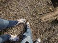
The hashpoint was indeed exactly on the pathway (or so said Chris's device – Calamus's advised them to step into the meticulously tilled soil, but … Chris's device was probably more accurate). A picture was taken, and the two of them parted ways once more.
Guga2112
I came back home from work at around 5pm. I already intended to jog 6km today, and when I saw the Geohash was exactly 2.9km from my home I thought to myself, hey, why not. The only problem is that these 2.9km were EXTREMELY STEEP. However, I thought a little bit of jogging uphill would be a nice training, so I put on my gear and left.
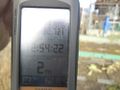
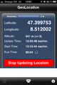
After 18 minutes where I was pondering how overrated breathing is, I approached the hashpoint and slowed down. It was extremely dark and I couldn't see the paths that brought to the hash. Then I noticed it: the dreaded fence. Nobody was there to help me, it was too late and even if there were anybody I hardly think I would have been able to explain what I was trying to do in German. So I went to the nearest publicly accessible point (48m away, according to my GPS) and took a nice picture of Zurich by night seen by the Hönggerberg mountain. Taking night pictures with a mobile phone isn't anyway that easy.
Coming back home, instead, was a piece of cake. 3kms of downhill jog, my knees and ankles still hurt, but hey, at least I was able to break my personal pace record :D
Tracklog
Calamus: On EveryTrail
Photos
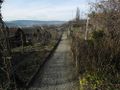
The plots
The hashpoint
View from the hashpoint
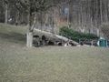
Some wayside deer
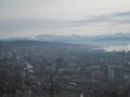
Daytime view from Hönggerberg
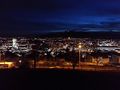
Nighttime view from Hönggerberg


Chris
Proof 1
Proof 2
Calamus and Chris
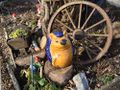
A hedgehog and some garden gnomes
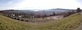
Panoramic view (large)
The mountains, the lake, the city.


Achievements
Calamus and Chris earned the Ambassador achievement
|
Guga2112 earned the No trespassing consolation prize
|