Difference between revisions of "2014-01-15 50 8"
imported>Mampfred (Created page with "{{subst:Expedition |lat = 50 |lon = 8 |date = 2014-01-15 }}") |
imported>FippeBot m (Location) |
||
| (7 intermediate revisions by 3 users not shown) | |||
| Line 1: | Line 1: | ||
| − | |||
| − | |||
| − | |||
| − | |||
| − | |||
| − | |||
| − | |||
| − | |||
| − | |||
| − | |||
{{meetup graticule | {{meetup graticule | ||
| lat=50 | | lat=50 | ||
| Line 15: | Line 5: | ||
}} | }} | ||
| − | |||
__NOTOC__ | __NOTOC__ | ||
== Location == | == Location == | ||
| − | + | A field in Bad Vilbel. Probably wet. Most certainly wet. Very wet in fact. | |
== Participants == | == Participants == | ||
| − | + | * [[User:Rincewind|Rincewind]] | |
| − | + | * [[User:Mampfred|Mampfred]] | |
== Plans == | == Plans == | ||
| − | + | First meetup in 2014 and it's about time. Mampfred will ride in on the ICE from Erfurt and Rincewind will ride his trusty (motorized) Steed from Darmstadt. There's even a pub (well, restaurant) not far from the hash so we'll see what happens ... | |
| + | |||
| + | Eta around 20:45 if anyone wants to join us. | ||
== Expedition == | == Expedition == | ||
| − | + | Success. We met at Bad Vilbel train station and a short drive and a short walk later the hash was ours. We also went to the restaurant as planned which was probably visible from the hash (no confirmation due to darkness hashing). | |
| + | |||
| + | Will post pics later as there seems to be a problem selecting images from the gallery with geohash droid on the Nexus 5. | ||
== Tracklog == | == Tracklog == | ||
| − | + | Not this time. | |
== Photos == | == Photos == | ||
| − | |||
| − | |||
| − | |||
<gallery perrow="5"> | <gallery perrow="5"> | ||
| + | Image:2014-01-15_50_8_hashers.jpg | Dark it was - as usual | ||
| + | Image:2014-01-15_50_8_gpsproof.jpg | Duh, completely forgot to upload this. Sorry, mate. | ||
</gallery> | </gallery> | ||
| Line 45: | Line 37: | ||
| − | |||
| − | |||
| − | |||
| − | |||
| − | |||
| − | |||
| − | |||
| − | |||
| − | |||
| − | |||
[[Category:Expeditions]] | [[Category:Expeditions]] | ||
| − | |||
[[Category:Expeditions with photos]] | [[Category:Expeditions with photos]] | ||
| − | |||
| − | |||
| − | |||
| − | |||
| − | |||
[[Category:Coordinates reached]] | [[Category:Coordinates reached]] | ||
| − | + | {{location|DE|HE|FB}} | |
| − | |||
| − | |||
| − | |||
| − | |||
| − | |||
| − | |||
| − | |||
| − | |||
| − | |||
| − | |||
| − | |||
| − | |||
| − | |||
| − | |||
| − | |||
| − | |||
| − | |||
Latest revision as of 05:14, 14 August 2019
| Wed 15 Jan 2014 in 50,8: 50.1840902, 8.7179495 geohashing.info google osm bing/os kml crox |
Location
A field in Bad Vilbel. Probably wet. Most certainly wet. Very wet in fact.
Participants
Plans
First meetup in 2014 and it's about time. Mampfred will ride in on the ICE from Erfurt and Rincewind will ride his trusty (motorized) Steed from Darmstadt. There's even a pub (well, restaurant) not far from the hash so we'll see what happens ...
Eta around 20:45 if anyone wants to join us.
Expedition
Success. We met at Bad Vilbel train station and a short drive and a short walk later the hash was ours. We also went to the restaurant as planned which was probably visible from the hash (no confirmation due to darkness hashing).
Will post pics later as there seems to be a problem selecting images from the gallery with geohash droid on the Nexus 5.
Tracklog
Not this time.
Photos
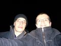
Dark it was - as usual
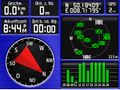
Duh, completely forgot to upload this. Sorry, mate.

