Difference between revisions of "2014-04-09 50 -114"
From Geohashing
imported>Guzzby (→Expedition) |
m (More specific location) |
||
| (11 intermediate revisions by 3 users not shown) | |||
| Line 36: | Line 36: | ||
Could only get to within 290 meters of the hash point. | Could only get to within 290 meters of the hash point. | ||
Destination is on private property. | Destination is on private property. | ||
| − | Found 3 of the 4 geocaches | + | Found 3 of the 4 geocaches I planned on finding. |
| − | |||
| − | |||
| − | |||
== Photos == | == Photos == | ||
| Line 46: | Line 43: | ||
--> | --> | ||
<gallery perrow="5"> | <gallery perrow="5"> | ||
| + | Image:2014-04-09_50_-114_guzzby1.jpg | I think the horses are on the geohash. | ||
| + | Image:2014-04-09_50_-114_guzzby2.jpg | View from first cache site. | ||
| + | Image:2014-04-09_50_-114_guzzby3.jpg | Trail leading to first cache site. | ||
| + | Image:2014-04-09_50_-114_guzzby4.jpg | Now where is that micro container? | ||
</gallery> | </gallery> | ||
| Line 51: | Line 52: | ||
{{#vardefine:ribbonwidth|800px}} | {{#vardefine:ribbonwidth|800px}} | ||
<!-- Add any achievement ribbons you earned below, or remove this section --> | <!-- Add any achievement ribbons you earned below, or remove this section --> | ||
| + | {{#vardefine:ribbonwidth|800px}} | ||
| + | {{No trespassing | latitude = 50 | longitude = -114 | date = 2014-04-09 | name = Guzzby | distance = 290m}} | ||
| − | |||
| − | |||
| − | |||
| − | |||
| − | |||
| − | |||
| − | |||
| − | |||
| − | |||
| − | |||
| − | |||
| − | |||
| − | |||
[[Category:Expeditions]] | [[Category:Expeditions]] | ||
| − | |||
[[Category:Expeditions with photos]] | [[Category:Expeditions with photos]] | ||
| − | |||
| − | |||
| − | |||
| − | |||
| − | |||
| − | |||
| − | |||
| − | |||
| − | |||
[[Category:Coordinates not reached]] | [[Category:Coordinates not reached]] | ||
| − | -- | + | <!-- When there is a man-made obstacle between you and the target: --> |
| − | |||
| − | |||
| − | |||
| − | When there is a man-made obstacle between you and the target: | ||
[[Category:Not reached - No public access]] | [[Category:Not reached - No public access]] | ||
| − | + | {{location|CA|AB|FH}} | |
| − | |||
| − | |||
| − | |||
| − | |||
| − | |||
| − | |||
| − | |||
Latest revision as of 00:06, 10 August 2020
| Wed 9 Apr 2014 in 50,-114: 50.6561238, -114.0983658 geohashing.info google osm bing/os kml crox |
Location
6 Km Southwest of Okotoks, AB Near Township Rd 200 and Range Road 14
Participants
Plans
Plan on driving out to the hash point around 1:00 pm. Take some pictures of the farmers field and pick up 4 geocaches in the vicinity.
Expedition
Arrived around 1:30 pm. Took some pictures. Could only get to within 290 meters of the hash point. Destination is on private property. Found 3 of the 4 geocaches I planned on finding.
Photos
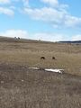
I think the horses are on the geohash.
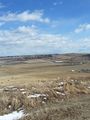
View from first cache site.
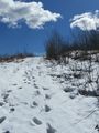
Trail leading to first cache site.
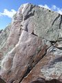
Now where is that micro container?


Achievements
Guzzby earned the No trespassing consolation prize
|