Difference between revisions of "2014-05-12 49 8"
imported>Q-Owl (image at the top (left)) |
imported>FippeBot m (Location) |
||
| (3 intermediate revisions by one other user not shown) | |||
| Line 30: | Line 30: | ||
It was a little detour on my way home after ending with work a little bit earlier. | It was a little detour on my way home after ending with work a little bit earlier. | ||
| − | I drove to Hochstädten, parked the car and had to | + | I drove to Hochstädten, parked the car and had to find the path into the wood. After crossing a farmyard opposite to the "Fiesta" restaurant, I saw the path and went up into the wood until I reached the blind end of the path after 5 or 10 minutes. |
About 30 m above this place I tried to find the exact coordinates. A GPS dance on a >45° slope is not very easy and with trees and dark clouds over you. ...^^ But it's possible: Success. :-) | About 30 m above this place I tried to find the exact coordinates. A GPS dance on a >45° slope is not very easy and with trees and dark clouds over you. ...^^ But it's possible: Success. :-) | ||
I found and marked the place, took some fotos and went/drove home. :-)) | I found and marked the place, took some fotos and went/drove home. :-)) | ||
| + | |||
| + | To visit a hashpoint was the requirement for the [http://flopp.net/safari safari geocache] [http://opencaching.de/OCF495 OCF495]. | ||
== Photos == | == Photos == | ||
| Line 57: | Line 59: | ||
== Achievements / Honorable Mention == | == Achievements / Honorable Mention == | ||
| − | {{#vardefine:ribbonwidth| | + | {{#vardefine:ribbonwidth|700px}} |
{{land geohash | {{land geohash | ||
| latitude = 49 | | latitude = 49 | ||
| Line 64: | Line 66: | ||
| name = Q-Owl | | name = Q-Owl | ||
}} | }} | ||
| + | {{Hash collision | latitude = 49 | longitude = 8 | date = 2014-05-12 | name = Q-Owl | | ||
| + | id = OCF495 | link = http://opencaching.de/OCF495 | | ||
| + | distance = 0.0 km }} geocache solved by visiting the hashpoint. | ||
| + | |||
<!-- =============== USEFUL CATEGORIES FOLLOW ================ --> | <!-- =============== USEFUL CATEGORIES FOLLOW ================ --> | ||
| Line 79: | Line 85: | ||
[[Category:Coordinates reached]] | [[Category:Coordinates reached]] | ||
[[Category:Expeditions with photos]] | [[Category:Expeditions with photos]] | ||
| + | {{location|DE|HE|HP}} | ||
Latest revision as of 06:31, 14 August 2019

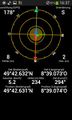
| Mon 12 May 2014 in 49,8: 49.7105412, 8.6512221 geohashing.info google osm bing/os kml crox |
Location
In the wood near Bensheim-Auerbach, the northern part of Bensheim, above the area of the fire brigade Hochstädten.
Participants
Plan
Drive to Hochstädten (in the east of Bensheim-Auerbach) after Work about 16:10. There might be a little footpath starting opposite to the "Fiesta" Restaurant and leading near the hashpoint.
Expedition
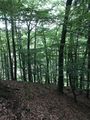
It was a little detour on my way home after ending with work a little bit earlier. I drove to Hochstädten, parked the car and had to find the path into the wood. After crossing a farmyard opposite to the "Fiesta" restaurant, I saw the path and went up into the wood until I reached the blind end of the path after 5 or 10 minutes.
About 30 m above this place I tried to find the exact coordinates. A GPS dance on a >45° slope is not very easy and with trees and dark clouds over you. ...^^ But it's possible: Success. :-)
I found and marked the place, took some fotos and went/drove home. :-))
To visit a hashpoint was the requirement for the safari geocache OCF495.
Photos
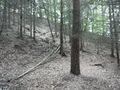
HP in the wood above the fire brigade

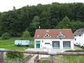
The "Fiesta" restaurant
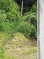
The path from a farm yard up into the wood
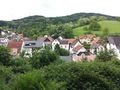
View over the Village from the wood
End of the path
Proof
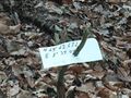
Mark

Grin
View to NW from the hash


Achievements / Honorable Mention
Q-Owl earned the Land geohash achievement
|
Q-Owl earned the Hash collision achievement
|
geocache solved by visiting the hashpoint.