Difference between revisions of "2014-05-12 50 8"
From Geohashing
imported>Yakamoz (→Expedition) |
imported>FippeBot m (Location) |
||
| (6 intermediate revisions by 2 users not shown) | |||
| Line 1: | Line 1: | ||
| − | |||
| − | |||
| − | |||
| − | |||
| − | |||
| − | |||
| − | |||
| − | |||
| − | |||
| − | |||
{{meetup graticule | {{meetup graticule | ||
| lat=50 | | lat=50 | ||
| Line 15: | Line 5: | ||
}} | }} | ||
| − | |||
__NOTOC__ | __NOTOC__ | ||
== Location == | == Location == | ||
| − | + | Between Giessen and Marburg, near the federal road B3. | |
| − | Between Giessen and Marburg, | ||
== Participants == | == Participants == | ||
| − | |||
| − | |||
* [[User:Rincewind|Rincewind]] | * [[User:Rincewind|Rincewind]] | ||
* [[User:Yakamoz|Yakamoz]] | * [[User:Yakamoz|Yakamoz]] | ||
== Plans == | == Plans == | ||
| − | + | To use a sunny spell during April showers in May... | |
| − | To use | ||
== Expedition == | == Expedition == | ||
| − | This geohash was very easy to reach. We drove with Rincewinds car | + | This geohash was very easy to reach. We drove with Rincewinds car and walked 50 meters. The short trip was successful. |
== Tracklog == | == Tracklog == | ||
| Line 38: | Line 23: | ||
== Photos == | == Photos == | ||
| − | |||
| − | |||
| − | |||
<gallery perrow="5"> | <gallery perrow="5"> | ||
| − | + | Image:2014-05-12_50_8_Rincewind_1399908942292.jpg | Next to the geohash. A typical German Fachwerkhaus (a timbered house) | |
| − | Image:2014-05-12_50_8_Rincewind_1399908942292.jpg | Next to the geohash. A typical German Fachwerkhaus | ||
| − | |||
Image:2014-05-12_50_8_Rincewind_1399909153000.jpg | Coordinates reached | Image:2014-05-12_50_8_Rincewind_1399909153000.jpg | Coordinates reached | ||
| − | |||
Image:2014-05-12_50_8_Rincewind_1399909202686.jpg | Yay! | Image:2014-05-12_50_8_Rincewind_1399909202686.jpg | Yay! | ||
| − | |||
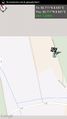
Image:2014-05-12_50_8_Rincewind_1399909284230.jpg | Geohash track | Image:2014-05-12_50_8_Rincewind_1399909284230.jpg | Geohash track | ||
</gallery> | </gallery> | ||
| Line 54: | Line 32: | ||
== Achievements == | == Achievements == | ||
{{#vardefine:ribbonwidth|800px}} | {{#vardefine:ribbonwidth|800px}} | ||
| − | |||
| − | |||
Land | Land | ||
| − | |||
| − | |||
| − | |||
| − | |||
| − | |||
| − | |||
| − | |||
| − | |||
| − | |||
| − | |||
| − | |||
| − | |||
| − | |||
[[Category:Expeditions]] | [[Category:Expeditions]] | ||
| − | |||
[[Category:Expeditions with photos]] | [[Category:Expeditions with photos]] | ||
| − | |||
| − | |||
| − | |||
| − | |||
| − | |||
[[Category:Coordinates reached]] | [[Category:Coordinates reached]] | ||
| − | + | {{location|DE|HE|MR}} | |
| − | |||
| − | |||
| − | |||
| − | |||
| − | |||
| − | |||
| − | |||
| − | |||
| − | |||
| − | |||
| − | |||
| − | |||
| − | |||
| − | |||
| − | |||
| − | |||
| − | |||
Latest revision as of 00:17, 7 August 2019
| Mon 12 May 2014 in 50,8: 50.7105412, 8.6512221 geohashing.info google osm bing/os kml crox |
Location
Between Giessen and Marburg, near the federal road B3.
Participants
Plans
To use a sunny spell during April showers in May...
Expedition
This geohash was very easy to reach. We drove with Rincewinds car and walked 50 meters. The short trip was successful.
Tracklog
Photos
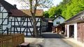
Next to the geohash. A typical German Fachwerkhaus (a timbered house)
Coordinates reached

Yay!
Geohash track


Achievements
Land