Difference between revisions of "2014-06-12 49 8"
imported>DODO (Create) |
imported>FippeBot m (Location) |
||
| (12 intermediate revisions by one other user not shown) | |||
| Line 18: | Line 18: | ||
__NOTOC__ | __NOTOC__ | ||
== Location == | == Location == | ||
| − | + | In a field south of Ketsch | |
== Participants == | == Participants == | ||
| − | + | [[User:DODO|DODO]] ([[User talk:DODO|talk]]) | |
| − | |||
== Plans == | == Plans == | ||
| − | + | I'm waiting for this for almost half a year: a hash on my way to work. And not on a weekend :-) | |
| + | So I'll go there tomorrow morning on my way to work and will be there around 8 o'clock (I'm going to row in the evening and can't go then). | ||
== Expedition == | == Expedition == | ||
<!-- how it all turned out. your narrative goes here. --> | <!-- how it all turned out. your narrative goes here. --> | ||
| + | That was an easy one, just one km detour from my usual ride to the office. The exact point was ten meters in a dense wheat field next to the [http://www.johanneshof.de Johanneshof], a popular restaurant destination. I walked some meters into the field but didn’t want to hashdance as I would have damaged too many plants. So I only reached 3m, but I’m absolutely fine with that. | ||
== Tracklog == | == Tracklog == | ||
<!-- if your GPS device keeps a log, you may post a link here --> | <!-- if your GPS device keeps a log, you may post a link here --> | ||
| + | [http://www.gpsies.com/map.do?fileId=yclbvlloazdhlagd bike: 17 KM (instead of 16)] | ||
== Photos == | == Photos == | ||
| Line 37: | Line 39: | ||
Image:2012-##-## ## ## Alpha.jpg | Witty Comment | Image:2012-##-## ## ## Alpha.jpg | Witty Comment | ||
--> | --> | ||
| − | <gallery perrow=" | + | <gallery perrow="6"> |
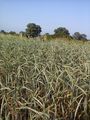
| + | Image:2014-06-12_49_8-1.jpg | wheat (10 m in there) | ||
| + | Image:2014-06-12_49_8-2.jpg | view to the Johanneshof | ||
| + | Image:2014-06-12_49_8-3.jpg | proof | ||
| + | Image:2014-06-12_49_8-4.jpg | my bull seen from the hashpoint | ||
| + | Image:2014-06-12_49_8-5.jpg | obligatory | ||
| + | Image:2014-06-12_49_8-6.jpg | I collected some limpets on my way into the field | ||
</gallery> | </gallery> | ||
| Line 43: | Line 51: | ||
{{#vardefine:ribbonwidth|800px}} | {{#vardefine:ribbonwidth|800px}} | ||
<!-- Add any achievement ribbons you earned below, or remove this section --> | <!-- Add any achievement ribbons you earned below, or remove this section --> | ||
| + | {{land geohash | ||
| + | | latitude = 49 | ||
| + | | longitude = 8 | ||
| + | | date = 2014-06-12 | ||
| + | | name = DODO | ||
| + | }} | ||
| − | |||
| − | |||
| − | |||
| − | |||
| − | |||
| − | |||
| − | |||
| − | |||
| − | |||
| − | |||
| − | |||
[[Category:Expeditions]] | [[Category:Expeditions]] | ||
| − | |||
[[Category:Expeditions with photos]] | [[Category:Expeditions with photos]] | ||
| − | |||
| − | |||
| − | |||
| − | |||
| − | |||
[[Category:Coordinates reached]] | [[Category:Coordinates reached]] | ||
| − | + | {{location|DE|BW|HD}} | |
| − | |||
| − | |||
| − | |||
| − | |||
| − | |||
| − | |||
| − | |||
| − | |||
| − | |||
| − | |||
| − | |||
| − | |||
| − | |||
| − | |||
| − | |||
| − | |||
| − | |||
Latest revision as of 06:51, 14 August 2019
| Thu 12 Jun 2014 in 49,8: 49.3533276, 8.5028548 geohashing.info google osm bing/os kml crox |
Location
In a field south of Ketsch
Participants
Plans
I'm waiting for this for almost half a year: a hash on my way to work. And not on a weekend :-) So I'll go there tomorrow morning on my way to work and will be there around 8 o'clock (I'm going to row in the evening and can't go then).
Expedition
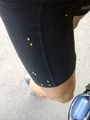
That was an easy one, just one km detour from my usual ride to the office. The exact point was ten meters in a dense wheat field next to the Johanneshof, a popular restaurant destination. I walked some meters into the field but didn’t want to hashdance as I would have damaged too many plants. So I only reached 3m, but I’m absolutely fine with that.
Tracklog
Photos
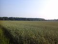
wheat (10 m in there)
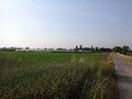
view to the Johanneshof
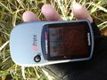
proof
my bull seen from the hashpoint

obligatory
I collected some limpets on my way into the field


Achievements
DODO earned the Land geohash achievement
|