Difference between revisions of "2014-06-25 51 9"
imported>GeorgDerReisende (new expedition to Hohengandern) |
imported>FippeBot m (Location) |
||
| (2 intermediate revisions by one other user not shown) | |||
| Line 1: | Line 1: | ||
| − | |||
| − | |||
| − | |||
| − | |||
| − | |||
| − | |||
| − | |||
| − | |||
| − | |||
| − | |||
{{meetup graticule | {{meetup graticule | ||
| lat=51 | | lat=51 | ||
| Line 18: | Line 8: | ||
__NOTOC__ | __NOTOC__ | ||
== Location == | == Location == | ||
| − | + | ||
| + | The hash lay on a meadow near Hohengandern. | ||
== Participants == | == Participants == | ||
| − | + | ||
| − | + | [[User:GeorgDerReisende|GeorgDerReisende]] | |
== Plans == | == Plans == | ||
| − | + | ||
| + | Hitchhiking. | ||
== Expedition == | == Expedition == | ||
| − | + | ||
| + | I started my expedition at 10:30, started to hitchhike at 11:30 and arrived with four cars at Eichenberg at 12:45. I walked zigzag through the countryside, looking for some geocaches, and arrived near the hash at 14:33. I found the hash not on the street, but some meters on the meadow. The meadow had a fence, electric wired. But at one place I found in fence one wire a bit higher then elsewhere. The reason might be the geocache behind the meadow, on the other side of the meadow was a similar hole. I crawled beyond the wire and found the hash on the field. I didn't go to the nearby geocache, because I couldn't find a trail to it. Afterwards I looked for more geocaches. I started to travel home from Hohengandern at 17:50 and arrived at Kassel at 19:04 with two cars. | ||
== Tracklog == | == Tracklog == | ||
| Line 38: | Line 31: | ||
--> | --> | ||
<gallery perrow="5"> | <gallery perrow="5"> | ||
| + | Image:2014-06-25 51 9 GeorgDerReisende 2608.jpg | [http://coord.info/GC41671] GC41671 | ||
| + | Image:2014-06-25 51 9 GeorgDerReisende 2613.jpg | view to Hohengandern | ||
| + | Image:2014-06-25 51 9 GeorgDerReisende 2615.jpg | view to the hash | ||
| + | Image:2014-06-25 51 9 GeorgDerReisende 2618.jpg | the "hole" of the hash | ||
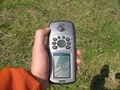
| + | Image:2014-06-25 51 9 GeorgDerReisende 2620.jpg | the proof | ||
| + | Image:2014-06-25 51 9 GeorgDerReisende 2622.jpg | [http://coord.info/GC48VRH] GC48VRH not reached | ||
| + | Image:2014-06-25 51 9 GeorgDerReisende 2628.jpg | view to the east | ||
| + | Image:2014-06-25 51 9 GeorgDerReisende 2630.jpg | view to the west | ||
| + | Image:2014-06-25 51 9 GeorgDerReisende 2632.jpg | the geohasher | ||
| + | Image:2014-06-25 51 9 GeorgDerReisende 2684.jpg | Hohengandern | ||
</gallery> | </gallery> | ||
| Line 44: | Line 47: | ||
<!-- Add any achievement ribbons you earned below, or remove this section --> | <!-- Add any achievement ribbons you earned below, or remove this section --> | ||
| + | {{Thumbs Up | latitude = 51 | longitude = 9 | date = 2014-06-25 | name = GeorgDerReisende }} | ||
| − | + | [[Category:Expeditions]] | |
| − | |||
| − | [[Category: | ||
| − | + | [[Category:Expeditions with photos]] | |
| − | |||
| − | |||
| − | |||
| − | |||
| − | |||
| − | |||
| − | |||
| − | |||
| − | |||
| − | |||
| − | |||
| − | |||
| − | |||
| − | |||
[[Category:Coordinates reached]] | [[Category:Coordinates reached]] | ||
| − | + | {{location|DE|TH|EIC}} | |
| − | |||
| − | |||
| − | |||
| − | |||
| − | |||
| − | |||
| − | |||
| − | |||
| − | |||
| − | |||
| − | |||
| − | |||
| − | |||
| − | |||
| − | |||
| − | |||
| − | |||
Latest revision as of 00:32, 15 August 2019
| Wed 25 Jun 2014 in 51,9: 51.3682357, 9.9276662 geohashing.info google osm bing/os kml crox |
Location
The hash lay on a meadow near Hohengandern.
Participants
Plans
Hitchhiking.
Expedition
I started my expedition at 10:30, started to hitchhike at 11:30 and arrived with four cars at Eichenberg at 12:45. I walked zigzag through the countryside, looking for some geocaches, and arrived near the hash at 14:33. I found the hash not on the street, but some meters on the meadow. The meadow had a fence, electric wired. But at one place I found in fence one wire a bit higher then elsewhere. The reason might be the geocache behind the meadow, on the other side of the meadow was a similar hole. I crawled beyond the wire and found the hash on the field. I didn't go to the nearby geocache, because I couldn't find a trail to it. Afterwards I looked for more geocaches. I started to travel home from Hohengandern at 17:50 and arrived at Kassel at 19:04 with two cars.
Tracklog
Photos
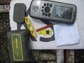
[1] GC41671
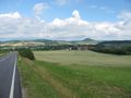
view to Hohengandern
view to the hash
the "hole" of the hash
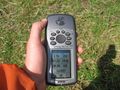
the proof
[2] GC48VRH not reached
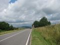
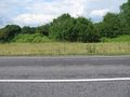
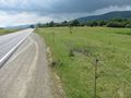
view to the east
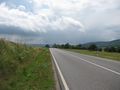
view to the west
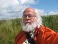
the geohasher
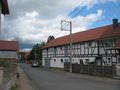
Hohengandern


Achievements
GeorgDerReisende earned the Thumbs Up Geohash Achievement
|