Difference between revisions of "2014-07-06 50 8"
From Geohashing
imported>Rincewind (Stupid hash grin) |
imported>FippeBot m (Location) |
||
| (6 intermediate revisions by 3 users not shown) | |||
| Line 1: | Line 1: | ||
| − | |||
| − | |||
| − | |||
| − | |||
| − | |||
| − | |||
| − | |||
| − | |||
| − | |||
{{meetup graticule | {{meetup graticule | ||
| − | | lat=50 | + | | lat=50 |
| − | | lon=8 | + | | lon=8 |
| − | | date=2014-07-06 | + | | date=2014-07-06 |
}} | }} | ||
| − | |||
| − | |||
== Location == | == Location == | ||
| − | + | ||
| + | On a field near Steinbach, Hessen. | ||
== Participants == | == Participants == | ||
| − | + | *[[User:Yakamoz|Yakamoz]] | |
| − | + | *[[User:Rincewind| Rincewind]] | |
| + | |||
== Plans == | == Plans == | ||
| − | + | Rincewind told Mampfred that the Sunday geohash lies close to Gießen and suggested to go geohashing together. Due to time and distance reasons it didn't work and just the two of us went hashing. | |
== Expedition == | == Expedition == | ||
| − | + | After our typical Sunday late lunch we drove to Steinbach. The geohash point was easy to reach. We had to walk about 150 m on a track trough a farm and a next to a cowhouse. We were lucky that the geohash field was unfenced. Then the usual stuff: geohash dancing (one with a GPS gear and another with a smartphone), some photos (of us and the neighbourhood), then went back and drove home... This was easy. :) | |
| − | |||
| − | |||
| − | |||
== Photos == | == Photos == | ||
| Line 44: | Line 32: | ||
Image:2014-07-06_50_8_Rincewind_-1.jpg | Stupid hash grin | Image:2014-07-06_50_8_Rincewind_-1.jpg | Stupid hash grin | ||
| + | |||
| + | Image:2014-07-06_50_8_Rincewind_1404653306967.jpg | An interested watcher | ||
| + | Image:2014-07-06_50_8_hashproof.jpg | GPS screenshot | ||
</gallery> | </gallery> | ||
== Achievements == | == Achievements == | ||
{{#vardefine:ribbonwidth|800px}} | {{#vardefine:ribbonwidth|800px}} | ||
| − | |||
| − | |||
| − | + | {{land geohash | |
| − | + | | latitude = 50 | |
| − | + | | longitude = 8 | |
| + | | date = 2014-07-06 | ||
| + | | name = Yakamoz and Rincewind | ||
| + | }} | ||
| − | |||
| − | |||
| − | |||
| − | |||
| − | |||
| − | |||
| − | |||
| − | |||
[[Category:Expeditions]] | [[Category:Expeditions]] | ||
| − | |||
[[Category:Expeditions with photos]] | [[Category:Expeditions with photos]] | ||
| − | |||
| − | |||
| − | |||
| − | |||
| − | |||
[[Category:Coordinates reached]] | [[Category:Coordinates reached]] | ||
| − | + | {{location|DE|HE|GI}} | |
| − | |||
| − | |||
| − | |||
| − | |||
| − | |||
| − | |||
| − | |||
| − | |||
| − | |||
| − | |||
| − | |||
| − | |||
| − | |||
| − | |||
| − | |||
| − | |||
| − | |||
Latest revision as of 00:38, 15 August 2019
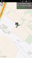
| Sun 6 Jul 2014 in 50,8: 50.5483119, 8.7884283 geohashing.info google osm bing/os kml crox |
Location
On a field near Steinbach, Hessen.
Participants
Plans
Rincewind told Mampfred that the Sunday geohash lies close to Gießen and suggested to go geohashing together. Due to time and distance reasons it didn't work and just the two of us went hashing.
Expedition
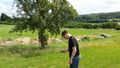
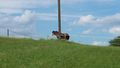
After our typical Sunday late lunch we drove to Steinbach. The geohash point was easy to reach. We had to walk about 150 m on a track trough a farm and a next to a cowhouse. We were lucky that the geohash field was unfenced. Then the usual stuff: geohash dancing (one with a GPS gear and another with a smartphone), some photos (of us and the neighbourhood), then went back and drove home... This was easy. :)
Photos
Coordinates reached
Hash dancing

Stupid hash grin
An interested watcher
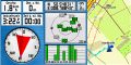
GPS screenshot


Achievements
Yakamoz and Rincewind earned the Land geohash achievement
|