Difference between revisions of "2014-07-15 43 -85"
From Geohashing
imported>Mcbaneg (→Expedition) |
imported>FippeBot m (Location) |
||
| (One intermediate revision by one other user not shown) | |||
| Line 37: | Line 37: | ||
Image:2014-07-15 43 -85 0.jpg | View south from hashpoint toward medical building. | Image:2014-07-15 43 -85 0.jpg | View south from hashpoint toward medical building. | ||
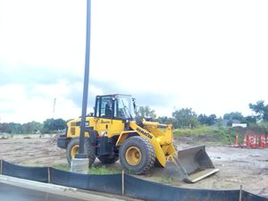
Image:2014-07-15 43 -85 2.jpg | Driveway and parking lot still under development... | Image:2014-07-15 43 -85 2.jpg | Driveway and parking lot still under development... | ||
| − | Image:2014-07-15 43 - | + | Image:2014-07-15 43 -85_13.jpg | Grin, sort of. |
Image:2014-07-15 43 -85_proof.png | Proof. | Image:2014-07-15 43 -85_proof.png | Proof. | ||
</gallery> | </gallery> | ||
| Line 60: | Line 60: | ||
[[Category:Expeditions with photos]] | [[Category:Expeditions with photos]] | ||
[[Category:Coordinates reached]] | [[Category:Coordinates reached]] | ||
| + | {{location|US|MI|KN}} | ||
Latest revision as of 00:44, 15 August 2019
| Tue 15 Jul 2014 in 43,-85: 43.0128084, -85.5887894 geohashing.info google osm bing/os kml crox |
Location
Driveway of a medical office building, Grand Rapids Charter Township, MI, USA
Participants
Expedition
Very easy after-work detour on my commute home. The hashpoint was on the driveway of a brand-new medical office building. Amusingly the driveway does show up on Google Maps but it's sufficiently new that the satmap shows a road marker superimposed on unbroken grassy field.
Achievements
George earned the Land geohash achievement
|


