Difference between revisions of "2014-07-20 44 -123"
imported>Frogman (Created page with "{{subst:Expedition |lat = 44 |lon = -123 |date = 2014-07-20 }}") |
imported>FippeBot m (Location) |
||
| (6 intermediate revisions by one other user not shown) | |||
| Line 18: | Line 18: | ||
__NOTOC__ | __NOTOC__ | ||
== Location == | == Location == | ||
| − | + | On the side of Mary's Peak in Siuslaw National Forest. | |
== Participants == | == Participants == | ||
| − | + | *[[User:Frogman|Frogman]] | |
| − | + | *Cameron | |
| + | *Eddie | ||
| + | *Alex | ||
== Plans == | == Plans == | ||
| Line 28: | Line 30: | ||
== Expedition == | == Expedition == | ||
| − | + | Unsure of the best way to go, we decided to park near the summit. After climbing to the summit for the amazing views, we began our descent into the forest. Switchbacks upon switchbacks followed, and eventually we left the trail to go bushwacking. We came across a cliff, but we found a safe way around, and ended up in a marshy area. The hashpoint was nearby. Also nearby was a road! Google Maps, with their limitless knowledge, had no idea that the road was there. It made for a better walk back then blazing another trail through the brush back up the hill. | |
== Tracklog == | == Tracklog == | ||
| Line 38: | Line 40: | ||
--> | --> | ||
<gallery perrow="5"> | <gallery perrow="5"> | ||
| + | File:2014-07-20 16.17.35.jpg | We're here! | ||
| + | File:2014-07-20 16.26.57.jpg | The view was magnificent. | ||
| + | File:2014-07-20 16.44.34.jpg | | ||
| + | File:2014-07-20 16.44.43.jpg | Radio equipment! | ||
| + | File:2014-07-20 16.45.16.jpg | | ||
| + | File:2014-07-20 17.08.46.jpg | Into the forest | ||
| + | File:2014-07-20 18.15.14.jpg | The marshy area. | ||
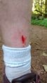
| + | File:2014-07-20 18.15.40.jpg | Shoes got a little wet! | ||
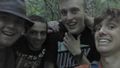
| + | File:2014-07-20 18.17.18.jpg | A bit crazed after a long hike. Still more walking to come! | ||
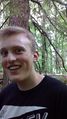
| + | File:2014-07-20 18.26.22.jpg | Grins! | ||
| + | File:2014-07-20 18.56.03.jpg | Raptor attack. | ||
| + | File:2014-07-20 19.56.56.jpg | Back out of the forest! The sun was beautiful. | ||
| + | File:2014-07-20 19.57.06.jpg | Walking back to the car. | ||
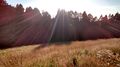
| + | File:2014-07-20 19.58.33.jpg | The parking lot, and a field. | ||
</gallery> | </gallery> | ||
| Line 43: | Line 59: | ||
{{#vardefine:ribbonwidth|800px}} | {{#vardefine:ribbonwidth|800px}} | ||
<!-- Add any achievement ribbons you earned below, or remove this section --> | <!-- Add any achievement ribbons you earned below, or remove this section --> | ||
| − | + | {{drag-along | |
| − | + | | latitude = 44 | |
| − | + | | longitude = -123 | |
| − | + | | date = 2014-07-20 | |
| − | [[ | + | | partner = Cameron, Eddie, Alex |
| − | + | | name = [[User:Frogman|Frogman]] | |
| − | + | | image = 2014-07-20 18.26.22.jpg | |
| − | + | }} | |
| − | |||
| − | |||
| − | |||
| − | |||
| − | |||
| − | |||
[[Category:Expeditions]] | [[Category:Expeditions]] | ||
| − | |||
[[Category:Expeditions with photos]] | [[Category:Expeditions with photos]] | ||
| − | |||
| − | |||
| − | |||
| − | |||
| − | |||
[[Category:Coordinates reached]] | [[Category:Coordinates reached]] | ||
| − | + | {{location|US|OR|BE}} | |
| − | |||
| − | |||
| − | |||
| − | |||
| − | |||
| − | |||
| − | |||
| − | |||
| − | |||
| − | |||
| − | |||
| − | |||
| − | |||
| − | |||
| − | |||
| − | |||
| − | |||
Latest revision as of 00:46, 15 August 2019
| Sun 20 Jul 2014 in 44,-123: 44.5050784, -123.5392008 geohashing.info google osm bing/os kml crox |
Location
On the side of Mary's Peak in Siuslaw National Forest.
Participants
- Frogman
- Cameron
- Eddie
- Alex
Plans
Expedition
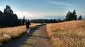
Unsure of the best way to go, we decided to park near the summit. After climbing to the summit for the amazing views, we began our descent into the forest. Switchbacks upon switchbacks followed, and eventually we left the trail to go bushwacking. We came across a cliff, but we found a safe way around, and ended up in a marshy area. The hashpoint was nearby. Also nearby was a road! Google Maps, with their limitless knowledge, had no idea that the road was there. It made for a better walk back then blazing another trail through the brush back up the hill.
Tracklog
Photos
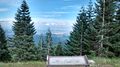
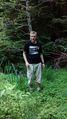
We're here!
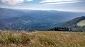
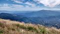
The view was magnificent.
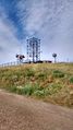
Radio equipment!
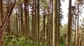
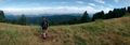
Into the forest
The marshy area.
Shoes got a little wet!
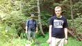
A bit crazed after a long hike. Still more walking to come!
Grins!
Raptor attack.
Back out of the forest! The sun was beautiful.
Walking back to the car.
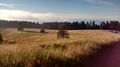
The parking lot, and a field.


Achievements
Frogman earned the Drag-along achievement
|