Difference between revisions of "2014-08-01 54 -2"
From Geohashing
imported>Angel ([live] 2.4 miles away, it's got to be worth walking out there to see if its accessible) |
imported>FippeBot m (Location) |
||
| (4 intermediate revisions by 2 users not shown) | |||
| Line 40: | Line 40: | ||
--> | --> | ||
<gallery perrow="5"> | <gallery perrow="5"> | ||
| + | |||
| + | Image:2014-08-01_54_-2_angel_1406897746959.jpg | I tjink it's in that field… [http://www.openstreetmap.org/?lat=54.07470000&lon=-2.75883000&zoom=16&layers=B000FTF @54.0747,-2.7588] | ||
| + | |||
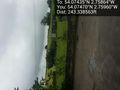
| + | Image:2014-08-01_54_-2_angel_1406898119719.jpg | why does it say 21ft, when the distance on the hashing app said 12 both before and sfter? My selfie arms can't be ''that'' long! [http://www.openstreetmap.org/?lat=54.07440000&lon=-2.75868000&zoom=16&layers=B000FTF @54.0744,-2.7587] | ||
| + | |||
| + | Image:2014-08-01_54_-2_angel_1406898457996.jpg | I made the hash, and so did a horse. Is there an acheivement for that? [http://www.openstreetmap.org/?lat=54.07470000&lon=-2.75960000&zoom=16&layers=B000FTF @54.0747,-2.7596] | ||
</gallery> | </gallery> | ||
| Line 47: | Line 53: | ||
| − | |||
| − | |||
| − | |||
| − | |||
| − | |||
| − | |||
| − | |||
| − | |||
| − | |||
| − | |||
| − | |||
[[Category:Expeditions]] | [[Category:Expeditions]] | ||
| − | |||
[[Category:Expeditions with photos]] | [[Category:Expeditions with photos]] | ||
| − | |||
| − | |||
| − | |||
| − | |||
| − | |||
[[Category:Coordinates reached]] | [[Category:Coordinates reached]] | ||
| − | + | {{location|GB|ENG|LAN}} | |
| − | |||
| − | |||
| − | |||
| − | |||
| − | |||
| − | |||
| − | |||
| − | |||
| − | |||
| − | |||
| − | |||
| − | |||
| − | |||
| − | |||
| − | |||
| − | |||
| − | |||
Latest revision as of 00:52, 15 August 2019
| Fri 1 Aug 2014 in 54,-2: 54.0743483, -2.7586376 geohashing.info google osm bing/os kml crox |
Location
Participants
Plans
Expedition
- 2.4 miles away, it's got to be worth walking out there to see if its accessible -- Angel (talk) @54.0482,-2.7984 07:10, 1 August 2014 (EDT)
Tracklog
Photos
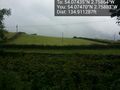
I tjink it's in that field… @54.0747,-2.7588

why does it say 21ft, when the distance on the hashing app said 12 both before and sfter? My selfie arms can't be that long! @54.0744,-2.7587
I made the hash, and so did a horse. Is there an acheivement for that? @54.0747,-2.7596


