Difference between revisions of "2014-08-03 48 13"
imported>Mampfred (An expedition message sent via Geohash Droid for Android.) |
imported>FippeBot m (Location) |
||
| (3 intermediate revisions by one other user not shown) | |||
| Line 1: | Line 1: | ||
| − | |||
| − | |||
| − | |||
| − | |||
| − | |||
| − | |||
| − | |||
| − | |||
| − | |||
| − | |||
{{meetup graticule | {{meetup graticule | ||
| lat=48 | | lat=48 | ||
| Line 18: | Line 8: | ||
__NOTOC__ | __NOTOC__ | ||
== Location == | == Location == | ||
| − | + | On a meadow in Frauenau in Bavaria. | |
== Participants == | == Participants == | ||
| − | + | * [[User:Mampfred|Mampfred]] | |
| − | + | * [[User:LadyBB|LadyBB]] | |
| + | * [[User:EmmJay|EmmJay]] | ||
== Plans == | == Plans == | ||
| − | + | Mampfred, LadyBB and EmmJay are on holiday in the "Bayrische Wald" (Bavarian Woods?). The hash hasn't been as convenient as hoped in the last week or so so this one will have to do for now. Will try reaching it after a day at Bayerisch Eisenstein. | |
== Expedition == | == Expedition == | ||
| − | + | Easy as pie. We were in Bayerisch Eisenstein already which isn't too far away from Frauenau. Drove a good 10 minutes and the hash to be in a meadow although Google Maps looked like a field and made us worry unnecessary. In fact, the hash was right behind a gap between two buildings allowing us to pretty much walk straight to it from the street. We snapped some photos and went back to our flat to have a drink with some friends. | |
== Tracklog == | == Tracklog == | ||
| − | + | See [http://www.everytrail.com/view_trip.php?trip_id=2906251 here]. | |
== Photos == | == Photos == | ||
| − | |||
| − | |||
| − | |||
<gallery perrow="5"> | <gallery perrow="5"> | ||
| + | Image:2014-08-03_48_13_looking_toward_the_hash.jpg | Looking in the direction of the hash. | ||
| + | Image:2014-08-03_48_13_on_the_way.jpg | EmmJay and LadyBB on the way. | ||
| + | Image:2014-08-03_48_13_coordinates_reached.jpg | Coordinates reached | ||
| + | Image:2014-08-03_48_13_at_the_hash.jpg | At the hash. | ||
| + | Image:2014-08-03_48_13_group_shot_against_sun.jpg | Group shot against the sun ... bugger ... | ||
| + | Image:2014-08-03_48_13_group_shot_with_sun.jpg | Group shot :) | ||
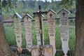
| + | Image:2014-08-03_48_13_family_grave_..._with_a_chuckle.jpg | ||
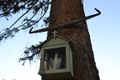
| + | Image:2014-08-03_48_13_atop_the_grave.jpg | ||
</gallery> | </gallery> | ||
== Achievements == | == Achievements == | ||
{{#vardefine:ribbonwidth|800px}} | {{#vardefine:ribbonwidth|800px}} | ||
| − | + | - | |
| − | |||
| − | |||
| − | |||
| − | |||
| − | |||
| − | |||
| − | |||
| − | |||
| − | |||
| − | |||
| − | |||
| − | |||
| − | |||
[[Category:Expeditions]] | [[Category:Expeditions]] | ||
| − | |||
[[Category:Expeditions with photos]] | [[Category:Expeditions with photos]] | ||
| − | |||
| − | |||
| − | |||
| − | |||
| − | |||
[[Category:Coordinates reached]] | [[Category:Coordinates reached]] | ||
| − | + | {{location|DE|BY|REG}} | |
| − | |||
| − | |||
| − | |||
| − | |||
| − | |||
| − | |||
| − | |||
| − | |||
| − | |||
| − | |||
| − | |||
| − | |||
| − | |||
| − | |||
| − | |||
| − | |||
| − | |||
Latest revision as of 00:29, 7 August 2019
| Sun 3 Aug 2014 in 48,13: 48.9887592, 13.3096274 geohashing.info google osm bing/os kml crox |
Location
On a meadow in Frauenau in Bavaria.
Participants
Plans
Mampfred, LadyBB and EmmJay are on holiday in the "Bayrische Wald" (Bavarian Woods?). The hash hasn't been as convenient as hoped in the last week or so so this one will have to do for now. Will try reaching it after a day at Bayerisch Eisenstein.
Expedition
Easy as pie. We were in Bayerisch Eisenstein already which isn't too far away from Frauenau. Drove a good 10 minutes and the hash to be in a meadow although Google Maps looked like a field and made us worry unnecessary. In fact, the hash was right behind a gap between two buildings allowing us to pretty much walk straight to it from the street. We snapped some photos and went back to our flat to have a drink with some friends.
Tracklog
See here.
Photos

Looking in the direction of the hash.
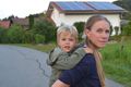
EmmJay and LadyBB on the way.
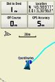
Coordinates reached
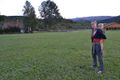
At the hash.

Group shot against the sun ... bugger ...
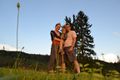
Group shot :)


Achievements
-