Difference between revisions of "2014-09-15 48 16"
From Geohashing
imported>B2c |
imported>FippeBot m (Location) |
||
| (5 intermediate revisions by 3 users not shown) | |||
| Line 9: | Line 9: | ||
== Location == | == Location == | ||
| − | + | The hash was located at a field just a few meters off the main road close to Neusiedl an der Zaya, Lower Austria. | |
| − | |||
== Participants == | == Participants == | ||
| + | * [[User:Patrizius|Patrizius]] | ||
| + | * [[User:B2c|B2c]] | ||
== Plans == | == Plans == | ||
| + | Looking at the map we realized that the hash was very close to a main road, just a few meters into a field. At that point there is no need for big plans. Just get there and go grab it! | ||
| + | == Expedition == | ||
| + | The weather was nice and the traffic wasn't too bad either, so it was a very pleasant trip to the location. We parked the hashmobile and just took a stroll across the field towards hashpoint. Can't get any easier than this.. | ||
| − | |||
*Yay -- [[User:Patrizius|Patrizius]] ([[User talk:Patrizius|talk]]) [http://www.openstreetmap.org/?lat=48.60887150&lon=16.77754580&zoom=16&layers=B000FTF @48.6089,16.7775] 18:15, 15 September 2014 (CEST) | *Yay -- [[User:Patrizius|Patrizius]] ([[User talk:Patrizius|talk]]) [http://www.openstreetmap.org/?lat=48.60887150&lon=16.77754580&zoom=16&layers=B000FTF @48.6089,16.7775] 18:15, 15 September 2014 (CEST) | ||
| − | |||
== Tracklog == | == Tracklog == | ||
| Line 26: | Line 28: | ||
== Photos == | == Photos == | ||
<gallery caption="Photo Gallery" widths="320px" heights="213px" perrow="3"> | <gallery caption="Photo Gallery" widths="320px" heights="213px" perrow="3"> | ||
| + | Image:IMG_20140915_181136.jpg | | ||
| + | Image:IMG_20140915_181230.jpg | | ||
| + | Image:IMG_20140915_181327.jpg | | ||
| + | Image:IMG_20140915_181410.jpg | | ||
| + | Image:IMG_20140915_181548.jpg | | ||
| + | Image:Screenshot_2014-09-15-18-14-10.png | | ||
| + | Image:Screenshot_2014-09-15-18-15-02.png | | ||
Image:Gpsvisualizer-2014-09-15-wien-zoom.png | Tracklog - zoomed in view of the hash location. | Image:Gpsvisualizer-2014-09-15-wien-zoom.png | Tracklog - zoomed in view of the hash location. | ||
| − | |||
</gallery> | </gallery> | ||
| − | + | ||
| + | == Achievements == | ||
| + | {{consecutive geohash 2 | ||
| + | | count = 13 | ||
| + | | latitude = 47 | ||
| + | | longitude = 14 | ||
| + | | date = 2014-09-03 | ||
| + | | name = B2c | ||
| + | }} | ||
| + | {{consecutive geohash 2 | ||
| + | | count = 13 | ||
| + | | latitude = 47 | ||
| + | | longitude = 14 | ||
| + | | date = 2014-09-03 | ||
| + | | name = Patrizius | ||
| + | }} | ||
| + | |||
| + | |||
[[Category:Expeditions]] | [[Category:Expeditions]] | ||
[[Category:Expeditions with photos]] | [[Category:Expeditions with photos]] | ||
[[Category:Coordinates reached]] | [[Category:Coordinates reached]] | ||
| + | {{location|AT|NÖ|GF}} | ||
Latest revision as of 01:26, 15 August 2019
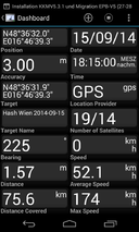
| Mon 15 Sep 2014 in 48,16: 48.6088691, 16.7775704 geohashing.info google osm bing/os kml crox |
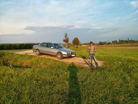
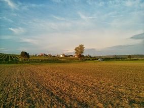
Location
The hash was located at a field just a few meters off the main road close to Neusiedl an der Zaya, Lower Austria.
Participants
Plans
Looking at the map we realized that the hash was very close to a main road, just a few meters into a field. At that point there is no need for big plans. Just get there and go grab it!
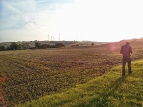
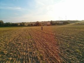
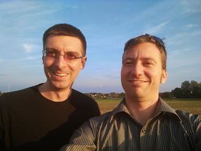
Expedition
The weather was nice and the traffic wasn't too bad either, so it was a very pleasant trip to the location. We parked the hashmobile and just took a stroll across the field towards hashpoint. Can't get any easier than this..
- Yay -- Patrizius (talk) @48.6089,16.7775 18:15, 15 September 2014 (CEST)
Tracklog

Photos
- Photo Gallery
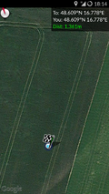
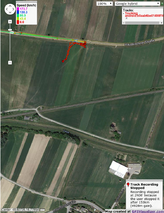
Tracklog - zoomed in view of the hash location.


Achievements
B2c earned the Consecutive geohash achievement
|
Patrizius earned the Consecutive geohash achievement
|