Difference between revisions of "2014-09-20 48 9"
From Geohashing
imported>GeorgDerReisende (new expedition) |
imported>FippeBot m (Location) |
||
| (5 intermediate revisions by one other user not shown) | |||
| Line 1: | Line 1: | ||
| − | |||
| − | |||
| − | |||
| − | |||
| − | |||
| − | |||
| − | |||
| − | |||
| − | |||
| − | |||
{{meetup graticule | {{meetup graticule | ||
| lat=48 | | lat=48 | ||
| Line 18: | Line 8: | ||
__NOTOC__ | __NOTOC__ | ||
== Location == | == Location == | ||
| − | + | ||
| + | The hash is located on the Dornhaldenfriedhof at Stuttgart. | ||
== Participants == | == Participants == | ||
| − | + | ||
| − | + | [[User:GeorgDerReisende|GeorgDerReisende]] | |
== Plans == | == Plans == | ||
| − | + | ||
| + | I am just starting now (7:50). I am hitchhiking. I think I will need eight hours. But don't wait for me. | ||
== Expedition == | == Expedition == | ||
| − | |||
| − | + | I started to hitchhike at 8:30 and got a truck after 15 minutes. With four more cars I arrived at Stuttgart-Vaihingen at 16:30. At the cemetery I arrived at 17:30. | |
| − | |||
== Photos == | == Photos == | ||
| − | |||
| − | |||
| − | |||
<gallery perrow="5"> | <gallery perrow="5"> | ||
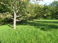
| + | Image:2014-09-20 48 9 GeorgDerReisende 6429.jpg | on this side of the dyke not near enough | ||
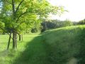
| + | Image:2014-09-20 48 9 GeorgDerReisende 6432.jpg | the hash | ||
| + | Image:2014-09-20 48 9 GeorgDerReisende 6434.jpg | proof | ||
| + | Image:2014-09-20 48 9 GeorgDerReisende 6437.jpg | look to north | ||
| + | Image:2014-09-20 48 9 GeorgDerReisende 6438.jpg | look to east | ||
| + | Image:2014-09-20 48 9 GeorgDerReisende 6439.jpg | look to south | ||
| + | Image:2014-09-20 48 9 GeorgDerReisende 6440.jpg | look to the geohasher | ||
| + | Image:2014-09-20 48 9 GeorgDerReisende 6445.jpg | the site from above: the hash lay at the small light green tree in the middle | ||
| + | Image:2014-09-20 48 9 GeorgDerReisende 6451.jpg | view to Stuttgart from Degerloch | ||
</gallery> | </gallery> | ||
| Line 44: | Line 40: | ||
<!-- Add any achievement ribbons you earned below, or remove this section --> | <!-- Add any achievement ribbons you earned below, or remove this section --> | ||
| + | {{Thumbs Up | latitude = 48 | longitude = 9 | date = 2014-09-20 | name = GeorgDerReisende }} | ||
| − | + | [[Category:Expeditions]] | |
| − | |||
| − | [[Category: | ||
| − | + | [[Category:Expeditions with photos]] | |
| − | |||
| − | |||
| − | |||
| − | [[Category: | ||
| − | |||
| − | |||
| − | |||
| − | |||
| − | |||
| − | |||
| − | |||
| − | |||
| − | |||
| − | |||
[[Category:Coordinates reached]] | [[Category:Coordinates reached]] | ||
| − | + | {{location|DE|BW|S}} | |
| − | |||
| − | |||
| − | |||
| − | |||
| − | |||
| − | |||
| − | |||
| − | |||
| − | |||
| − | |||
| − | |||
| − | |||
| − | |||
| − | |||
| − | |||
| − | |||
| − | |||
Latest revision as of 01:31, 15 August 2019
| Sat 20 Sep 2014 in 48,9: 48.7528903, 9.1550111 geohashing.info google osm bing/os kml crox |
Location
The hash is located on the Dornhaldenfriedhof at Stuttgart.
Participants
Plans
I am just starting now (7:50). I am hitchhiking. I think I will need eight hours. But don't wait for me.
Expedition
I started to hitchhike at 8:30 and got a truck after 15 minutes. With four more cars I arrived at Stuttgart-Vaihingen at 16:30. At the cemetery I arrived at 17:30.
Photos
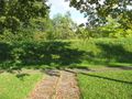
on this side of the dyke not near enough
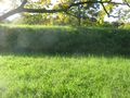
the hash
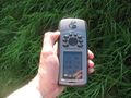
proof
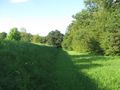
look to north
look to east
look to south

look to the geohasher
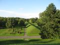
the site from above: the hash lay at the small light green tree in the middle
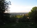
view to Stuttgart from Degerloch


Achievements
GeorgDerReisende earned the Thumbs Up Geohash Achievement
|