Difference between revisions of "2014-09-26 52 9"
From Geohashing
imported>GeorgDerReisende (expedition report for Bergen) |
imported>FippeBot m (Location) |
||
| (3 intermediate revisions by one other user not shown) | |||
| Line 1: | Line 1: | ||
| − | + | {{meetup graticule | |
| lat=52 | | lat=52 | ||
| lon=9 | | lon=9 | ||
| date=2014-09-26 | | date=2014-09-26 | ||
| − | }} | + | }} |
<!-- edit as necessary --> | <!-- edit as necessary --> | ||
| Line 9: | Line 9: | ||
== Location == | == Location == | ||
| − | The hash | + | The hash lay near the national road B3 at the southern end of Bergen. |
== Participants == | == Participants == | ||
| Line 47: | Line 47: | ||
[[Category:Coordinates reached]] | [[Category:Coordinates reached]] | ||
| + | {{location|DE|NI|CE}} | ||
Latest revision as of 01:35, 15 August 2019
| Fri 26 Sep 2014 in 52,9: 52.7315253, 9.9747469 geohashing.info google osm bing/os kml crox |
Location
The hash lay near the national road B3 at the southern end of Bergen.
Participants
Plans
I wanted to hitchhike to that place. Walking seemed not possible.
Expedition
From Kassel I hitchhiked to the junction Soltau Süd of the motorway A7 with the first car. From there I hitchhiked to Bergen-Hassel with the second car. The hash seemed to be near the cycling path, but it was deep in the forest. For the way home I needed five cars.
Photos
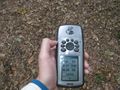
proof

view to the road
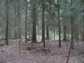
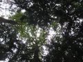
view into the forest (all three directions looked the same)

the geohasher
the reason for the bad signal

behind the road: kaboom (no thunderstorm)

view along the road, to the south

view along the road, to the north

the name of the place is Hassel, the name of the quarter is Achterberg


Achievements
GeorgDerReisende earned the Thumbs Up Geohash Achievement
|