Difference between revisions of "2014-11-01 47 8"
imported>Chris 47 8 (page created) |
imported>FippeBot m (Location) |
||
| (4 intermediate revisions by one other user not shown) | |||
| Line 1: | Line 1: | ||
| − | |||
| − | |||
| − | |||
| − | |||
| − | |||
| − | |||
| − | |||
| − | |||
| − | |||
{{meetup graticule | {{meetup graticule | ||
| lat=47 | | lat=47 | ||
| Line 15: | Line 6: | ||
}} | }} | ||
| − | + | ||
__NOTOC__ | __NOTOC__ | ||
== Location == | == Location == | ||
| − | + | In a field in Dietlikon | |
== Participants == | == Participants == | ||
| − | + | *[[User:Chris 47 8|Chris 47 8]] | |
| − | |||
== Plans == | == Plans == | ||
| − | + | Saturday meetup in Dietlikon! I'll be there at 2pm. | |
== Expedition == | == Expedition == | ||
| − | + | ||
| + | I haven't been hashing for quite some time, so i was glad to see that the coordinates for this saturday fell not too far from town. I set the time for 2pm, but nobody replied, so i went there alone. [[User:Calamus|Calamus]], where are you? | ||
| + | The hashpoint was in a field in Dietlikon, not too far from the last hash i've visited in [[2014-02-27 47 8|Wallisellen]]. I took a train to the nearest station and walked there. On the way was an enclosure for some goats. It was a nice sunny and warm afternoon. Close to the hash lies a property of the 'Rabbit and poultry breeding association of Wallisellen'. Lots of cages there with all sorts of birds. I didn't see any rabbits, though. | ||
| + | |||
| + | I found the hash in the field quite easily. The old app to show coordinates didn't work anymore on the new iOS system, so i had to download a new one, which works even smoother and faster than the old one. During my stay on the spot, several airplanes flew over the place on a very low altitude. The hash lies directly under a departure corridor of the airport. When taking off south, planes have to make a sharp left curve, for whatever reason. So lots of planes flew directly over me in a very steep lateral position, which looked fairly impressive. And it was loud like hell. | ||
| + | |||
| + | I took a few pictures and went home. It was my 20th expedition, and they were all successful so far! | ||
== Tracklog == | == Tracklog == | ||
| − | + | nope | |
== Photos == | == Photos == | ||
| − | |||
| − | |||
| − | |||
<gallery perrow="5"> | <gallery perrow="5"> | ||
| + | Image:2014110147801.JPG|Dietlikon station | ||
| + | Image:2014110147803.JPG|Goats | ||
| + | Image:2014110147804.JPG|Welcome to Wallisellen | ||
| + | Image:2014110147805.JPG|It says 'Rabbit and poultry breeding association of Wallisellen' | ||
| + | Image:2014110147806.JPG|No rabbit | ||
| + | Image:2014110147807.PNG|Coordinates reached | ||
| + | Image:2014110147808.JPG|The place | ||
| + | Image:2014110147809.JPG|View south | ||
| + | Image:2014110147810.JPG|View north | ||
| + | Image:2014110147802.JPG|View up | ||
</gallery> | </gallery> | ||
| Line 43: | Line 46: | ||
{{#vardefine:ribbonwidth|800px}} | {{#vardefine:ribbonwidth|800px}} | ||
<!-- Add any achievement ribbons you earned below, or remove this section --> | <!-- Add any achievement ribbons you earned below, or remove this section --> | ||
| + | none of interest | ||
| − | |||
| − | |||
| − | |||
| − | |||
| − | |||
| − | |||
| − | |||
| − | |||
| − | |||
| − | |||
| − | |||
| − | |||
[[Category:Expeditions]] | [[Category:Expeditions]] | ||
| − | + | [[Category:Expeditions with photos]] | |
| − | [[Category:Expeditions with photos]] | ||
| − | |||
| − | |||
| − | |||
| − | |||
| − | |||
[[Category:Coordinates reached]] | [[Category:Coordinates reached]] | ||
| − | + | {{location|CH|ZH}} | |
| − | |||
| − | |||
| − | |||
| − | |||
| − | |||
| − | |||
| − | |||
| − | |||
| − | |||
| − | |||
| − | |||
| − | |||
| − | |||
| − | |||
| − | |||
| − | |||
| − | |||
Latest revision as of 01:51, 15 August 2019
| Sat 1 Nov 2014 in 47,8: 47.4224011, 8.6065222 geohashing.info google osm bing/os kml crox |
Location
In a field in Dietlikon
Participants
Plans
Saturday meetup in Dietlikon! I'll be there at 2pm.
Expedition
I haven't been hashing for quite some time, so i was glad to see that the coordinates for this saturday fell not too far from town. I set the time for 2pm, but nobody replied, so i went there alone. Calamus, where are you? The hashpoint was in a field in Dietlikon, not too far from the last hash i've visited in Wallisellen. I took a train to the nearest station and walked there. On the way was an enclosure for some goats. It was a nice sunny and warm afternoon. Close to the hash lies a property of the 'Rabbit and poultry breeding association of Wallisellen'. Lots of cages there with all sorts of birds. I didn't see any rabbits, though.
I found the hash in the field quite easily. The old app to show coordinates didn't work anymore on the new iOS system, so i had to download a new one, which works even smoother and faster than the old one. During my stay on the spot, several airplanes flew over the place on a very low altitude. The hash lies directly under a departure corridor of the airport. When taking off south, planes have to make a sharp left curve, for whatever reason. So lots of planes flew directly over me in a very steep lateral position, which looked fairly impressive. And it was loud like hell.
I took a few pictures and went home. It was my 20th expedition, and they were all successful so far!
Tracklog
nope
Photos
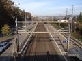
Dietlikon station
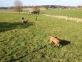
Goats
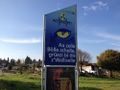
Welcome to Wallisellen
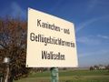
It says 'Rabbit and poultry breeding association of Wallisellen'

No rabbit
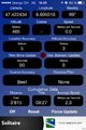
Coordinates reached
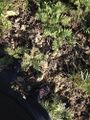
The place
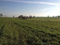
View south
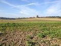
View north
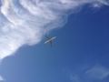
View up


Achievements
none of interest