Difference between revisions of "2014-11-03 59 18"
imported>Odberger (Created page with " <!-- If you did not specify these parameters in the template, please substitute appropriate values for IMAGE, LAT, LON, and DATE (YYYY-MM-DD format) Image:{{{image|IMAGE}...") |
imported>FippeBot m (Location) |
||
| (5 intermediate revisions by 2 users not shown) | |||
| Line 18: | Line 18: | ||
__NOTOC__ | __NOTOC__ | ||
== Location == | == Location == | ||
| − | Gärdet, which is a park like area | + | Gärdet, which is a park like area north east of center of Stockholm, Sweden |
== Participants == | == Participants == | ||
| Line 24: | Line 24: | ||
== Plans == | == Plans == | ||
| − | This will be my second Geohash ever. I have started to check the daily geohash to see if it's nearby. This one is only | + | This will be my second Geohash ever. I have started to check the daily geohash to see if it's nearby. This one is only 10km from my work and I'll visit the place during lunch |
== Expedition == | == Expedition == | ||
| − | + | During lunch I took the car and parked near the coordinates of today. After a short walk for about 150m I found myself standing on Ground Zero. I put up [http://geo.crox.net/poster/2014-11-03_59_18 info about geohashing] on the nearest tree and I took a selfie with that tree in the background. Then I continued to pick upp my "[http://http://coord.info/GC3C1KB geocache] for the day" which was about 140m away from GZ. I know that I was a bit early as the standard meeting time is 16:00 (4 pm), but today I'm busy at work then. I hope that somebody else will be there at that time. | |
| − | |||
== Tracklog == | == Tracklog == | ||
| Line 38: | Line 37: | ||
--> | --> | ||
<gallery perrow="5"> | <gallery perrow="5"> | ||
| + | |||
| + | Image:2014-11-03_59_18_Odberger_1415013776210.jpg | Me visiting today's Geohash. [http://www.openstreetmap.org/?lat=59.32967932&lon=18.14495579&zoom=16&layers=B000FTF @59.3297,18.1450] | ||
</gallery> | </gallery> | ||
| Line 45: | Line 46: | ||
| − | + | [[Category:Expeditions]] | |
| − | |||
| − | [[Category: | ||
| − | + | [[Category:Expeditions with photos]] | |
| − | |||
| − | |||
| − | |||
| − | [[Category: | ||
| − | |||
| − | |||
| − | |||
| − | |||
| − | |||
| − | |||
| − | |||
| − | |||
| − | |||
| − | |||
[[Category:Coordinates reached]] | [[Category:Coordinates reached]] | ||
| − | + | {{location|SE|AB}} | |
| − | |||
| − | |||
| − | |||
| − | |||
| − | |||
| − | |||
| − | |||
| − | |||
| − | |||
| − | |||
| − | |||
| − | |||
| − | |||
| − | |||
| − | |||
Latest revision as of 01:53, 15 August 2019
| Mon 3 Nov 2014 in 59,18: 59.3296737, 18.1449406 geohashing.info google osm bing/os kml crox |
Location
Gärdet, which is a park like area north east of center of Stockholm, Sweden
Participants
Plans
This will be my second Geohash ever. I have started to check the daily geohash to see if it's nearby. This one is only 10km from my work and I'll visit the place during lunch
Expedition
During lunch I took the car and parked near the coordinates of today. After a short walk for about 150m I found myself standing on Ground Zero. I put up info about geohashing on the nearest tree and I took a selfie with that tree in the background. Then I continued to pick upp my "geocache for the day" which was about 140m away from GZ. I know that I was a bit early as the standard meeting time is 16:00 (4 pm), but today I'm busy at work then. I hope that somebody else will be there at that time.
Tracklog
Photos
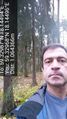
Me visiting today's Geohash. @59.3297,18.1450
