Difference between revisions of "2014-11-16 49 8"
imported>DLichti (→Plans: ETA 16:15) |
imported>FippeBot m (Location) |
||
| (5 intermediate revisions by one other user not shown) | |||
| Line 1: | Line 1: | ||
| + | [[Image:{{{image|2014-11-16_49_8_DLichti_power_mast.jpg}}}|thumb|left]] | ||
| − | |||
| − | |||
| − | |||
| − | |||
| − | |||
| − | |||
| − | |||
| − | |||
| − | |||
{{meetup graticule | {{meetup graticule | ||
| lat=49 | | lat=49 | ||
| Line 21: | Line 13: | ||
== Participants == | == Participants == | ||
| + | *[[User:DLichti|DLichti]] | ||
| + | *a friend | ||
<!-- who attended: If you link to your wiki user name in this section, your expedition will be picked up by the various statistics generated for geohashing. You may use three tildes ~ as a shortcut to automatically insert the user signature of the account you are editing with. | <!-- who attended: If you link to your wiki user name in this section, your expedition will be picked up by the various statistics generated for geohashing. You may use three tildes ~ as a shortcut to automatically insert the user signature of the account you are editing with. | ||
--> | --> | ||
| Line 29: | Line 23: | ||
== Expedition == | == Expedition == | ||
| − | + | First, I took the train to Karlsruhe. The alternatives to get to Ubstadt-Weiher were one train with 1 minute transfer time and another one with 61 minutes. I decided to take the latter and go to my friend's place during that time. On the way back to the main station, the tram was late. So, instead of 10 minutes, we only had 3 to get to the right platform. But we made it. | |
| + | |||
| + | After a 20 minute ride, we arrived at the train stop in Ubstadt-Weiher. From there, my phone suggested a 2.5 km promenade to the hash point. But we saved some time by just crossing a road instead of walking all the way to the next bridge over it and later by walking across the fields. So it probably rather turned out to be something like 2 km. It had rained earlier that day, the sky was still very cloudy and the grass very wet. We arrived at the hash point at around 16:15 as anticipated. | ||
| + | |||
| + | The point was located around 10 m into a field, right under the power line from Philippsburg to Stuttgart and close to the railway line Karlsruhe - Heidelberg and the high speed line Mannheim - Stuttgart. The field was harvested and plowed, so we ventured onto it to find the exact spot. My friend brought some snacks, so we had some bites while listening to the noise of wet high voltage insulators. We left at around 16:30. | ||
| − | + | On our way back, we picked up some algae and water plants for my friend's fish bowl. When we came by one of those road signs, that measure and display the cars' speed, we found out that you can trick it by just waving your hands in front of it. We tried how high we could score. Since my arms are longer, I won with 38 km/h. We took the train back to Karlsruhe where we even arrived without delay. While my friend stayed in Karlsruhe, I was able to catch my next train home. | |
| − | |||
| − | == Photos == | + | == Photos == |
| − | |||
| − | |||
| − | |||
<gallery perrow="5"> | <gallery perrow="5"> | ||
| + | Image:2014-11-16 49 8 DLichti sunset.jpg | A beautiful sunset behind the clouds (and power lines). | ||
| + | Image:2014-11-16 49 8 DLichti stream.jpg | Small stream on our way to the hash point. | ||
| + | Image:2014-11-16 49 8 DLichti power mast.jpg | An interesting power line bifurcation. | ||
| + | Image:2014-11-16_49_8_DLichti_hashpoint.jpg | The hash point is located on this field. | ||
| + | Image:2014-11-16 49 8 DLichti proof.png | We found it. | ||
</gallery> | </gallery> | ||
| Line 46: | Line 45: | ||
| − | |||
| − | |||
| − | |||
| − | |||
[[Category:Expeditions]] | [[Category:Expeditions]] | ||
| − | + | [[Category:Coordinates reached]] | |
[[Category:Expeditions with photos]] | [[Category:Expeditions with photos]] | ||
| − | + | {{location|DE|BW|KA}} | |
| − | |||
| − | |||
| − | |||
| − | |||
| − | |||
| − | |||
| − | |||
| − | |||
| − | |||
| − | |||
| − | |||
| − | |||
| − | |||
| − | |||
| − | |||
| − | |||
| − | |||
| − | |||
| − | |||
| − | |||
| − | |||
| − | |||
| − | |||
Latest revision as of 01:59, 15 August 2019

| Sun 16 Nov 2014 in 49,8: 49.1601714, 8.6072346 geohashing.info google osm bing/os kml crox |
Location
On a field between Ubstadt-Weiher and Forst.
Participants
- DLichti
- a friend
Plans
DLichti and a friend are planning to take the train to Ubstadt-Weiher and walk to the HP. We hope that it won't be raining too bad. ETA around 16:15.
Expedition
First, I took the train to Karlsruhe. The alternatives to get to Ubstadt-Weiher were one train with 1 minute transfer time and another one with 61 minutes. I decided to take the latter and go to my friend's place during that time. On the way back to the main station, the tram was late. So, instead of 10 minutes, we only had 3 to get to the right platform. But we made it.
After a 20 minute ride, we arrived at the train stop in Ubstadt-Weiher. From there, my phone suggested a 2.5 km promenade to the hash point. But we saved some time by just crossing a road instead of walking all the way to the next bridge over it and later by walking across the fields. So it probably rather turned out to be something like 2 km. It had rained earlier that day, the sky was still very cloudy and the grass very wet. We arrived at the hash point at around 16:15 as anticipated.
The point was located around 10 m into a field, right under the power line from Philippsburg to Stuttgart and close to the railway line Karlsruhe - Heidelberg and the high speed line Mannheim - Stuttgart. The field was harvested and plowed, so we ventured onto it to find the exact spot. My friend brought some snacks, so we had some bites while listening to the noise of wet high voltage insulators. We left at around 16:30.
On our way back, we picked up some algae and water plants for my friend's fish bowl. When we came by one of those road signs, that measure and display the cars' speed, we found out that you can trick it by just waving your hands in front of it. We tried how high we could score. Since my arms are longer, I won with 38 km/h. We took the train back to Karlsruhe where we even arrived without delay. While my friend stayed in Karlsruhe, I was able to catch my next train home.
Photos
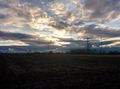
A beautiful sunset behind the clouds (and power lines).
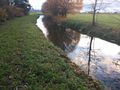
Small stream on our way to the hash point.

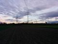
An interesting power line bifurcation.
The hash point is located on this field.

We found it.


