Difference between revisions of "2014-11-19 60 22"
imported>Suurnesu ([live picture] [http://www.openstreetmap.org/?lat=60.42270083&lon=22.51851490&zoom=16&layers=B000FTF @60.4227,22.5185]) |
imported>FippeBot m (Location) |
||
| (One intermediate revision by one other user not shown) | |||
| Line 1: | Line 1: | ||
| − | |||
| − | |||
| − | |||
| − | |||
| − | |||
| − | |||
| − | |||
| − | |||
{{meetup graticule | {{meetup graticule | ||
| lat=60 | | lat=60 | ||
| Line 18: | Line 10: | ||
__NOTOC__ | __NOTOC__ | ||
== Location == | == Location == | ||
| − | + | In Ex-Piikkiö, nowdays city of Kaarina. | |
== Participants == | == Participants == | ||
| − | + | [[User:Suurnesu|Suurnesu]] | |
| − | |||
| − | |||
| − | |||
| − | |||
== Expedition == | == Expedition == | ||
| − | + | I had noticed that today's hashpoint landed to a very easily accessible location next to a busy road leading from Turku to Helsinki. After 21 o'clock I was lying on a sofa and decided that a small expedition might cheer me up. | |
| + | So I jumped to my car and drove some 10 kilometers to Piikkiö. I left my car next to R-kiosk and walked approximately hudred meters to the hashpoint. As I had previously studied, the point was only one meter from a cycleway on a grass. It was dark but there were streetlights at the location. Only two cars passed me while I was trying to get as close to zero as possible. It was very easy this time because there was plenty of room to move and there were no trees or buildings which might have interfered GPS reception. | ||
| + | Eventually I was happy with the location, shot some pictures and drove back home. | ||
| + | Not a very thrilling geohash this time but doesn't matter. | ||
| − | * | + | *[[User:Suurnesu|suurnesu]] ([[User talk:Suurnesu|talk]]) [http://www.openstreetmap.org/?lat=60.42268752&lon=22.51858815&zoom=16&layers=B000FTF @60.4227,22.5186] 14:49, 19 November 2014 (EST) |
| − | |||
| − | |||
== Photos == | == Photos == | ||
| − | |||
| − | |||
| − | |||
<gallery perrow="5"> | <gallery perrow="5"> | ||
| − | Image:2014-11-19_60_22_Suurnesu_1416426483093.jpg | [http://www.openstreetmap.org/?lat=60.42270151&lon=22.51851929&zoom=16&layers=B000FTF @60.4227,22.5185] | + | Image:2014-11-19_60_22_Suurnesu_1416426483093.jpg | Look at that distance reading! [http://www.openstreetmap.org/?lat=60.42270151&lon=22.51851929&zoom=16&layers=B000FTF @60.4227,22.5185] |
| − | Image:2014-11-19_60_22_Suurnesu_1416426461928.jpg | [http://www.openstreetmap.org/?lat=60.42270083&lon=22.51851490&zoom=16&layers=B000FTF @60.4227,22.5185] | + | Image:2014-11-19_60_22_Suurnesu_1416426461928.jpg | From the zero point towards east [http://www.openstreetmap.org/?lat=60.42270083&lon=22.51851490&zoom=16&layers=B000FTF @60.4227,22.5185] |
</gallery> | </gallery> | ||
| − | |||
| − | |||
| − | |||
| − | |||
| − | |||
| − | |||
| − | |||
| − | |||
| − | |||
| − | |||
| − | |||
| − | |||
| − | |||
| − | |||
| − | |||
| − | |||
[[Category:Expeditions]] | [[Category:Expeditions]] | ||
| − | + | [[Category:Expeditions with photos]] | |
| − | [[Category:Expeditions with photos]] | ||
| − | |||
| − | |||
| − | |||
| − | |||
| − | |||
[[Category:Coordinates reached]] | [[Category:Coordinates reached]] | ||
| − | + | {{location|FI|19}} | |
| − | |||
| − | |||
| − | |||
| − | |||
| − | |||
| − | |||
| − | |||
| − | |||
| − | |||
| − | |||
| − | |||
| − | |||
| − | |||
| − | |||
| − | |||
| − | |||
| − | |||
Latest revision as of 02:00, 15 August 2019
| Wed 19 Nov 2014 in 60,22: 60.4226984, 22.5185215 geohashing.info google osm bing/os kml crox |
Location
In Ex-Piikkiö, nowdays city of Kaarina.
Participants
Expedition
I had noticed that today's hashpoint landed to a very easily accessible location next to a busy road leading from Turku to Helsinki. After 21 o'clock I was lying on a sofa and decided that a small expedition might cheer me up. So I jumped to my car and drove some 10 kilometers to Piikkiö. I left my car next to R-kiosk and walked approximately hudred meters to the hashpoint. As I had previously studied, the point was only one meter from a cycleway on a grass. It was dark but there were streetlights at the location. Only two cars passed me while I was trying to get as close to zero as possible. It was very easy this time because there was plenty of room to move and there were no trees or buildings which might have interfered GPS reception. Eventually I was happy with the location, shot some pictures and drove back home. Not a very thrilling geohash this time but doesn't matter.
- suurnesu (talk) @60.4227,22.5186 14:49, 19 November 2014 (EST)
Photos
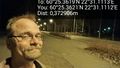
Look at that distance reading! @60.4227,22.5185
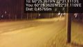
From the zero point towards east @60.4227,22.5185

