Difference between revisions of "2014-11-23 52 9"
imported>GeorgDerReisende (new expedition) |
imported>FippeBot m (Location) |
||
| (2 intermediate revisions by one other user not shown) | |||
| Line 1: | Line 1: | ||
| − | |||
| − | |||
| − | |||
| − | |||
| − | |||
| − | |||
| − | |||
| − | |||
| − | |||
| − | |||
{{meetup graticule | {{meetup graticule | ||
| lat=52 | | lat=52 | ||
| Line 18: | Line 8: | ||
__NOTOC__ | __NOTOC__ | ||
== Location == | == Location == | ||
| − | + | ||
| + | The hash lies in Hannover in the street ''Schiffgraben''. | ||
== Participants == | == Participants == | ||
| − | + | ||
| − | + | [[User:GeorgDerReisende|GeorgDerReisende]] | |
== Plans == | == Plans == | ||
| − | + | ||
| + | Hitchhiking to Hannover and walking to the hash. Arrival time unknown, latest 14:00. | ||
== Expedition == | == Expedition == | ||
| − | |||
| − | + | I started at home at 9:15 and started to hitchhike at 10:00. After 30 minutes I got a lift to Göttingen and then a lift to the service station Wülferode. From there I walked to the tram station Kronsberg. I arrived at the station Marienstraße at 13:39, then I walked to the hash. The hash lay in the street Schiffgraben on the dashed line between two lanes. Afterwards I made a walk through Hannover. | |
| − | |||
== Photos == | == Photos == | ||
| − | |||
| − | |||
| − | |||
<gallery perrow="5"> | <gallery perrow="5"> | ||
| + | Image:2014-11-23 52 9 GeorgDerReisende 0412.jpg | the hash is far | ||
| + | Image:2014-11-23 52 9 GeorgDerReisende 0438.jpg | the hash is near | ||
| + | Image:2014-11-23 52 9 GeorgDerReisende 0442.jpg | the hash lay on the second dashed line | ||
| + | Image:2014-11-23 52 9 GeorgDerReisende 0444.jpg | proof | ||
| + | Image:2014-11-23 52 9 GeorgDerReisende 0445.jpg | view to the east | ||
| + | Image:2014-11-23 52 9 GeorgDerReisende 0446.jpg | view to the west | ||
| + | Image:2014-11-23 52 9 GeorgDerReisende 0447.jpg | view to the south | ||
| + | Image:2014-11-23 52 9 GeorgDerReisende 0449.jpg | sometimes there were many cars | ||
| + | Image:2014-11-23 52 9 GeorgDerReisende 0450.jpg | proof of something like a dance | ||
| + | Image:2014-11-23 52 9 GeorgDerReisende 0463.jpg | proof of geohasher | ||
</gallery> | </gallery> | ||
| Line 44: | Line 41: | ||
<!-- Add any achievement ribbons you earned below, or remove this section --> | <!-- Add any achievement ribbons you earned below, or remove this section --> | ||
| + | {{Thumbs Up | latitude = 52 | longitude = 9 | date = 2014-11-23 | name = GeorgDerReisende }} | ||
| − | + | [[Category:Expeditions]] | |
| − | |||
| − | [[Category: | ||
| − | + | [[Category:Expeditions with photos]] | |
| − | |||
| − | |||
| − | |||
| − | [[Category: | ||
| − | |||
| − | |||
| − | |||
| − | |||
| − | |||
| − | |||
| − | |||
| − | |||
| − | |||
| − | |||
[[Category:Coordinates reached]] | [[Category:Coordinates reached]] | ||
| − | + | {{location|DE|NI|H}} | |
| − | |||
| − | |||
| − | |||
| − | |||
| − | |||
| − | |||
| − | |||
| − | |||
| − | |||
| − | |||
| − | |||
| − | |||
| − | |||
| − | |||
| − | |||
| − | |||
| − | |||
Latest revision as of 02:02, 15 August 2019
| Sun 23 Nov 2014 in 52,9: 52.3760837, 9.7521365 geohashing.info google osm bing/os kml crox |
Location
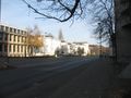
The hash lies in Hannover in the street Schiffgraben.
Participants
Plans
Hitchhiking to Hannover and walking to the hash. Arrival time unknown, latest 14:00.
Expedition
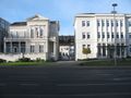
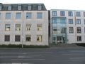
I started at home at 9:15 and started to hitchhike at 10:00. After 30 minutes I got a lift to Göttingen and then a lift to the service station Wülferode. From there I walked to the tram station Kronsberg. I arrived at the station Marienstraße at 13:39, then I walked to the hash. The hash lay in the street Schiffgraben on the dashed line between two lanes. Afterwards I made a walk through Hannover.
Photos
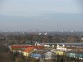
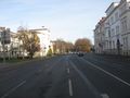
the hash is far
the hash is near
the hash lay on the second dashed line
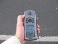
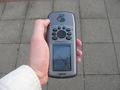
proof
view to the east
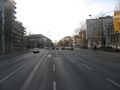
view to the west
view to the south
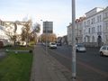
sometimes there were many cars
proof of something like a dance

proof of geohasher


Achievements
GeorgDerReisende earned the Thumbs Up Geohash Achievement
|