Difference between revisions of "2014-11-23 49 8"
imported>DODO (→Location) |
imported>FippeBot m (Location) |
||
| (7 intermediate revisions by one other user not shown) | |||
| Line 24: | Line 24: | ||
<!-- who attended: If you link to your wiki user name in this section, your expedition will be picked up by the various statistics generated for geohashing. You may use three tildes ~ as a shortcut to automatically insert the user signature of the account you are editing with. | <!-- who attended: If you link to your wiki user name in this section, your expedition will be picked up by the various statistics generated for geohashing. You may use three tildes ~ as a shortcut to automatically insert the user signature of the account you are editing with. | ||
--> | --> | ||
| + | [[User:DODO|DODO]] | ||
== Plans == | == Plans == | ||
<!-- what were the original plans --> | <!-- what were the original plans --> | ||
| + | I'll try to go there on my bull and hope to arrive around 1 pm. I have to be home early, because I'll go to the theater this evening. | ||
== Expedition == | == Expedition == | ||
<!-- how it all turned out. your narrative goes here. --> | <!-- how it all turned out. your narrative goes here. --> | ||
| + | I started with real sunny weather and had a nice trip to Heidelberg. On my way I found a new way around Ketsch, what is funny since I ride through Ketsch every day on my way to work. Shortly before I arrived in Heidelberg, some fog came up and it got cold and moist. From Heidelberg I had to climb on the Königsstuhl, 300 m above me.It was one of the first times I climbed such a long way with my bull, and I have to tell, it did a great job. Exhausted but in a very good mood I arrived at the top, looking over the dust in the rhine valley and bright sunshine up here. From here I had to go downwards again, unfortunately on a forest path so I had to go really slow. | ||
| + | |||
| + | 300 m before I reached the hash I reached a riding path where I couldn't ride. So I left my bull and walked the rest of the muddy way. I had to climb down to a ditch, cross it and climb up on the other side again. Then I left the way and walked into the steep forest. I found the hashpoint after some dancing, took several photos, left a chalk mark on a rugged tree, which was hardly readable and so I left another one on a stone. You'll find them in the pictures. | ||
| + | From now on I had to hurry because I wanted to be back home around 3 pm. I rode through Gaiberg, fell down to Leimen very fast and hurried back to Speyer. I would have been at home in time, if I wouldn't have stopped for some cake :-) | ||
== Tracklog == | == Tracklog == | ||
<!-- if your GPS device keeps a log, you may post a link here --> | <!-- if your GPS device keeps a log, you may post a link here --> | ||
| + | [http://www.gpsies.com/map.do?fileId=tqfpaqugcpgmnahn 73KM bull-riding] | ||
== Photos == | == Photos == | ||
| Line 39: | Line 46: | ||
--> | --> | ||
<gallery perrow="5"> | <gallery perrow="5"> | ||
| + | Image:2014-11-23_49_8-3.jpg | I left my bull | ||
| + | Image:2014-11-23_49_8-5.jpg | somewhere up there | ||
| + | Image:2014-11-23_49_8-6.jpg | proof | ||
| + | Image:2014-11-23_49_8-10.png | another proof | ||
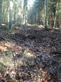
| + | Image:2014-11-23_49_8-7.jpg | view from the hashpoint - in all four directions the same | ||
| + | Image:2014-11-23_49_8-9.jpg | obligatory | ||
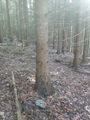
| + | Image:2014-11-23_49_8-8.jpg | mark on tree | ||
| + | Image:2014-11-23_49_8-1.jpg | mark on stone | ||
| + | Image:2014-11-23_49_8-2.jpg | two marks | ||
</gallery> | </gallery> | ||
| Line 44: | Line 60: | ||
{{#vardefine:ribbonwidth|800px}} | {{#vardefine:ribbonwidth|800px}} | ||
<!-- Add any achievement ribbons you earned below, or remove this section --> | <!-- Add any achievement ribbons you earned below, or remove this section --> | ||
| + | {{land geohash | ||
| + | | latitude = 49 | ||
| + | | longitude = 8 | ||
| + | | date = 2014-11-23 | ||
| + | | name = DODO | ||
| + | }} | ||
| − | |||
| − | |||
| − | |||
| − | |||
| − | |||
| − | |||
| − | |||
| − | |||
| − | |||
| − | |||
| − | |||
| − | |||
| − | |||
[[Category:Expeditions]] | [[Category:Expeditions]] | ||
| − | |||
[[Category:Expeditions with photos]] | [[Category:Expeditions with photos]] | ||
| − | |||
| − | |||
| − | |||
| − | |||
| − | |||
[[Category:Coordinates reached]] | [[Category:Coordinates reached]] | ||
| − | + | {{location|DE|BW|HD}} | |
| − | |||
| − | |||
| − | |||
| − | |||
| − | |||
| − | |||
| − | |||
| − | |||
| − | |||
| − | |||
| − | |||
| − | |||
| − | |||
| − | |||
| − | |||
| − | |||
| − | |||
Latest revision as of 02:02, 15 August 2019
| Sun 23 Nov 2014 in 49,8: 49.3760837, 8.7521365 geohashing.info google osm bing/os kml crox |
Location
In the forest near Gaiberg.
Participants
Plans
I'll try to go there on my bull and hope to arrive around 1 pm. I have to be home early, because I'll go to the theater this evening.
Expedition
I started with real sunny weather and had a nice trip to Heidelberg. On my way I found a new way around Ketsch, what is funny since I ride through Ketsch every day on my way to work. Shortly before I arrived in Heidelberg, some fog came up and it got cold and moist. From Heidelberg I had to climb on the Königsstuhl, 300 m above me.It was one of the first times I climbed such a long way with my bull, and I have to tell, it did a great job. Exhausted but in a very good mood I arrived at the top, looking over the dust in the rhine valley and bright sunshine up here. From here I had to go downwards again, unfortunately on a forest path so I had to go really slow.
300 m before I reached the hash I reached a riding path where I couldn't ride. So I left my bull and walked the rest of the muddy way. I had to climb down to a ditch, cross it and climb up on the other side again. Then I left the way and walked into the steep forest. I found the hashpoint after some dancing, took several photos, left a chalk mark on a rugged tree, which was hardly readable and so I left another one on a stone. You'll find them in the pictures. From now on I had to hurry because I wanted to be back home around 3 pm. I rode through Gaiberg, fell down to Leimen very fast and hurried back to Speyer. I would have been at home in time, if I wouldn't have stopped for some cake :-)
Tracklog
Photos
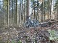
I left my bull
somewhere up there
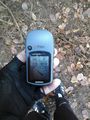
proof
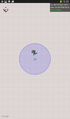
another proof
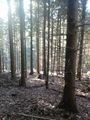
view from the hashpoint - in all four directions the same
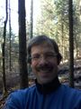
obligatory
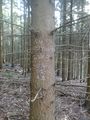
mark on tree
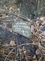
mark on stone
two marks


Achievements
DODO earned the Land geohash achievement
|