Difference between revisions of "2014-12-09 49 8"
imported>DODO (→Photos) |
imported>FippeBot m (Location) |
||
| (3 intermediate revisions by one other user not shown) | |||
| Line 40: | Line 40: | ||
== Tracklog == | == Tracklog == | ||
<!-- if your GPS device keeps a log, you may post a link here --> | <!-- if your GPS device keeps a log, you may post a link here --> | ||
| − | + | [http://www.gpsies.com/map.do?fileId=zoctljznlovruscy car 10 KM, foot 2,3 KM] | |
== Photos == | == Photos == | ||
| Line 47: | Line 47: | ||
--> | --> | ||
<gallery perrow="5"> | <gallery perrow="5"> | ||
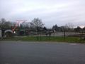
| − | + | Image:2014-12-09_49_8-1.jpg | the nearby school, seen from the second approach | |
| + | Image:2014-12-09_49_8-2.jpg | The end of the second approach | ||
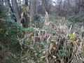
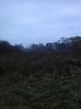
| + | Image:2014-12-09_49_8-3.jpg | The third approach: a path leading in the right direction, 119 m to go | ||
| + | Image:2014-12-09_49_8-4.jpg | 119 m later :-) | ||
| + | Image:2014-12-09_49_8-5.jpg | they got the earliest geohasher achievement... | ||
| + | Image:2014-12-09_49_8-6.jpg | ... because they had a meetup with me | ||
| + | Image:2014-12-09_49_8-7.jpg | the school seen from the hash (the path ended exactly at the hashpoint) | ||
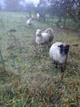
| + | Image:2014-12-09_49_8-8.jpg | lucky horses? | ||
| + | Image:2014-12-09_49_8-9.jpg | and later: not so lucky horse | ||
| + | Image:2014-12-09_49_8-10.png | another proof | ||
</gallery> | </gallery> | ||
| Line 53: | Line 62: | ||
{{#vardefine:ribbonwidth|800px}} | {{#vardefine:ribbonwidth|800px}} | ||
<!-- Add any achievement ribbons you earned below, or remove this section --> | <!-- Add any achievement ribbons you earned below, or remove this section --> | ||
| + | {{land geohash | ||
| + | | latitude = 49 | ||
| + | | longitude = 8 | ||
| + | | date = 2014-12-09 | ||
| + | | name = DODO | ||
| + | }} | ||
| − | + | {{consecutive geohash | |
| − | + | | count = 2 | |
| − | + | | latitude = 49 | |
| + | | longitude = 8 | ||
| + | | date = 2014-12-08 | ||
| + | | name = DODO | ||
| + | }} | ||
| − | |||
| − | |||
| − | |||
| − | |||
| − | |||
| − | |||
| − | |||
| − | |||
[[Category:Expeditions]] | [[Category:Expeditions]] | ||
| − | |||
[[Category:Expeditions with photos]] | [[Category:Expeditions with photos]] | ||
| − | |||
| − | |||
| − | |||
| − | |||
| − | |||
[[Category:Coordinates reached]] | [[Category:Coordinates reached]] | ||
| − | + | {{location|DE|RP|RP}} | |
| − | |||
| − | |||
| − | |||
| − | |||
| − | |||
| − | |||
| − | |||
| − | |||
| − | |||
| − | |||
| − | |||
| − | |||
| − | |||
| − | |||
| − | |||
| − | |||
| − | |||
Latest revision as of 02:08, 15 August 2019
| Tue 9 Dec 2014 in 49,8: 49.3730318, 8.3675698 geohashing.info google osm bing/os kml crox |
Location
On some fallow land next to Schifferstadt.
Participants
Plans
Visit the place on my way to the office.
Expedition
Just made the 10 KM detour on my way to work this mornig. Although I arrived some minutes past eigth, the place was very crowdy. There's a big school next to the place where I left my car and obviously school hasn't started yet. Google maps shows some sort of a path (or at least a track) from the school leading immediatly to the hashpoint, but when I walked along the school everything I found was dense scrub of blackberries. So I tried another approach, walking back to the car and taking the next path in direction of the hash. But 150 m later, I just found the same blackberry scrub. Alas, a third approach: walking all the way to the main road, then walking along the main road and enter the field from the western side.
After another KM of walking I came up to 150 m to the point, and was really lucky: a small path leading just in the right direction. I followed it and just 10m before it disappeares in the well known scrub I reached my aim. It was just next to a sheep run and so I shared my success with some curious sheep. I took some photos and headed back to my car and continued my way to the office.
All in all, 10 KM detour by car and 2,3 KM of walking.
Tracklog
Photos
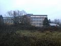
the nearby school, seen from the second approach
The end of the second approach
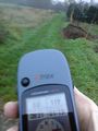
The third approach: a path leading in the right direction, 119 m to go
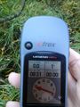
119 m later :-)
they got the earliest geohasher achievement...
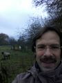
... because they had a meetup with me
the school seen from the hash (the path ended exactly at the hashpoint)
lucky horses?

and later: not so lucky horse
another proof


Achievements
DODO earned the Land geohash achievement
|
DODO earned the Consecutive geohash achievement
|