Difference between revisions of "2014-12-14 43 -121"
From Geohashing
imported>Frogman (Created page with "{{subst:Expedition |lat = 43 |lon = -121 |date = 2014-12-14 }}") |
imported>FippeBot m (Location) |
||
| (6 intermediate revisions by one other user not shown) | |||
| Line 18: | Line 18: | ||
__NOTOC__ | __NOTOC__ | ||
== Location == | == Location == | ||
| − | + | Just north of a recycling transfer station on US Hwy. 97. | |
== Participants == | == Participants == | ||
| − | + | *[[User:Frogman|Frogman]] | |
| − | + | *[[User:Benture|Benture]] | |
| − | + | *Kate | |
| − | + | *Maggie | |
| − | + | *John | |
| + | *Daisy the dog | ||
== Expedition == | == Expedition == | ||
| − | + | We weren't quite sure whether this hashpoint would be accessible via the transfer station (would it be closed that day? would they let us park there?) so instead we took nearby Sugarpine Butte Road to an NFS road which we walked on for about a mile until the hashpoint. It was cold and frosty, but it was warm in the sun. There were elk tracks frozen in the ground. | |
== Tracklog == | == Tracklog == | ||
| Line 38: | Line 39: | ||
--> | --> | ||
<gallery perrow="5"> | <gallery perrow="5"> | ||
| + | File:2014-12-14 43 -121 tree1.jpg | We saw these signs on trees. No idea what they mean. | ||
| + | File:2014-12-14 43 -121 grins.jpg | Grins! | ||
| + | File:2014-12-14 43 -121 x.jpg | This X (which was already there) marks the spot (of the hashpoint). | ||
| + | File:2014-12-14 43 -121 tree2.jpg | This tree, similar to the first one, was right by the hashpoint. | ||
| + | File:2014-12-14 43 -121 hashpoint.jpg | Hanging out. | ||
| + | File:2014-12-14 43 -121 proof.jpg | Proof! | ||
</gallery> | </gallery> | ||
| − | |||
| − | |||
| − | |||
| − | |||
| − | |||
| − | |||
| − | |||
| − | |||
| − | |||
| − | |||
| − | |||
| − | |||
| − | |||
| − | |||
| − | |||
| − | |||
[[Category:Expeditions]] | [[Category:Expeditions]] | ||
| − | |||
[[Category:Expeditions with photos]] | [[Category:Expeditions with photos]] | ||
| − | |||
| − | |||
| − | |||
| − | |||
| − | |||
[[Category:Coordinates reached]] | [[Category:Coordinates reached]] | ||
| − | + | {{location|US|OR|DE}} | |
| − | |||
| − | |||
| − | |||
| − | |||
| − | |||
| − | |||
| − | |||
| − | |||
| − | |||
| − | |||
| − | |||
| − | |||
| − | |||
| − | |||
| − | |||
| − | |||
| − | |||
Latest revision as of 02:11, 15 August 2019
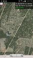
| Sun 14 Dec 2014 in 43,-121: 43.7841481, -121.4444280 geohashing.info google osm bing/os kml crox |
Location
Just north of a recycling transfer station on US Hwy. 97.
Participants
Expedition
We weren't quite sure whether this hashpoint would be accessible via the transfer station (would it be closed that day? would they let us park there?) so instead we took nearby Sugarpine Butte Road to an NFS road which we walked on for about a mile until the hashpoint. It was cold and frosty, but it was warm in the sun. There were elk tracks frozen in the ground.
Tracklog
Photos
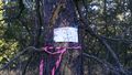
We saw these signs on trees. No idea what they mean.

Grins!
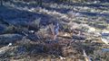
This X (which was already there) marks the spot (of the hashpoint).
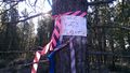
This tree, similar to the first one, was right by the hashpoint.
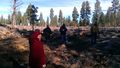
Hanging out.
Proof!


