Difference between revisions of "2014-12-31 -38 145"
imported>Kozz (Close as I could get - horses in a field) |
m (More specific location) |
||
| (8 intermediate revisions by 3 users not shown) | |||
| Line 1: | Line 1: | ||
| − | |||
| − | |||
| − | |||
| − | |||
| − | |||
| − | |||
| − | |||
| − | |||
| − | |||
| − | |||
{{meetup graticule | {{meetup graticule | ||
| lat=-38 | | lat=-38 | ||
| Line 18: | Line 8: | ||
__NOTOC__ | __NOTOC__ | ||
== Location == | == Location == | ||
| − | In a farmer's field, just outside of | + | In a farmer's field, just outside of Kernot, Pakenham, Victoria, Australia |
== Participants == | == Participants == | ||
| − | [[User:Kozz|Kozz]] | + | [[User:Kozz|Kozz]] |
== Plans == | == Plans == | ||
| Line 27: | Line 17: | ||
== Expedition == | == Expedition == | ||
| − | + | So yeah. It's been like two and a half years since my last geohash, with multiple life events along the way. I still have the Geohashing app on my phone, I knew I was heading down the Pakenham direction and could see a hash inland from Grantville and thought hey why not. | |
| + | |||
| + | I've been doing quite a lot of cycling through this region, it's beautiful rolling countryside with heaps of farmland and stands of old native bush, and in particular I've cycled past the turnoff to Kernot previously and it looked like a decent descent. So there was an element of self-interest too; understanding what would make for some decent road rides. | ||
| + | |||
| + | I left Melbourne late afternoon and headed down the freeway, then turned off at The Gurdies (specifically the Hurdy Gurdy Creek Road - didn't get a photo). | ||
| + | |||
| + | Drove up and inland through winding country roads - good condition, smooth surface, wide corners with good visibility, great countryside. Fruit trees growing on the side of the road. Curious cattle, that kinda stuff. | ||
| + | I got to the Kernot General Store, which looked interesting, then pressed on to the hashpoint. As luck would have it, it was clearly signposted with a For Sale sign. Had I won the lottery that day we'd be making a new 'property tycoon' achievement as it was pretty pleasant. the hashpoint, however, was clearly, clearly in a field occupied by a large horse, accessible only by a gate up the house driveway. I don't go out of my way to disturb livestock or to irritate farmers on New Year's Eve, so, I took my photos and left. | ||
*I got to 75 metres but it's a horse paddock. -- [[User:Kozz|Kozz]] ([[User talk:Kozz|talk]]) 20:40, 31 December 2014 (GMT+11:00) | *I got to 75 metres but it's a horse paddock. -- [[User:Kozz|Kozz]] ([[User talk:Kozz|talk]]) 20:40, 31 December 2014 (GMT+11:00) | ||
| Line 35: | Line 32: | ||
== Photos == | == Photos == | ||
| − | < | + | <gallery perrow="5"> |
| − | Image: | + | |
| − | + | Image:2014-12-31_-38_145_kozz_1420011573239.jpg | On the way to the hashpoint - stopped for a panoramic of French Island and the Western Port bay of Melbourne. | |
| − | + | ||
| + | Image:2014-12-31_-38_145_kozz_1420011216109.jpg | The place is for sale. Come on geohashers, let's crowdfund a retreat! | ||
| − | Image:2014-12-31_- | + | Image:2014-12-31_-38_145_kozz_1420011110267.jpg | Close as I could get - horses in a field preventing access. You can line up the trees in the background with the satellite photos in the screenshot. |
| − | Image:2014-12-31_- | + | Image:2014-12-31_-38_145_kozz_1420011066112.jpg | Panorama of the outlook on the other side of the road to the hashpoint. Beautiful rolling countryside, a corn field, a pond...bliss. |
| − | Image:2014-12-31_- | + | Image:2014-12-31_-38_145_kozz_1420011200000.jpg | Screenshot of locale |
</gallery> | </gallery> | ||
| Line 51: | Line 49: | ||
<!-- Add any achievement ribbons you earned below, or remove this section --> | <!-- Add any achievement ribbons you earned below, or remove this section --> | ||
| + | {{No trespassing | ||
| + | | latitude = -38 | ||
| + | | longitude = 145 | ||
| + | | date = 2014-12-31 | ||
| + | | name = [[User:Kozz|Kozz]] | ||
| + | }} | ||
| − | |||
| − | |||
| − | |||
| − | |||
| − | |||
| − | |||
| − | |||
| − | |||
| − | |||
| − | |||
| − | |||
[[Category:Expeditions]] | [[Category:Expeditions]] | ||
| − | |||
[[Category:Expeditions with photos]] | [[Category:Expeditions with photos]] | ||
| − | |||
| − | |||
| − | |||
| − | |||
| − | |||
| − | |||
| − | |||
| − | |||
| − | |||
[[Category:Coordinates not reached]] | [[Category:Coordinates not reached]] | ||
| − | |||
| − | |||
| − | |||
| − | |||
| − | |||
[[Category:Not reached - No public access]] | [[Category:Not reached - No public access]] | ||
| − | + | {{location|AU|VIC|BC}} | |
| − | |||
| − | |||
| − | |||
| − | |||
| − | |||
| − | |||
| − | |||
Latest revision as of 12:43, 1 August 2020
| Wed 31 Dec 2014 in -38,145: -38.4282043, 145.6067045 geohashing.info google osm bing/os kml crox |
Location
In a farmer's field, just outside of Kernot, Pakenham, Victoria, Australia
Participants
Kozz
Plans
Heading to Phillip Island for New Years. This is kinda on the way.
Expedition
So yeah. It's been like two and a half years since my last geohash, with multiple life events along the way. I still have the Geohashing app on my phone, I knew I was heading down the Pakenham direction and could see a hash inland from Grantville and thought hey why not.
I've been doing quite a lot of cycling through this region, it's beautiful rolling countryside with heaps of farmland and stands of old native bush, and in particular I've cycled past the turnoff to Kernot previously and it looked like a decent descent. So there was an element of self-interest too; understanding what would make for some decent road rides.
I left Melbourne late afternoon and headed down the freeway, then turned off at The Gurdies (specifically the Hurdy Gurdy Creek Road - didn't get a photo).
Drove up and inland through winding country roads - good condition, smooth surface, wide corners with good visibility, great countryside. Fruit trees growing on the side of the road. Curious cattle, that kinda stuff.
I got to the Kernot General Store, which looked interesting, then pressed on to the hashpoint. As luck would have it, it was clearly signposted with a For Sale sign. Had I won the lottery that day we'd be making a new 'property tycoon' achievement as it was pretty pleasant. the hashpoint, however, was clearly, clearly in a field occupied by a large horse, accessible only by a gate up the house driveway. I don't go out of my way to disturb livestock or to irritate farmers on New Year's Eve, so, I took my photos and left.
Tracklog
Photos
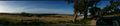
On the way to the hashpoint - stopped for a panoramic of French Island and the Western Port bay of Melbourne.
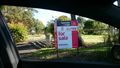
The place is for sale. Come on geohashers, let's crowdfund a retreat!
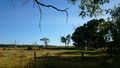
Close as I could get - horses in a field preventing access. You can line up the trees in the background with the satellite photos in the screenshot.
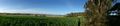
Panorama of the outlook on the other side of the road to the hashpoint. Beautiful rolling countryside, a corn field, a pond...bliss.
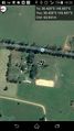
Screenshot of locale


Achievements
Kozz earned the No trespassing consolation prize
|