Difference between revisions of "2015-02-07 38 -90"
imported>Kbh3rd (Found that the meetup point was in a bison ranch) |
imported>FippeBot m (Location) |
||
| (5 intermediate revisions by one other user not shown) | |||
| Line 1: | Line 1: | ||
| − | |||
| − | |||
| − | |||
| − | |||
| − | |||
| − | |||
| − | |||
| − | |||
| − | |||
| − | |||
{{meetup graticule | {{meetup graticule | ||
| lat=38 | | lat=38 | ||
| Line 18: | Line 8: | ||
__NOTOC__ | __NOTOC__ | ||
== Location == | == Location == | ||
| − | + | In a field just off of the Hillsboro-House Springs Road in Jefferson County. | |
| − | |||
== Participants == | == Participants == | ||
| − | + | [[User:Kbh3rd|Kbh3rd]] ([[User talk:Kbh3rd|talk]]) and his lovely bride | |
| − | |||
| − | |||
== Plans == | == Plans == | ||
| − | + | Plans? Jumped in the car at the spur of the moment, it was such a beautiful day for February. Figured the best we'd do was a drive-by since these roads don't have shoulders for stopping and it was across the fence -- just -- and I don't trespass. | |
| − | |||
== Expedition == | == Expedition == | ||
| − | + | Found there was no shoulder or stopping place, as expected. Found the field inhabited by a herd of bison, which was totally unexpected. I know that there is [http://www.sayersbrook.com/ a bison ranch in Washington County], but had no idea about this one! | |
| − | + | The meetup point is in the foreground the photo of the herd of bison below, 13 meters from the geotag on the photo. Counts as reached? | |
| − | |||
== Photos == | == Photos == | ||
| − | + | Photos, taken from the window while driving past, are geotagged. | |
| − | + | ||
| − | |||
<gallery perrow="5"> | <gallery perrow="5"> | ||
| + | File:Geohashstl-20150207-016a.jpg|There was already a meetup underway... of bison. | ||
| + | File:Geohashstl-20150207-009a.jpg|Papa bison guarding the meetup point | ||
</gallery> | </gallery> | ||
| − | |||
| − | |||
| − | |||
| − | |||
| − | |||
| − | |||
| − | |||
| − | |||
| − | |||
| − | |||
| − | |||
| − | |||
| − | |||
| − | |||
[[Category:Expeditions]] | [[Category:Expeditions]] | ||
| − | |||
[[Category:Expeditions with photos]] | [[Category:Expeditions with photos]] | ||
| − | |||
| − | |||
| − | |||
| − | |||
| − | |||
[[Category:Coordinates reached]] | [[Category:Coordinates reached]] | ||
| − | + | {{location|US|MO|JE}} | |
| − | |||
| − | |||
| − | |||
| − | |||
| − | |||
| − | |||
| − | |||
| − | |||
| − | |||
| − | |||
| − | |||
| − | |||
| − | |||
| − | |||
| − | |||
| − | |||
| − | |||
| − | |||
| − | |||
| − | |||
| − | |||
| − | |||
| − | |||
Latest revision as of 00:47, 7 August 2019
| Sat 7 Feb 2015 in 38,-90: 38.3620723, -90.5619110 geohashing.info google osm bing/os kml crox |
Location
In a field just off of the Hillsboro-House Springs Road in Jefferson County.
Participants
Kbh3rd (talk) and his lovely bride
Plans
Plans? Jumped in the car at the spur of the moment, it was such a beautiful day for February. Figured the best we'd do was a drive-by since these roads don't have shoulders for stopping and it was across the fence -- just -- and I don't trespass.
Expedition
Found there was no shoulder or stopping place, as expected. Found the field inhabited by a herd of bison, which was totally unexpected. I know that there is a bison ranch in Washington County, but had no idea about this one!
The meetup point is in the foreground the photo of the herd of bison below, 13 meters from the geotag on the photo. Counts as reached?
Photos
Photos, taken from the window while driving past, are geotagged.
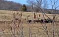
There was already a meetup underway... of bison.
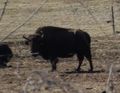
Papa bison guarding the meetup point

