Difference between revisions of "2015-02-12 49 11"
imported>Schnatterfleck (→Expedition) |
imported>FippeBot m (Location) |
||
| (3 intermediate revisions by 2 users not shown) | |||
| Line 38: | Line 38: | ||
Anyway - it took me a while longer than expected, but I already had a big grin on my face the whole time! :-) | Anyway - it took me a while longer than expected, but I already had a big grin on my face the whole time! :-) | ||
| − | The name "Worzeldorf" also rang a bell - there is a geocache that has been on my to-do-list for quite a while now. And - surprise! - it was only a few (~70) meters from the hashpoint, so | + | The name "Worzeldorf" also rang a bell - there is a geocache that has been on my to-do-list for quite a while now. And - surprise! - it was only a few (~70) meters from the hashpoint, so practically a hash collision :-)) |
The target area itself was unspectacular and easy to reach, as a little path went right through it. | The target area itself was unspectacular and easy to reach, as a little path went right through it. | ||
| Line 59: | Line 59: | ||
Image:2015-02-12_49_11_Schnatterfleck_1423748110679.jpg | Still more snow... [http://www.openstreetmap.org/?lat=49.38770000&lon=11.14090000&zoom=16&layers=B000FTF @49.3877,11.1409] | Image:2015-02-12_49_11_Schnatterfleck_1423748110679.jpg | Still more snow... [http://www.openstreetmap.org/?lat=49.38770000&lon=11.14090000&zoom=16&layers=B000FTF @49.3877,11.1409] | ||
| − | Image:2015-02-12_49_11_Schnatterfleck_1423749420423.jpg | | + | Image:2015-02-12_49_11_Schnatterfleck_1423749420423.jpg | Not too far to be a hash collision. Hashpoint somewhere in the background across the road. Standing on the stone one can see it! [http://www.openstreetmap.org/?lat=49.37740000&lon=11.10060000&zoom=16&layers=B000FTF @49.3774,11.1006] |
Image:2015-02-12_49_11_Schnatterfleck_1423749818100.jpg | Hashpoint. Nicer than expected. [http://www.openstreetmap.org/?lat=49.37720000&lon=11.09970000&zoom=16&layers=B000FTF @49.3772,11.0997] | Image:2015-02-12_49_11_Schnatterfleck_1423749818100.jpg | Hashpoint. Nicer than expected. [http://www.openstreetmap.org/?lat=49.37720000&lon=11.09970000&zoom=16&layers=B000FTF @49.3772,11.0997] | ||
| Line 77: | Line 77: | ||
| − | + | [[Category:Expeditions]] | |
| − | |||
| − | [[Category: | ||
| − | + | [[Category:Expeditions with photos]] | |
| − | |||
| − | |||
| − | |||
| − | [[Category: | ||
| − | |||
| − | |||
| − | |||
| − | |||
| − | |||
| − | |||
| − | |||
| − | |||
| − | |||
| − | |||
[[Category:Coordinates reached]] | [[Category:Coordinates reached]] | ||
| − | + | {{location|DE|BY|N}} | |
| − | |||
| − | |||
| − | |||
| − | |||
| − | |||
| − | |||
| − | |||
| − | |||
| − | |||
| − | |||
| − | |||
| − | |||
| − | |||
| − | |||
| − | |||
| − | |||
| − | |||
Latest revision as of 02:42, 15 August 2019
| Thu 12 Feb 2015 in 49,11: 49.3771296, 11.0997762 geohashing.info google osm bing/os kml crox |
Location
The edge of a wood behind the last houses of Worzeldorf.
Participants
Plans
Expedition
When I saw the location of this day's nearest Hashpoint, I got excited. Not to far from work and a really nice route that went completely through a forest. Great! Additionally I had no appointments in the afternoon, so I could take off a little early.
Riding on my bike along the forest roads was really fun! There was more snow left than I expected. Perhaps even the last snow of winter? Anyway - it took me a while longer than expected, but I already had a big grin on my face the whole time! :-)
The name "Worzeldorf" also rang a bell - there is a geocache that has been on my to-do-list for quite a while now. And - surprise! - it was only a few (~70) meters from the hashpoint, so practically a hash collision :-))
The target area itself was unspectacular and easy to reach, as a little path went right through it.
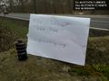
Someone had stacked some wood there, so my "The Internet was here"-Note went there.
Relaxed and happy I drove home... :-)
Tracklog
Photos
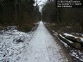
More snow and ice left on the roads than expected. @49.3938,11.1560
Still more snow... @49.3877,11.1409
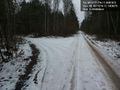
Not too far to be a hash collision. Hashpoint somewhere in the background across the road. Standing on the stone one can see it! @49.3774,11.1006
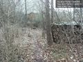
Hashpoint. Nicer than expected. @49.3772,11.0997
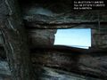
The ambassador has been here. @49.3771,11.0997
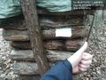
Success! @49.3771,11.0997
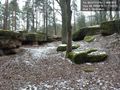
Nice old stone quarry on the way back into town. @49.3909,11.1102
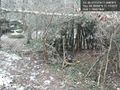
Hut of the natives? @49.3909,11.1102


