Difference between revisions of "2015-02-18 52 4"
imported>Palmpje (Created page with "{{subst:Expedition |lat = 52 |lon = 4 |date = 2015-02-18}}") |
imported>FippeBot m (Location) |
||
| (4 intermediate revisions by 2 users not shown) | |||
| Line 1: | Line 1: | ||
| − | |||
| − | |||
| − | |||
| − | |||
| − | |||
| − | |||
| − | |||
| − | |||
| − | |||
| − | |||
{{meetup graticule | {{meetup graticule | ||
| lat=52 | | lat=52 | ||
| Line 18: | Line 8: | ||
__NOTOC__ | __NOTOC__ | ||
== Location == | == Location == | ||
| − | + | ||
| + | Amsterdam, Sarphatistraat at the back of Artis Zoo. Not sure if it's on the sidewalk or inside a house. | ||
== Participants == | == Participants == | ||
<!-- who attended: If you link to your wiki user name in this section, your expedition will be picked up by the various statistics generated for geohashing. You may use three tildes ~ as a shortcut to automatically insert the user signature of the account you are editing with. | <!-- who attended: If you link to your wiki user name in this section, your expedition will be picked up by the various statistics generated for geohashing. You may use three tildes ~ as a shortcut to automatically insert the user signature of the account you are editing with. | ||
--> | --> | ||
| + | * [[User:Palmpje|Palmpje]] visited the hashpoint after work. | ||
| + | * [[User:Tchakkazulu|Tchakkazulu]] as well, joined by TheOther Guy. | ||
| + | * [[User:TheOtherGuy|TheOtherGuy]] as well, joined by Tchakkazulu. | ||
== Plans == | == Plans == | ||
<!-- what were the original plans --> | <!-- what were the original plans --> | ||
| + | === Palmpje === | ||
| + | Leave work a bit early, take subway and tram to the Muiderpoort, walk about 200m to the hashpoint and hope it's on the sidewalk. Then visit nearest geocache at 130m distance. | ||
| + | === Tchakkazulu and TheOtherGuy === | ||
| + | Tchakkazulu was planning to do this one after work, walk there, then continue walking to the central station. | ||
| + | TheOtherGuy didn't know he was going to do this until it was too late. | ||
== Expedition == | == Expedition == | ||
<!-- how it all turned out. your narrative goes here. --> | <!-- how it all turned out. your narrative goes here. --> | ||
| + | === Palmpje === | ||
| + | Everything went as planned. But was the hashpoint reached? It is hard to decide as I could not get a very good fix on the GPS. Best uncertainty distance I got on camera was 7m but it was more like 14m all the time with the tall buildings nearby. But I did see a distance of 1m to the hash with uncertainty 4m so I claim it reached. On Google maps you can't see if the point is on the sidewalk, streetview puts it right in the middle of it. So... success! | ||
| + | Because I went after work I was in my suit and tie, I only thought about the picture on the tram to the train station. I won't claim public transport because part of my commute is by car. | ||
| + | |||
| + | And of course the nearest geocache was logged. Only 130m away so honourable mention on the collision. Placing it back caused me to miss a tram (it was very busy) and therefore my train so I got home half an hour later than normal. | ||
| + | |||
| + | === Tchakkazulu and TheOtherGuy === | ||
| + | Tchakkazulu was about to leave work when TheOtherGuy called him, to see if he wanted to hang out for a bit. "Sure. Hey, today's geohash is totally walkable from work. Let's go do that." And then we were off. | ||
| + | |||
| + | We went happily on our way. Grabbed some food halfway between work and the hash, and arrived at 19:30 ish. TheOtherGuy also logged the cache not too far from here, Tchakkazulu had already logged it. Instead of walking to the central station, we took a tram, and then split up again. | ||
== Tracklog == | == Tracklog == | ||
| Line 38: | Line 47: | ||
--> | --> | ||
<gallery perrow="5"> | <gallery perrow="5"> | ||
| + | Image:2015_02_18_52_04-001.jpg | Did I walk through the houses? | ||
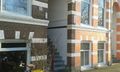
| + | Image:2015_02_18_52_04-003.jpg | Art and Artis (zoo) | ||
| + | Image:2015_02_18_52_04-004.jpg | Hashpoint | ||
| + | Image:2015_02_18_52_04-005.jpg | Mugshot | ||
| + | Image:2015_02_18_52_04-log.jpg | GC58TCQ log | ||
| + | Image:2015_02_18_52_4_Photo01_reached.png | Tchakkazulu's screenshot. | ||
</gallery> | </gallery> | ||
| Line 43: | Line 58: | ||
{{#vardefine:ribbonwidth|800px}} | {{#vardefine:ribbonwidth|800px}} | ||
<!-- Add any achievement ribbons you earned below, or remove this section --> | <!-- Add any achievement ribbons you earned below, or remove this section --> | ||
| + | {{land geohash | latitude = 52 | longitude = 4 | date = 2015-02-18 | name = Palmpje }} | ||
| + | {{Formal attire | latitude = 52 | longitude = 4 | date = 2015-02-18 | name = Palmpje }} | ||
| + | {{Hash collision | latitude = 52 | longitude = 4 | date = 2015-02-18 | name = Palmpje | id = GC58TCQ | distance = 130 meter | honor = honorable mention}} | ||
| − | |||
| − | |||
| − | |||
| − | |||
| − | |||
| − | |||
| − | |||
| − | |||
| − | |||
| − | |||
| − | |||
| − | |||
[[Category:Expeditions]] | [[Category:Expeditions]] | ||
| − | |||
[[Category:Expeditions with photos]] | [[Category:Expeditions with photos]] | ||
| − | |||
| − | |||
| − | |||
| − | |||
| − | |||
[[Category:Coordinates reached]] | [[Category:Coordinates reached]] | ||
| − | + | {{location|NL|NH}} | |
| − | |||
| − | |||
| − | |||
| − | |||
| − | |||
| − | |||
| − | |||
| − | |||
| − | |||
| − | |||
| − | |||
| − | |||
| − | |||
| − | |||
| − | |||
| − | |||
| − | |||
Latest revision as of 02:47, 15 August 2019
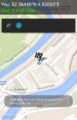
| Wed 18 Feb 2015 in 52,4: 52.3644602, 4.9208611 geohashing.info google osm bing/os kml crox |
Location
Amsterdam, Sarphatistraat at the back of Artis Zoo. Not sure if it's on the sidewalk or inside a house.
Participants
- Palmpje visited the hashpoint after work.
- Tchakkazulu as well, joined by TheOther Guy.
- TheOtherGuy as well, joined by Tchakkazulu.
Plans
Palmpje
Leave work a bit early, take subway and tram to the Muiderpoort, walk about 200m to the hashpoint and hope it's on the sidewalk. Then visit nearest geocache at 130m distance.
Tchakkazulu and TheOtherGuy
Tchakkazulu was planning to do this one after work, walk there, then continue walking to the central station. TheOtherGuy didn't know he was going to do this until it was too late.
Expedition
Palmpje
Everything went as planned. But was the hashpoint reached? It is hard to decide as I could not get a very good fix on the GPS. Best uncertainty distance I got on camera was 7m but it was more like 14m all the time with the tall buildings nearby. But I did see a distance of 1m to the hash with uncertainty 4m so I claim it reached. On Google maps you can't see if the point is on the sidewalk, streetview puts it right in the middle of it. So... success! Because I went after work I was in my suit and tie, I only thought about the picture on the tram to the train station. I won't claim public transport because part of my commute is by car.
And of course the nearest geocache was logged. Only 130m away so honourable mention on the collision. Placing it back caused me to miss a tram (it was very busy) and therefore my train so I got home half an hour later than normal.
Tchakkazulu and TheOtherGuy
Tchakkazulu was about to leave work when TheOtherGuy called him, to see if he wanted to hang out for a bit. "Sure. Hey, today's geohash is totally walkable from work. Let's go do that." And then we were off.
We went happily on our way. Grabbed some food halfway between work and the hash, and arrived at 19:30 ish. TheOtherGuy also logged the cache not too far from here, Tchakkazulu had already logged it. Instead of walking to the central station, we took a tram, and then split up again.
Tracklog
Photos
Did I walk through the houses?

Art and Artis (zoo)
Hashpoint
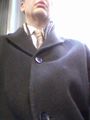
Mugshot
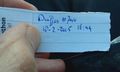
GC58TCQ log
Tchakkazulu's screenshot.


Achievements
Palmpje earned the Land geohash achievement
|
Palmpje earned the Formal attire achievement
|
Palmpje earned the Hash collision honorable mention
|