Difference between revisions of "2015-03-06 51 9"
From Geohashing
imported>GeorgDerReisende (new expedition) |
imported>FippeBot m (Location) |
||
| (3 intermediate revisions by one other user not shown) | |||
| Line 1: | Line 1: | ||
| − | |||
| − | |||
| − | |||
| − | |||
| − | |||
| − | |||
| − | |||
| − | |||
| − | |||
| − | |||
{{meetup graticule | {{meetup graticule | ||
| lat=51 | | lat=51 | ||
| Line 19: | Line 9: | ||
== Location == | == Location == | ||
<!-- where you've surveyed the hash to be --> | <!-- where you've surveyed the hash to be --> | ||
| + | |||
| + | lat.38981, lon.33415: at the edge of a forest west of Calden-Ehrsten | ||
| + | |||
| + | === calculating coordinates === | ||
| + | |||
| + | for east of W30 | ||
| + | |||
| + | I use http://elmar-eigner.de/md5_maker.html for the calculating of the md5 and http://www.easysurf.cc/cnver17.htm#bf16tobf10 for the calculating of the decimal fractions. | ||
| + | |||
| + | {| class="wikitable" | ||
| + | |- | ||
| + | | 2015-03-06-18096.90 || 63cb32483a884d83 || 558b32588073be22 || lat.38981928122896753 || lon.33415522251784946 | ||
| + | |} | ||
| + | |||
== Participants == | == Participants == | ||
| − | + | ||
| − | + | [[User:GeorgDerReisende|GeorgDerReisende]] | |
== Plans == | == Plans == | ||
| − | + | ||
| + | Going by bus to Ehrsten and walking to the hash. | ||
== Expedition == | == Expedition == | ||
| − | + | ||
| + | I went to Ehrsten by tram and buses: 3, 100, 46. Then I walked through the fields to the hash. It was at the edge of the forest. I took some photos and went home. | ||
== Tracklog == | == Tracklog == | ||
| Line 34: | Line 40: | ||
== Photos == | == Photos == | ||
| − | |||
| − | |||
| − | |||
<gallery perrow="5"> | <gallery perrow="5"> | ||
| + | Image:2015-03-06 51 9 GeorgDerReisende 2548.jpg | Arrived in Ehrsten. | ||
| + | Image:2015-03-06 51 9 GeorgDerReisende 2551.jpg | First view to the hash. | ||
| + | Image:2015-03-06 51 9 GeorgDerReisende 2556.jpg | Muddy field way. | ||
| + | Image:2015-03-06 51 9 GeorgDerReisende 2559.jpg | First shot. | ||
| + | Image:2015-03-06 51 9 GeorgDerReisende 2560.jpg | Or here? | ||
| + | Image:2015-03-06 51 9 GeorgDerReisende 2561.jpg | Or beyond here? | ||
| + | Image:2015-03-06 51 9 GeorgDerReisende 2565.jpg | Found. | ||
| + | Image:2015-03-06 51 9 GeorgDerReisende 2566.jpg | Proof of dance. | ||
| + | Image:2015-03-06 51 9 GeorgDerReisende 2567.jpg | West. Into the forest. | ||
| + | Image:2015-03-06 51 9 GeorgDerReisende 2568.jpg | North. | ||
| + | Image:2015-03-06 51 9 GeorgDerReisende 2569.jpg | East. And Ehrsten. | ||
| + | Image:2015-03-06 51 9 GeorgDerReisende 2571.jpg | Geohasher. | ||
| + | Image:2015-03-06 51 9 GeorgDerReisende 2572.jpg | South. | ||
| + | Image:2015-03-06 51 9 GeorgDerReisende 2574.jpg | Northeast. View to [[2015-03-05 51 9]]. On the hill in the back. | ||
</gallery> | </gallery> | ||
| Line 44: | Line 61: | ||
<!-- Add any achievement ribbons you earned below, or remove this section --> | <!-- Add any achievement ribbons you earned below, or remove this section --> | ||
| + | {{Public transport geohash | latitude = 51 | longitude = 9 | date = 2015-03-06 | busline = tram 3, buses 100 and 46 | name = GeorgDerReisende }} | ||
| − | + | [[Category:Expeditions]] | |
| − | |||
| − | [[Category: | ||
| − | + | [[Category:Expeditions with photos]] | |
| − | |||
| − | |||
| − | |||
| − | |||
| − | |||
| − | |||
| − | |||
| − | |||
| − | |||
| − | |||
| − | |||
| − | |||
| − | |||
| − | |||
[[Category:Coordinates reached]] | [[Category:Coordinates reached]] | ||
| − | + | {{location|DE|HE|KS}} | |
| − | |||
| − | |||
| − | |||
| − | |||
| − | |||
| − | |||
| − | |||
| − | |||
| − | |||
| − | |||
| − | |||
| − | |||
| − | |||
| − | |||
| − | |||
| − | |||
| − | |||
Latest revision as of 02:56, 15 August 2019
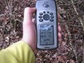
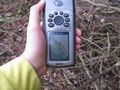
| Fri 6 Mar 2015 in 51,9: 51.3898193, 9.3341552 geohashing.info google osm bing/os kml crox |
Location
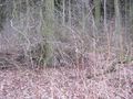
lat.38981, lon.33415: at the edge of a forest west of Calden-Ehrsten
calculating coordinates
for east of W30
I use http://elmar-eigner.de/md5_maker.html for the calculating of the md5 and http://www.easysurf.cc/cnver17.htm#bf16tobf10 for the calculating of the decimal fractions.
| 2015-03-06-18096.90 | 63cb32483a884d83 | 558b32588073be22 | lat.38981928122896753 | lon.33415522251784946 |
Participants
Plans
Going by bus to Ehrsten and walking to the hash.
Expedition
I went to Ehrsten by tram and buses: 3, 100, 46. Then I walked through the fields to the hash. It was at the edge of the forest. I took some photos and went home.
Tracklog
Photos
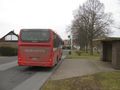
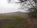
Arrived in Ehrsten.
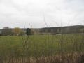
First view to the hash.
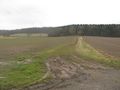
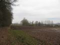
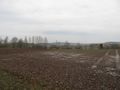
Muddy field way.
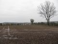
First shot.
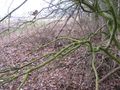
Or here?
Or beyond here?
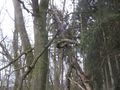
Found.
Proof of dance.
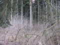
West. Into the forest.
North.
East. And Ehrsten.
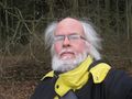
Geohasher.
South.
Northeast. View to 2015-03-05 51 9. On the hill in the back.


Achievements
GeorgDerReisende earned the Public transport geohash achievement
|