Difference between revisions of "2015-03-13 49 8"
imported>Q-Owl m (→Expedition) |
imported>FippeBot m (Location) |
||
| (One intermediate revision by one other user not shown) | |||
| Line 22: | Line 22: | ||
I drove home after work and drove together with my wife to [http://de.wikipedia.org/wiki/Maudach Maudach], a little village and part of [[wikipedia:Ludwigshafen|Ludwigshafen]]. The hashpoint lay in the middle of the [http://de.wikipedia.org/wiki/Maudacher_Bruch Maudacher Bruch] which is a dry swamp/moor, situated in a former curve of the river Rhine (see [https://www.youtube.com/watch?v=p7L1mzdO-wQ youtube.com]). | I drove home after work and drove together with my wife to [http://de.wikipedia.org/wiki/Maudach Maudach], a little village and part of [[wikipedia:Ludwigshafen|Ludwigshafen]]. The hashpoint lay in the middle of the [http://de.wikipedia.org/wiki/Maudacher_Bruch Maudacher Bruch] which is a dry swamp/moor, situated in a former curve of the river Rhine (see [https://www.youtube.com/watch?v=p7L1mzdO-wQ youtube.com]). | ||
| − | We arrived after sunset and had a 1.5 km walk in dusk and ugly cold northwind to the hashpoint. It was easy to find (about 19:00 h) on a field, I took some | + | We arrived after sunset and had a 1.5 km walk in dusk and ugly cold northwind to the hashpoint. It was easy to find (about 19:00 h) on a field, I took some photos and we walked back to the car. And we did the earthcache [http://coord.info/GC4230Z GC4230Z] there. |
Edit:<br>As [[User:Eupeodes|Eupeodes]] wrote, there are some Problems with the coordinates today.<br>It seems that the coordinates, my smartphone displayed, are the right ones. | Edit:<br>As [[User:Eupeodes|Eupeodes]] wrote, there are some Problems with the coordinates today.<br>It seems that the coordinates, my smartphone displayed, are the right ones. | ||
| Line 87: | Line 87: | ||
[[Category: Meetup on 2015-03-13]] | [[Category: Meetup on 2015-03-13]] | ||
[[Category: Meetup in 49 8]]--> | [[Category: Meetup in 49 8]]--> | ||
| + | {{location|DE|RP|LU}} | ||
Latest revision as of 03:00, 15 August 2019

| Fri 13 Mar 2015 in 49,8: 49.4676646, 8.3849940 geohashing.info google osm bing/os kml crox |
Location
In the middle of the Maudacher Bruch near Ludwigshafen.
Participants
Plan
Drive by car to the hash area after work and walk to the hashpoint.
Expedition
I drove home after work and drove together with my wife to Maudach, a little village and part of Ludwigshafen. The hashpoint lay in the middle of the Maudacher Bruch which is a dry swamp/moor, situated in a former curve of the river Rhine (see youtube.com).
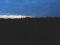
We arrived after sunset and had a 1.5 km walk in dusk and ugly cold northwind to the hashpoint. It was easy to find (about 19:00 h) on a field, I took some photos and we walked back to the car. And we did the earthcache GC4230Z there.
Edit:
As Eupeodes wrote, there are some Problems with the coordinates today.
It seems that the coordinates, my smartphone displayed, are the right ones.
Photos
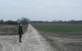
Walk to the hashpoint and view north
Proof
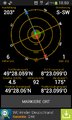
The hp lies there in the west
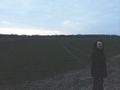
At the hp: View north
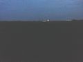
View west

Grin in the dark


Achievements / Honorable Mention
Q-Owl earned the Land geohash achievement
|