Difference between revisions of "2015-04-05 49 9"
imported>DODO (→Location) |
imported>FippeBot m (Location) |
||
| (9 intermediate revisions by one other user not shown) | |||
| Line 24: | Line 24: | ||
<!-- who attended: If you link to your wiki user name in this section, your expedition will be picked up by the various statistics generated for geohashing. You may use three tildes ~ as a shortcut to automatically insert the user signature of the account you are editing with. | <!-- who attended: If you link to your wiki user name in this section, your expedition will be picked up by the various statistics generated for geohashing. You may use three tildes ~ as a shortcut to automatically insert the user signature of the account you are editing with. | ||
--> | --> | ||
| + | [[User:DODO|DODO]] | ||
== Plans == | == Plans == | ||
| Line 30: | Line 31: | ||
== Expedition == | == Expedition == | ||
<!-- how it all turned out. your narrative goes here. --> | <!-- how it all turned out. your narrative goes here. --> | ||
| + | Number two in this years bicycle hash tour (to number [[2015-04-04_48_9|one]] and [[2015-04-06_48_9|three]]). | ||
| + | |||
| + | As I was still totally exhausted from yesterday, I decided for the nearer and easier to reach hashpoint today. | ||
| + | |||
| + | I could hardly believe what I saw, when I woke up: The weather was sunny today, although it was pretty cold, especially, when I shot down the Gablenberger Weg down again back to the city of Stuttgart (in reality it was much to steep to ride fast, as I could never have stopped the bike in time if anything would have happened). Some minutes later I reached the Neckar and followed that river for a while (and crossed it five times, I have no idea why my routing program told me so). Before I reached Marbach I cut of a bow of the river and earned my first moderate climbing for today. | ||
| + | |||
| + | [http://en.wikipedia.org/wiki/Friedrich_Schiller Schiller] was born in Marbach and so the Deutsche Literaturarchiv (german federal archive of literature) is situated there. So I wanted to have a break here but after I cycled through the city center for five minutes I decided that it was to early on the day to do so, as I guess that I have seen most of the town (of course I could have visited the museum, but that would have needed more time than I wanted to spend). | ||
| + | |||
| + | In Marbach I left the Neckar and crossed some hills to get to Steinheim an der Murr: From here I didn't follow the river Murr but went along a rivulet with an even funnier name, the Bottwar. Although I'd never heard of this before, the valley was very picturesque, with a lot of vine, many castles and nice villages. I decided to have my break in one of them, Beilstein, and have a picnic below the associated castle. Consolidated I tackled the last part of my ride. I left the Bottwar and followed a small ditch named Gruppenbach that ended (or started respectively) in a steep forest. On the top of the hill I had to switch to a forestial path to go downhill again. The second slow descent for today. When I left the forest it was only some 500m to hash (steep upwards again of course). | ||
| + | |||
| + | I reached a nice vineyard, which I had to enter for 20 meters to reach the point. I took some pictures, left a mark and had a little picnic outside of the vineyard again. | ||
| + | |||
| + | I waited for a while but didn't expect anyone else to come, so I left again. Funny enough, just 500 m from the hash I again found a hotel in the middle of nowhere, where I stayed the night. I had a nice easter dinner there with a marvelous view over the city of Weinsberg and to the castle Weibertreu ("womens faith", for the legend see [http://www.pitt.edu/~dash/type0875ast.html#weinsberg here]). | ||
== Tracklog == | == Tracklog == | ||
<!-- if your GPS device keeps a log, you may post a link here --> | <!-- if your GPS device keeps a log, you may post a link here --> | ||
| + | [https://www.komoot.de/tour/4503404 61 KM by bike] | ||
== Photos == | == Photos == | ||
| Line 39: | Line 54: | ||
--> | --> | ||
<gallery perrow="5"> | <gallery perrow="5"> | ||
| + | Image: 2015-04-05_49_9-1.jpg|along the Neckar | ||
| + | Image: 2015-04-05_49_9-2.jpg|Deutsches Literaturarchiv | ||
| + | Image: 2015-04-05_49_9-3.jpg|a fountain in Marbach | ||
| + | Image: 2015-04-05_49_9-5.jpg|Schiller was born here | ||
| + | Image: 2015-04-05_49_9-6.jpg|a castle and my bike at the Bottwar | ||
| + | Image: 2015-04-05_49_9-7.jpg|the castle of Beilstein | ||
| + | Image: 2015-04-05_49_9-8.jpg|Beilstein seen from the castle | ||
| + | Image: 2015-04-05_49_9-10.jpg|left my bike near the hash | ||
| + | Image: 2015-04-05_49_9-9.jpg|one proof (zero!) | ||
| + | Image: 2015-04-05_49_9-16.png|another proof | ||
| + | Image: 2015-04-05_49_9-11.jpg|view from the hash to the south... | ||
| + | Image: 2015-04-05_49_9-12.jpg|... the north... | ||
| + | Image: 2015-04-05_49_9-13.jpg|...the west... | ||
| + | Image: 2015-04-05_49_9-14.jpg|...and the hasher. | ||
| + | Image: 2015-04-05_49_9-15.jpg|mark | ||
</gallery> | </gallery> | ||
| Line 44: | Line 74: | ||
{{#vardefine:ribbonwidth|800px}} | {{#vardefine:ribbonwidth|800px}} | ||
<!-- Add any achievement ribbons you earned below, or remove this section --> | <!-- Add any achievement ribbons you earned below, or remove this section --> | ||
| + | {{land geohash | ||
| + | | latitude = 49 | ||
| + | | longitude =9 | ||
| + | | date = 2015-04-05 | ||
| + | | name = DODO | ||
| + | }} | ||
| + | {{bicycle geohash | ||
| + | | latitude = 49 | ||
| + | | longitude = 9 | ||
| + | | date = 2015-04-05 | ||
| + | | name = DODO | ||
| + | | distance = 61 KM | ||
| + | }} | ||
| − | + | {{consecutive geohash | |
| − | + | | count = 2 | |
| − | + | | latitude = 48 | |
| + | | longitude = 9 | ||
| + | | date = 2015-04-04 | ||
| + | | name = DODO | ||
| + | }} | ||
| − | |||
| − | |||
| − | |||
| − | |||
| − | |||
| − | |||
| − | |||
[[Category:Expeditions]] | [[Category:Expeditions]] | ||
| − | |||
[[Category:Expeditions with photos]] | [[Category:Expeditions with photos]] | ||
| − | |||
| − | |||
| − | |||
| − | |||
| − | |||
[[Category:Coordinates reached]] | [[Category:Coordinates reached]] | ||
| − | + | {{location|DE|BW|HN}} | |
| − | |||
| − | |||
| − | |||
| − | |||
| − | |||
| − | |||
| − | |||
| − | |||
| − | |||
| − | |||
| − | |||
| − | |||
| − | |||
| − | |||
| − | |||
| − | |||
| − | |||
Latest revision as of 03:13, 15 August 2019
| Sun 5 Apr 2015 in 49,9: 49.1333651, 9.2982086 geohashing.info google osm bing/os kml crox |
Location
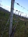
In a vineyard above Weinsberg (opposite to Burg Weibertreu).
Participants
Plans
Expedition
Number two in this years bicycle hash tour (to number one and three).
As I was still totally exhausted from yesterday, I decided for the nearer and easier to reach hashpoint today.
I could hardly believe what I saw, when I woke up: The weather was sunny today, although it was pretty cold, especially, when I shot down the Gablenberger Weg down again back to the city of Stuttgart (in reality it was much to steep to ride fast, as I could never have stopped the bike in time if anything would have happened). Some minutes later I reached the Neckar and followed that river for a while (and crossed it five times, I have no idea why my routing program told me so). Before I reached Marbach I cut of a bow of the river and earned my first moderate climbing for today.
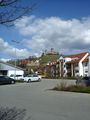
Schiller was born in Marbach and so the Deutsche Literaturarchiv (german federal archive of literature) is situated there. So I wanted to have a break here but after I cycled through the city center for five minutes I decided that it was to early on the day to do so, as I guess that I have seen most of the town (of course I could have visited the museum, but that would have needed more time than I wanted to spend).
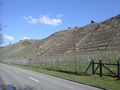
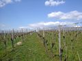
In Marbach I left the Neckar and crossed some hills to get to Steinheim an der Murr: From here I didn't follow the river Murr but went along a rivulet with an even funnier name, the Bottwar. Although I'd never heard of this before, the valley was very picturesque, with a lot of vine, many castles and nice villages. I decided to have my break in one of them, Beilstein, and have a picnic below the associated castle. Consolidated I tackled the last part of my ride. I left the Bottwar and followed a small ditch named Gruppenbach that ended (or started respectively) in a steep forest. On the top of the hill I had to switch to a forestial path to go downhill again. The second slow descent for today. When I left the forest it was only some 500m to hash (steep upwards again of course).
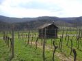
I reached a nice vineyard, which I had to enter for 20 meters to reach the point. I took some pictures, left a mark and had a little picnic outside of the vineyard again.
I waited for a while but didn't expect anyone else to come, so I left again. Funny enough, just 500 m from the hash I again found a hotel in the middle of nowhere, where I stayed the night. I had a nice easter dinner there with a marvelous view over the city of Weinsberg and to the castle Weibertreu ("womens faith", for the legend see here).
Tracklog
Photos
along the Neckar
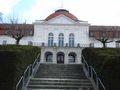
Deutsches Literaturarchiv
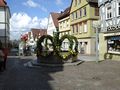
a fountain in Marbach
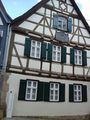
Schiller was born here
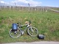
a castle and my bike at the Bottwar
the castle of Beilstein
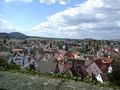
Beilstein seen from the castle
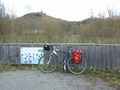
left my bike near the hash
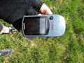
one proof (zero!)
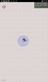
another proof
view from the hash to the south...
... the north...
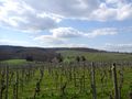
...the west...
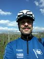
...and the hasher.
mark


Achievements
DODO earned the Land geohash achievement
|
DODO earned the Bicycle geohash achievement
|
DODO earned the Consecutive geohash achievement
|