Difference between revisions of "2015-04-08 48 10"
imported>DODO (→Achievements) |
(restoring older version) |
||
| (11 intermediate revisions by 4 users not shown) | |||
| Line 31: | Line 31: | ||
== Expedition == | == Expedition == | ||
<!-- how it all turned out. your narrative goes here. --> | <!-- how it all turned out. your narrative goes here. --> | ||
| − | Number five in this years bicycle hash tour (to number [[2015-04-07_48_11|four]]. | + | Number five in this years bicycle hash tour (to number [[2015-04-07_48_11|four]]). |
| − | I | + | Meanwhile I was pretty far from home and obviously had to use a train to get home today. But I was surprised, that it would take me almost 6 hours to get home by train. But I have to visit a hashpoint on my journey. Well, the closest point to my way is 48_10, and so I will interrupt the journey for a bicycle ride. (By the way, just when I'm away from home and in holiday, the "home"-point is so close to my office that I could walk) |
| − | + | So I reached the station in Dillingen for the 9:46-train to Ulm. An hour later I left the train in Dillingen and cycled southwards. I had three hours of time to reach the hash and continue to Günzburg, where I could finish the ride to Ulm at 14:16. The ride was rather uneventful through the hilly bavarian landscape. After 1:30 I reached the B10 and had just 3 more kilometers to go. Soon I found the forest path that came next to my target. I left the bike there and found a deer pass that went in the wanted direction. I remembered that the hash was nearly halfway between Dillingen and Ginzburg, and so I started to hurry a little. I had forgotten to load the coordinates to my bps-device, so hashdroid had to do.GPS-reception was poor in the forest, and so I had to dance for a while before I got a satisfying picture. A quick chalk mar k later I walked bake to my bike and continued to Ginzburg. I reached the station at 2 o'clock and finished the journey with four and a half more hours in different trains and stations (Ulm, Stuttgart, Karlsruhe, Speyer). | |
== Tracklog == | == Tracklog == | ||
<!-- if your GPS device keeps a log, you may post a link here --> | <!-- if your GPS device keeps a log, you may post a link here --> | ||
| + | [https://www.komoot.de/tour/4547104 49 KM by bike from Dillingen to Günzburg] | ||
| + | |||
| + | [http://www.gpsies.com/map.do?fileId=ghyonurtlmjekqrw 55 km by bike altogether and 311 km by train] | ||
== Photos == | == Photos == | ||
| Line 45: | Line 48: | ||
--> | --> | ||
<gallery perrow="5"> | <gallery perrow="5"> | ||
| + | Image:2015-04-08_48_10-9.png|In the end I got a good shot | ||
| + | Image:2015-04-08_48_10-1.jpg|view to south | ||
| + | Image:2015-04-08_48_10-2.jpg|west | ||
| + | Image:2015-04-08_48_10-3.jpg|and east | ||
| + | Image:2015-04-08_48_10-4.jpg|the deer pass I followed | ||
| + | Image:2015-04-08_48_10-5.jpg|stupid grin | ||
| + | Image:2015-04-08_48_10-6.jpg|a mark | ||
| + | Image:2015-04-08_48_10-8.jpg|and my bicycle once again in the end | ||
</gallery> | </gallery> | ||
| Line 51: | Line 62: | ||
<!-- Add any achievement ribbons you earned below, or remove this section --> | <!-- Add any achievement ribbons you earned below, or remove this section --> | ||
| + | {{land geohash | ||
| + | | latitude = 48 | ||
| + | | longitude =10 | ||
| + | | date = 2015-04-08 | ||
| + | | name = DODO | ||
| + | }} | ||
| + | |||
| + | {{Public transport geohash | ||
| + | | latitude = 48 | ||
| + | | longitude = 10 | ||
| + | | date = 2015-04-08 | ||
| + | | name = DODO | ||
| + | }} | ||
| + | |||
| + | {{Minesweeper geohash | ||
| + | | graticule = Würzburg, Germany | ||
| + | | ranknumber = 5 | ||
| + | | nw = true | ||
| + | | w = true | ||
| + | | sw = true | ||
| + | | s = true | ||
| + | | se=true | ||
| + | | name = DODO | ||
| + | }} | ||
| + | {{consecutive geohash | ||
| + | | count = 5 | ||
| + | | latitude = 48 | ||
| + | | longitude = 9 | ||
| + | | date = 2015-04-04 | ||
| + | | name = DODO | ||
| + | }} | ||
[[Category:Expeditions]] | [[Category:Expeditions]] | ||
[[Category:Expeditions with photos]] | [[Category:Expeditions with photos]] | ||
[[Category:Coordinates reached]] | [[Category:Coordinates reached]] | ||
| + | {{location|DE|BY|A}} | ||
Latest revision as of 16:04, 29 December 2021
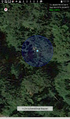
| Wed 8 Apr 2015 in 48,10: 48.4231870, 10.5424993 geohashing.info google osm bing/os kml crox |
Location
In the forest west of Landensberg, just north of the B10.
Participants
Plans
Expedition
Number five in this years bicycle hash tour (to number four).
Meanwhile I was pretty far from home and obviously had to use a train to get home today. But I was surprised, that it would take me almost 6 hours to get home by train. But I have to visit a hashpoint on my journey. Well, the closest point to my way is 48_10, and so I will interrupt the journey for a bicycle ride. (By the way, just when I'm away from home and in holiday, the "home"-point is so close to my office that I could walk)
So I reached the station in Dillingen for the 9:46-train to Ulm. An hour later I left the train in Dillingen and cycled southwards. I had three hours of time to reach the hash and continue to Günzburg, where I could finish the ride to Ulm at 14:16. The ride was rather uneventful through the hilly bavarian landscape. After 1:30 I reached the B10 and had just 3 more kilometers to go. Soon I found the forest path that came next to my target. I left the bike there and found a deer pass that went in the wanted direction. I remembered that the hash was nearly halfway between Dillingen and Ginzburg, and so I started to hurry a little. I had forgotten to load the coordinates to my bps-device, so hashdroid had to do.GPS-reception was poor in the forest, and so I had to dance for a while before I got a satisfying picture. A quick chalk mar k later I walked bake to my bike and continued to Ginzburg. I reached the station at 2 o'clock and finished the journey with four and a half more hours in different trains and stations (Ulm, Stuttgart, Karlsruhe, Speyer).
Tracklog
49 KM by bike from Dillingen to Günzburg
55 km by bike altogether and 311 km by train
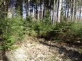
Photos
In the end I got a good shot
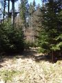
view to south
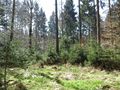
west
and east
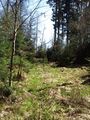
the deer pass I followed
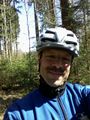
stupid grin
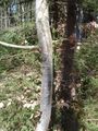
a mark
and my bicycle once again in the end


Achievements
DODO earned the Land geohash achievement
|
DODO earned the Public transport geohash achievement
|
DODO achieved level 5 of the Minesweeper Geohash achievement
|
DODO earned the Consecutive geohash achievement
|