Difference between revisions of "2015-04-18 49 8"
imported>DODO (→Tracklog) |
imported>FippeBot m (Location) |
||
| (3 intermediate revisions by one other user not shown) | |||
| Line 38: | Line 38: | ||
== Tracklog == | == Tracklog == | ||
<!-- if your GPS device keeps a log, you may post a link here --> | <!-- if your GPS device keeps a log, you may post a link here --> | ||
| − | [http://www.gpsies.com/map.do?fileId=dccacihhunydrdul 67 KM by bull] | + | [http://www.gpsies.com/map.do?fileId=dccacihhunydrdul 67 KM by bull], tron by the way |
== Photos == | == Photos == | ||
| Line 45: | Line 45: | ||
--> | --> | ||
<gallery perrow="5"> | <gallery perrow="5"> | ||
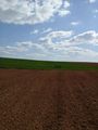
| + | Image:2015-04-18_49_8-1.jpg|the first view to the hash. It's on the ploughed field behind the green one. | ||
| + | Image:2015-04-18_49_8-2.jpg|there, 30m in this direction | ||
| + | Image:2015-04-18_49_8-3.jpg|I left my bull alone | ||
| + | Image:2015-04-18_49_8-4.jpg|proof | ||
| + | Image:2015-04-18_49_8-5.jpg|I should improve my grinning. But so it looks stupid at least | ||
| + | Image:2015-04-18_49_8-6.jpg|to the east | ||
| + | Image:2015-04-18_49_8-7.jpg|north | ||
| + | Image:2015-04-18_49_8-8.jpg|west | ||
| + | Image:2015-04-18_49_8-9.jpg|and bull | ||
| + | Image:2015-04-18_49_8-10.jpg|Another peace of history. During WW II there was a railway through Sellheim to transport munition to the french border | ||
</gallery> | </gallery> | ||
| Line 50: | Line 60: | ||
{{#vardefine:ribbonwidth|800px}} | {{#vardefine:ribbonwidth|800px}} | ||
<!-- Add any achievement ribbons you earned below, or remove this section --> | <!-- Add any achievement ribbons you earned below, or remove this section --> | ||
| + | {{land geohash | ||
| + | | latitude = 49 | ||
| + | | longitude = 8 | ||
| + | | date = 2015-04-18 | ||
| + | | name = DODO | ||
| + | }} | ||
| + | {{Template:Tron | ||
| + | | latitude = 49 | ||
| + | | longitude = 8 | ||
| + | | date = 2015-04-18 | ||
| + | | name = DODO | ||
| + | | possessive = his | ||
| + | | tracklog = http://www.gpsies.com/map.do?fileId=dccacihhunydrdul | ||
| + | }} | ||
| − | |||
| − | |||
| − | |||
| − | |||
| − | |||
| − | |||
| − | |||
| − | |||
| − | |||
| − | |||
[[Category:Expeditions]] | [[Category:Expeditions]] | ||
| − | |||
[[Category:Expeditions with photos]] | [[Category:Expeditions with photos]] | ||
| − | |||
| − | |||
| − | |||
| − | |||
| − | |||
[[Category:Coordinates reached]] | [[Category:Coordinates reached]] | ||
| − | + | {{location|DE|RP|SÜW}} | |
| − | |||
| − | |||
| − | |||
| − | |||
| − | |||
| − | |||
| − | |||
| − | |||
| − | |||
| − | |||
| − | |||
| − | |||
| − | |||
| − | |||
| − | |||
| − | |||
| − | |||
Latest revision as of 03:24, 15 August 2019
| Sat 18 Apr 2015 in 49,8: 49.1620383, 8.1700695 geohashing.info google osm bing/os kml crox |
Location
On a field near Inseam, southeast of Landau
Participants
Plans
Go there with my bull in the sunny weather. I will start soon, so I hope to be there around 3 o'clock. That's a little bit early for a meetup, but I can't come later.
Expedition
Everything went almost as planned. The sun was shining bright today, but there was a cold wind. That was fun on my way to the hash as the wind comes from the rear and so I reached the hash almost exactly an hour after I left home. On my way I found some new corners of Herxheim and some coffee shops that I didn't know. But as I made a cake this morning by myself, I did not stop there.
500m before the hash I had to switch on an earth road which was very uneven. The hash lies in a depression with several fields in it. My one was an ploughed but dry one. I parked the bull and walked 30 m into the field. Well, nothing special this time. Some pictures later I returned to the bull and continued my way, pushing the bull, as the way was to uneven to ride. I had to walk quite for a while as it took nearly 1 kilometer before I reached a paved road again. The part against the wind was a little bit harder, but as my batteries were full, I could level up the support to level 3 (of 5) and so the way back home took 80 minutes.
Tracklog
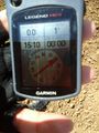
67 KM by bull, tron by the way
Photos
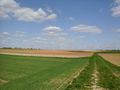
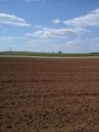
the first view to the hash. It's on the ploughed field behind the green one.
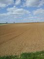
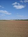
there, 30m in this direction
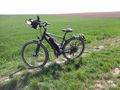
I left my bull alone
proof
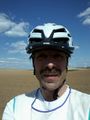
I should improve my grinning. But so it looks stupid at least
to the east
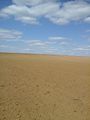
north
west
and bull
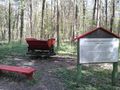
Another peace of history. During WW II there was a railway through Sellheim to transport munition to the french border


Achievements
DODO earned the Land geohash achievement
|
DODO earned the Tron achievement
|