Difference between revisions of "2015-05-25 45 -122"
imported>Shmur (→Participants) |
m |
||
| (8 intermediate revisions by 2 users not shown) | |||
| Line 27: | Line 27: | ||
== Plans == | == Plans == | ||
<!-- what were the original plans --> | <!-- what were the original plans --> | ||
| + | The original plan was to drive as far as possible, then park my car on the side of the road and hike the remaining distance to the point. | ||
== Expedition == | == Expedition == | ||
<!-- how it all turned out. your narrative goes here. --> | <!-- how it all turned out. your narrative goes here. --> | ||
| + | I left home around 1430, hopping on 26 east to I5 north, and crossed into Washington. Got off I5 at exit 11 near Battleground, and then took a series of progressively smaller and more rural roads, for about 45 minutes. The drive was actually quite beautiful, past tree farms, cow and other livestock farms, and through some old growth temperate rain forest. Eventually I ended up on a gravel road, and came to a posted No Trespassing sign, with only about a mile to go until I could park and hike. I decided to turn around at this point. | ||
| − | == | + | == Photos == |
| − | |||
| − | |||
| − | |||
| − | |||
| − | |||
<gallery perrow="5"> | <gallery perrow="5"> | ||
| + | Image:IMG 2691.jpg | Turned around when I saw this. | ||
</gallery> | </gallery> | ||
== Achievements == | == Achievements == | ||
| − | {{ | + | {{No trespassing |
| − | + | | latitude = 45 | |
| − | + | | longitude =-122 | |
| − | + | | date = 2015-05-24 | |
| − | + | | name = Shmur | |
| − | + | }} | |
| − | |||
| − | |||
| − | |||
| − | |||
| − | |||
| − | |||
| − | |||
| − | |||
| − | |||
[[Category:Expeditions]] | [[Category:Expeditions]] | ||
| − | |||
| − | |||
| − | |||
| − | |||
| − | |||
| − | |||
| − | |||
| − | |||
| − | |||
| − | |||
| − | |||
[[Category:Coordinates not reached]] | [[Category:Coordinates not reached]] | ||
| − | |||
| − | |||
| − | |||
| − | |||
| − | |||
[[Category:Not reached - No public access]] | [[Category:Not reached - No public access]] | ||
| − | + | {{location|US|WA|CR}} | |
| − | |||
| − | |||
| − | |||
| − | |||
| − | |||
| − | |||
| − | |||
Latest revision as of 10:06, 12 September 2021
| Mon 25 May 2015 in 45,-122: 45.9588443, -122.5133527 geohashing.info google osm bing/os kml crox |
Location
South slope of Green Mountain in Clark County, Washington approximately 500 feet from the nearest road (Headland Road)
Participants
Plans
The original plan was to drive as far as possible, then park my car on the side of the road and hike the remaining distance to the point.
Expedition
I left home around 1430, hopping on 26 east to I5 north, and crossed into Washington. Got off I5 at exit 11 near Battleground, and then took a series of progressively smaller and more rural roads, for about 45 minutes. The drive was actually quite beautiful, past tree farms, cow and other livestock farms, and through some old growth temperate rain forest. Eventually I ended up on a gravel road, and came to a posted No Trespassing sign, with only about a mile to go until I could park and hike. I decided to turn around at this point.
Photos
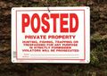
Turned around when I saw this.

Achievements
Shmur earned the No trespassing consolation prize
|