Difference between revisions of "2015-06-09 51 9"
From Geohashing
imported>GeorgDerReisende (create page) |
imported>FippeBot m (Location) |
||
| (One intermediate revision by one other user not shown) | |||
| Line 1: | Line 1: | ||
| − | |||
| − | |||
| − | |||
| − | |||
| − | |||
| − | |||
| − | |||
| − | |||
| − | |||
| − | |||
{{meetup graticule | {{meetup graticule | ||
| lat=51 | | lat=51 | ||
| Line 18: | Line 8: | ||
__NOTOC__ | __NOTOC__ | ||
== Location == | == Location == | ||
| − | + | ||
| + | The hash lay in the industrial park of Breuna. | ||
== Participants == | == Participants == | ||
| − | + | ||
| − | + | [[User:GeorgDerReisende|GeorgDerReisende]] | |
== Plans == | == Plans == | ||
| − | + | ||
| + | The hash was too near to not to go. Hitchhiking. | ||
== Expedition == | == Expedition == | ||
| − | |||
| − | + | I left home at 4 p.m., started to hitchhike at 5 p.m., got a lift with the second car, arrived at Breuna at 17:20. 820 meters distance. I walked along the only street in this area, looking at green meadows. Came near to the hash and found it. Walked back to the main street, started to hitchhike at 17:55, and after twenty minutes I got a car back to Kassel. | |
| − | |||
== Photos == | == Photos == | ||
| − | |||
| − | |||
| − | |||
<gallery perrow="5"> | <gallery perrow="5"> | ||
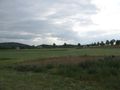
| + | 2015-06-09 51 9 GeorgDerReisende 8337.jpg | on the way to Breuna | ||
| + | 2015-06-09 51 9 GeorgDerReisende 8341.jpg | arrived near the hash | ||
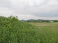
| + | 2015-06-09 51 9 GeorgDerReisende 8349.jpg | 50 meters to hash | ||
| + | 2015-06-09 51 9 GeorgDerReisende 8350.jpg | 40 meters to hash | ||
| + | 2015-06-09 51 9 GeorgDerReisende 8355.jpg | 10 meters to hash | ||
| + | 2015-06-09 51 9 GeorgDerReisende 8357.jpg | 0 meters to hash | ||
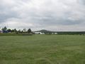
| + | 2015-06-09 51 9 GeorgDerReisende 8359.jpg | east | ||
| + | 2015-06-09 51 9 GeorgDerReisende 8360.jpg | north | ||
| + | 2015-06-09 51 9 GeorgDerReisende 8361.jpg | west | ||
| + | 2015-06-09 51 9 GeorgDerReisende 8362.jpg | south | ||
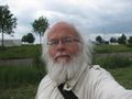
| + | 2015-06-09 51 9 GeorgDerReisende 8363.jpg | the geohasher | ||
| + | 2015-06-09 51 9 GeorgDerReisende 8367.jpg | the hash in the distance | ||
| + | 2015-06-09 51 9 GeorgDerReisende 8372.jpg | going home | ||
</gallery> | </gallery> | ||
| Line 44: | Line 44: | ||
<!-- Add any achievement ribbons you earned below, or remove this section --> | <!-- Add any achievement ribbons you earned below, or remove this section --> | ||
| + | {{Thumbs Up | latitude = 51 | longitude = 9 | date = 2015-06-09 | name = GeorgDerReisende }} | ||
| − | + | [[Category:Expeditions]] | |
| − | |||
| − | [[Category: | ||
| − | + | [[Category:Expeditions with photos]] | |
| − | |||
| − | |||
| − | |||
| − | [[Category: | ||
| − | |||
| − | |||
| − | |||
| − | |||
| − | |||
| − | |||
| − | |||
| − | |||
| − | |||
| − | |||
[[Category:Coordinates reached]] | [[Category:Coordinates reached]] | ||
| − | + | {{location|DE|HE|KS}} | |
| − | |||
| − | |||
| − | |||
| − | |||
| − | |||
| − | |||
| − | |||
| − | |||
| − | |||
| − | |||
| − | |||
| − | |||
| − | |||
| − | |||
| − | |||
| − | |||
| − | |||
Latest revision as of 03:58, 15 August 2019
| Tue 9 Jun 2015 in 51,9: 51.4018270, 9.1962147 geohashing.info google osm bing/os kml crox |
Location
The hash lay in the industrial park of Breuna.
Participants
Plans
The hash was too near to not to go. Hitchhiking.
Expedition
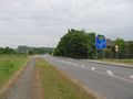
I left home at 4 p.m., started to hitchhike at 5 p.m., got a lift with the second car, arrived at Breuna at 17:20. 820 meters distance. I walked along the only street in this area, looking at green meadows. Came near to the hash and found it. Walked back to the main street, started to hitchhike at 17:55, and after twenty minutes I got a car back to Kassel.
Photos
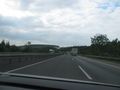
on the way to Breuna
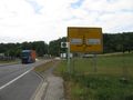
arrived near the hash
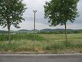
50 meters to hash
40 meters to hash
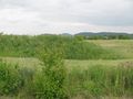
10 meters to hash
0 meters to hash
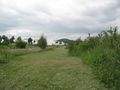
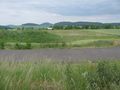
east
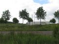
north
west
south
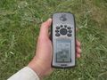
the geohasher
the hash in the distance
going home


Achievements
GeorgDerReisende earned the Thumbs Up Geohash Achievement
|