Difference between revisions of "2015-06-12 47 -117"
imported>Thomcat (Create expedition) |
imported>FippeBot m (Location) |
||
| (5 intermediate revisions by one other user not shown) | |||
| Line 1: | Line 1: | ||
{{meetup graticule | {{meetup graticule | ||
| lat=47 | | lat=47 | ||
| − | | lon=- | + | | lon=-117 |
| date=2015-06-12 | | date=2015-06-12 | ||
| − | | graticule_name= | + | | graticule_name=Spokane |
| − | | graticule_link= | + | | graticule_link=Spokane, Washington |
}} | }} | ||
__NOTOC__ | __NOTOC__ | ||
== Location == | == Location == | ||
| − | + | The Blackwood housing development on a slope just west of the South Hill. | |
== Participants == | == Participants == | ||
| Line 18: | Line 18: | ||
== Expedition == | == Expedition == | ||
| − | + | Hadn't heard of this little development, nestled against the slope of the South Hill. I guess they will build anywhere nowadays. Found it easily enough, drove in... and lost all cell signal. Really? All the cell towers must be on top of the hill or further down the valley. Okay, no more live updates for this one. | |
| + | |||
| + | The overhead map showed the point to be between two streets, likely on property without a house. Thinking this would be a park or greenspace, I pulled up on one of the streets and found green. A tiny strip of green. Turns out there's no house because it is another steep hillside. | ||
| + | |||
| + | Next I cruised around to the other side - could at least scope out which house it was behind. Much luck now - this house is for sale. Was for sale? [http://www.zillow.com/homes/for_sale/Spokane-WA/60823759_zpid/ Zillow] doesn't list an actual sale date. It does reveal that the property goes all the way to the top of the slope, which I didn't know at the time. Must be lovely paying taxes on all of it. | ||
| + | |||
| + | Immediately next to the property is an access path. Perfect. Followed this access path back to the slope, then hash danced my way to the actual point. Success! | ||
== Tracklog == | == Tracklog == | ||
| Line 28: | Line 34: | ||
--> | --> | ||
<gallery perrow="5"> | <gallery perrow="5"> | ||
| + | |||
| + | Image:2015-06-12_47_-117_thomcat_1434146533920.jpg | [http://www.openstreetmap.org/?lat=47.59787049&lon=-117.38956094&zoom=16&layers=B000FTF @47.5979,-117.3896] | ||
| + | |||
| + | Image:2015-06-12_47_-117_TopOfSlope.jpg | Top of the slope | ||
| + | Image:2015-06-12_47_-117_LookingDownslope.jpg | Looking downslope - no easy access here | ||
| + | Image:2015-06-12_47_-117_HouseForSale.jpg | Hashpoint behind this house for sale | ||
| + | Image:2015-06-12_47_-117_AccessBetweenHouses.jpg | Access between the two houses | ||
| + | Image:2015-06-12_47_-117_YoureThere.jpg | Geohashpoint achieved | ||
| + | |||
</gallery> | </gallery> | ||
| Line 35: | Line 50: | ||
| − | |||
| − | |||
| − | |||
[[Category:Expeditions]] | [[Category:Expeditions]] | ||
[[Category:Expeditions with photos]] | [[Category:Expeditions with photos]] | ||
[[Category:Coordinates reached]] | [[Category:Coordinates reached]] | ||
| − | + | {{location|US|WA|SP}} | |
| − | |||
| − | |||
| − | |||
| − | |||
| − | |||
| − | |||
| − | |||
| − | |||
| − | |||
| − | |||
Latest revision as of 04:01, 15 August 2019
| Fri 12 Jun 2015 in Spokane: 47.5997382, -117.3923041 geohashing.info google osm bing/os kml crox |
Location
The Blackwood housing development on a slope just west of the South Hill.
Participants
Plans
Stop by early afternoon, between errands.
Expedition
Hadn't heard of this little development, nestled against the slope of the South Hill. I guess they will build anywhere nowadays. Found it easily enough, drove in... and lost all cell signal. Really? All the cell towers must be on top of the hill or further down the valley. Okay, no more live updates for this one.
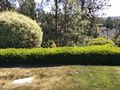
The overhead map showed the point to be between two streets, likely on property without a house. Thinking this would be a park or greenspace, I pulled up on one of the streets and found green. A tiny strip of green. Turns out there's no house because it is another steep hillside.
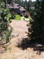
Next I cruised around to the other side - could at least scope out which house it was behind. Much luck now - this house is for sale. Was for sale? Zillow doesn't list an actual sale date. It does reveal that the property goes all the way to the top of the slope, which I didn't know at the time. Must be lovely paying taxes on all of it.
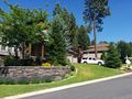
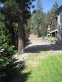
Immediately next to the property is an access path. Perfect. Followed this access path back to the slope, then hash danced my way to the actual point. Success!
Tracklog
Photos
Top of the slope
Looking downslope - no easy access here
Hashpoint behind this house for sale
Access between the two houses

Geohashpoint achieved


