Difference between revisions of "2015-07-15 49 8"
From Geohashing
imported>Tads |
imported>FippeBot m (Location) |
||
| (One intermediate revision by one other user not shown) | |||
| Line 48: | Line 48: | ||
{{#vardefine:ribbonwidth|800px}} | {{#vardefine:ribbonwidth|800px}} | ||
<!-- Add any achievement ribbons you earned below, or remove this section --> | <!-- Add any achievement ribbons you earned below, or remove this section --> | ||
| − | |||
| − | |||
| − | |||
| − | |||
| − | |||
[[Category:Expeditions]] | [[Category:Expeditions]] | ||
[[Category:Expeditions with photos]] | [[Category:Expeditions with photos]] | ||
[[Category:Coordinates reached]] | [[Category:Coordinates reached]] | ||
| + | {{location|DE|HE|DA}} | ||
Latest revision as of 04:22, 15 August 2019
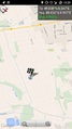
| Wed 15 Jul 2015 in 49,8: 49.8377639, 8.5473690 geohashing.info google osm bing/os kml crox |
Location
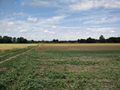
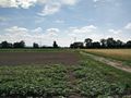
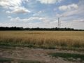
The hashpoint was located on a field close to Griesheim.
Participants
Plans
ToDo
Expedition
ToDo
Photos
GPS Proof
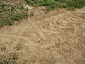
Marker xkcd
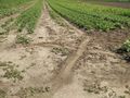
Marker x
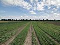
View to the east
View to the north
View to the south
View to the west


