Difference between revisions of "2015-07-21 49 8"
From Geohashing
imported>Sourcerer m (→removed new report category) |
m (→Achievements) |
||
| (2 intermediate revisions by 2 users not shown) | |||
| Line 23: | Line 23: | ||
== Photos == | == Photos == | ||
| − | |||
| − | |||
| − | |||
<gallery perrow="5"> | <gallery perrow="5"> | ||
| + | Image:tads_2015-07-21_49_8_blockedpath.jpg | This path was muddy and "blocked" due to sprinkler irrigation. | ||
| + | Image:tads_2015-07-21_49_8_field.jpg | Field | ||
| + | Image:tads_2015-07-21_49_8_pano.png | Panoramic view across the field from the hashpoint | ||
| + | Image:tads_2015-07-21_49_8_proof.png | GPS proof | ||
</gallery> | </gallery> | ||
| − | |||
== Achievements == | == Achievements == | ||
| Line 34: | Line 34: | ||
{{bicycle geohash | {{bicycle geohash | ||
| − | | latitude = | + | | latitude = 49 |
| − | | longitude = | + | | longitude = 8 |
| date = 2015-07-21 | | date = 2015-07-21 | ||
| name = Cuxi and tads | | name = Cuxi and tads | ||
| Line 51: | Line 51: | ||
[[Category:Expeditions with photos]] | [[Category:Expeditions with photos]] | ||
--> | --> | ||
| + | {{location|DE|HE|GG}} | ||
Latest revision as of 16:32, 26 March 2020
| Tue 21 Jul 2015 in 49,8: 49.7605390, 8.5481940 geohashing.info google osm bing/os kml crox |
Location
On a field between Gernsheim and Bickenbach, close to the A67.
Participants
Cuxi and tads
Plans
An air-line distance of only 15km from Darmstadt is enough incentive to do a bike tour on a nice summer day to visit the hashpoint.
Expedition
ToDo
Photos
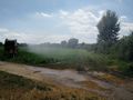
This path was muddy and "blocked" due to sprinkler irrigation.
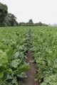
Field
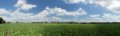
Panoramic view across the field from the hashpoint
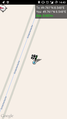
GPS proof


Achievements
Cuxi and tads earned the Bicycle geohash achievement
|