Difference between revisions of "2015-07-23 47 -117"
imported>Thomcat (Created page with "{{meetup graticule | lat=47 | lon=-117 | date=2015-07-23 | graticule_name=Spokane | graticule_link=Spokane, Washington }} __NOTOC__ == Location == In the parking lot of [h...") |
imported>FippeBot m (Location) |
||
| (4 intermediate revisions by one other user not shown) | |||
| Line 12: | Line 12: | ||
== Participants == | == Participants == | ||
| − | * | + | * Michael, doing a favor for [[User:Thomcat|Thomcat]] |
== Plans == | == Plans == | ||
| − | Stop by after work. | + | Stop by after work, approximately 4:30 (the puppet is in motion...) |
== Expedition == | == Expedition == | ||
<!-- how it all turned out. your narrative goes here. --> | <!-- how it all turned out. your narrative goes here. --> | ||
| + | Seeing the spot, and right before leaving for my own [[2015-07-23 47 -122|geohash]] of the day, I contacted my friend Michael via email with two graphics extracted from the web. He agreed - achievement sighted! | ||
| + | |||
| + | He left work shortly before I did, confirming he would swing by the spot. I updated the page for the last time and headed out myself. | ||
| + | |||
| + | On the road, I received the first two images - neither with a GPS. Quickly I texted him to take a wider picture or send me his GPS coordinates. Without knowledge of where he was supposed to be, little fudging was likely. | ||
| + | |||
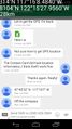
| + | Coincidentally, this conversation would give me a chance to prove my location, more than 300 km away. Unfortunately, the image overlay was close to useless (the font too large or placement wrong), but the OSM coords were proof enough. | ||
| + | |||
| + | The IM with contact info arrived, and it looked close to me. I saved a screen shot while he sent me the reading from phone GPS - another set of coordinates. These also looked close, so I thanked him for his time and signed off for the rest of the drive home. | ||
== Tracklog == | == Tracklog == | ||
| Line 28: | Line 37: | ||
--> | --> | ||
<gallery perrow="5"> | <gallery perrow="5"> | ||
| + | |||
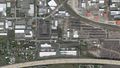
| + | Image:2015-07-23_47_-117_SiteOverview.jpg | ||
| + | Image:2015-07-23_47_-117_SiteMap.jpg | ||
| + | |||
| + | Image:2015-07-23 47 -117 Location.jpg | The correct parking spot | ||
| + | Image:2015-07-23 47 -117 Puppet.jpg | More than a minion | ||
| + | Image:2015-07-23_47_-117_thomcat_1437695897189.jpg | Thomcat is at [http://www.openstreetmap.org/?lat=47.75855845&lon=-122.25776555&zoom=16&layers=B000FTF @47.7586,-122.2578] | ||
| + | Image:2015-07-23 47 -117 ContactCard.jpg | The proof | ||
</gallery> | </gallery> | ||
| Line 33: | Line 50: | ||
{{#vardefine:ribbonwidth|800px}} | {{#vardefine:ribbonwidth|800px}} | ||
<!-- Add any achievement ribbons you earned below, or remove this section --> | <!-- Add any achievement ribbons you earned below, or remove this section --> | ||
| + | {{Puppet Master Geohash | ||
| + | | latitude = 47 | ||
| + | | longitude = -117 | ||
| + | | date = 2015-07-23 | ||
| + | | puppet = Michael | ||
| + | | name = [[User:Thomcat|Thomcat]] | ||
| + | | image = 2015-07-23 47 -117 Puppet.jpg | ||
| + | }} | ||
| − | |||
| − | |||
| − | |||
| − | |||
[[Category:Expeditions]] | [[Category:Expeditions]] | ||
[[Category:Expeditions with photos]] | [[Category:Expeditions with photos]] | ||
[[Category:Coordinates reached]] | [[Category:Coordinates reached]] | ||
| − | + | {{location|US|WA|SP}} | |
| − | |||
| − | |||
| − | |||
| − | |||
| − | |||
| − | |||
| − | |||
| − | |||
| − | |||
| − | |||
Latest revision as of 04:27, 15 August 2019
| Thu 23 Jul 2015 in Spokane: 47.6756476, -117.2690233 geohashing.info google osm bing/os kml crox |
Location
In the parking lot of Carrington College in Spokane Valley.
Participants
- Michael, doing a favor for Thomcat
Plans
Stop by after work, approximately 4:30 (the puppet is in motion...)
Expedition
Seeing the spot, and right before leaving for my own geohash of the day, I contacted my friend Michael via email with two graphics extracted from the web. He agreed - achievement sighted!
He left work shortly before I did, confirming he would swing by the spot. I updated the page for the last time and headed out myself.
On the road, I received the first two images - neither with a GPS. Quickly I texted him to take a wider picture or send me his GPS coordinates. Without knowledge of where he was supposed to be, little fudging was likely.
Coincidentally, this conversation would give me a chance to prove my location, more than 300 km away. Unfortunately, the image overlay was close to useless (the font too large or placement wrong), but the OSM coords were proof enough.
The IM with contact info arrived, and it looked close to me. I saved a screen shot while he sent me the reading from phone GPS - another set of coordinates. These also looked close, so I thanked him for his time and signed off for the rest of the drive home.
Tracklog
Photos

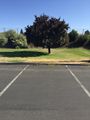
The correct parking spot

More than a minion
Thomcat is at @47.7586,-122.2578

The proof


Achievements
Thomcat earned the Puppet Master Geohash achievement
|