Difference between revisions of "2015-07-25 41 -73"
imported>OtherJack ([live] Setting out from Harlem on the metro north...) |
imported>FippeBot m (Location) |
||
| (7 intermediate revisions by one other user not shown) | |||
| Line 20: | Line 20: | ||
== Location == | == Location == | ||
<!-- where you've surveyed the hash to be --> | <!-- where you've surveyed the hash to be --> | ||
| + | |||
| + | Overgrown attempt at development, east of Peekskill | ||
== Participants == | == Participants == | ||
<!-- who attended: If you link to your wiki user name in this section, your expedition will be picked up by the various statistics generated for geohashing. You may use three tildes ~ as a shortcut to automatically insert the user signature of the account you are editing with. | <!-- who attended: If you link to your wiki user name in this section, your expedition will be picked up by the various statistics generated for geohashing. You may use three tildes ~ as a shortcut to automatically insert the user signature of the account you are editing with. | ||
--> | --> | ||
| + | |||
| + | [[User:OtherJack|OtherJack]] | ||
== Plans == | == Plans == | ||
<!-- what were the original plans --> | <!-- what were the original plans --> | ||
| + | My plans were to take Metro-North to Peekskill station and walk an hour from there, since it was such a beautiful sunny day. | ||
== Expedition == | == Expedition == | ||
| Line 33: | Line 38: | ||
*Setting out from Harlem on the metro north... -- [[User:OtherJack|OtherJack]] ([[User talk:OtherJack|talk]]) [http://www.openstreetmap.org/?lat=40.80510080&lon=-73.93922660&zoom=16&layers=B000FTF @40.8051,-73.9392] 12:42, 25 July 2015 (EDT) | *Setting out from Harlem on the metro north... -- [[User:OtherJack|OtherJack]] ([[User talk:OtherJack|talk]]) [http://www.openstreetmap.org/?lat=40.80510080&lon=-73.93922660&zoom=16&layers=B000FTF @40.8051,-73.9392] 12:42, 25 July 2015 (EDT) | ||
| − | + | ||
| − | + | I made it without much trouble (but with a couple minor raptor scratches) a bit after 3pm. More details and photos coming. Am also going for tomorrow's in New Jersey with a drag-along or two. -- [[User:OtherJack|OtherJack]] ([[User talk:OtherJack|talk]]) 01:35, 26 July 2015 (EDT) | |
== Photos == | == Photos == | ||
| Line 41: | Line 46: | ||
--> | --> | ||
<gallery perrow="5"> | <gallery perrow="5"> | ||
| + | Image:2015-07-25 13.56.31.jpg | I got off the train at Peekskill, where the Hudson emerges from its Highlands. | ||
| + | Image:2015-07-25 13.57.51.jpg | Looking the other way there was this mansion on a hill. | ||
| + | Image:2015-07-25 14.07.23.jpg | Then I began my hike to the hash, passing Oley and Chuck's Rainbow. | ||
| + | Image:2015-07-25 14.08.49.jpg | It was a long gentle climb up to downtown Peekskill. I thought this guy might have been a fellow hasher, but he wasn't. | ||
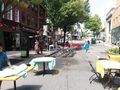
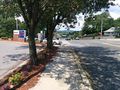
| + | Image:2015-07-25 14.14.35.jpg | In downtown Peekskill they were getting ready for a Jazz & Blues Festival! | ||
| + | Image:2015-07-25 14.15.16.jpg | ||
| + | Image:2015-07-25 14.18.40.jpg | Peekskill had some beautiful old big wooden houses, ... | ||
| + | Image:2015-07-25 14.28.35.jpg | ... a contemporary art museum, and at least one cheap liquor store. | ||
| + | Image:2015-07-25 14.36.34.jpg | Further out it looked more suburban. | ||
| + | Image:2015-07-25 14.40.11.jpg | There were no beaches (or popes) anywhere nearby here, despite their evident wishes. | ||
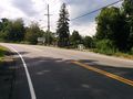
| + | Image:2015-07-25 14.57.16.jpg | At last I crested the hill and approached the road to the hash, with a view of the Taconics as my reward. | ||
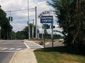
| + | Image:2015-07-25 15.04.57.jpg | After a bit of winding, the hash-development came into view. | ||
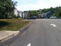
| + | Image:2015-07-25 15.05.36.jpg | It was called Hillside Estates. | ||
| + | Image:2015-07-25 15.09.10.jpg | Happily, they'd never got around to developing the hashlot. | ||
| + | Image:2015-07-25 15.09.15.jpg | ||
| + | Image:2015-07-25 15.18.42.jpg | I picked my way through the tall grass until I was at the hashpoint! | ||
| + | Image:2015-07-25 15.19.55.jpg | Tall grass is also raptor habitat, as you can see. | ||
| + | Image:2015-07-25 15.20.08.jpg | ||
| + | Image:2015-07-25 15.20.18.jpg | ||
| + | Image:2015-07-25 15.20.32.jpg | ||
| + | Image:2015-07-25 15.24.44.jpg | I lingered for a while in this beautiful spot, but eventually headed back. | ||
| + | Image:2015-07-25 15.49.38.jpg | Peekskill even had a Hebrew Congregation... with Bingo. | ||
| + | Image:2015-07-25 15.54.39.jpg | View of the Hudson Highlands from the hash-ridge, headed downhill now. | ||
| + | Image:2015-07-25 16.00.30.jpg | All your Fence Need (are belong to us!) | ||
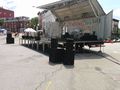
| + | Image:2015-07-25 16.01.43.jpg | Coolest Meineke Brakes & Mufflers truck in America | ||
| + | Image:2015-07-25 16.03.37.jpg | ||
| + | Image:2015-07-25 16.16.22.jpg | Back at the Jazz & Blues Festival it was just local teenagers doing pop covers and dance routines. Ah well. | ||
| + | Image:2015-07-25 16.16.57.jpg | But there was also a piano store with a cool sign. | ||
| + | Image:2015-07-25 16.25.23.jpg | N. DAIN'S SON'S CO. INC. (not far from Oley and Chuck's Rainbow) | ||
| + | Image:2015-07-25 16.32.03.jpg | And at last I was back at the Hudson! With a couple minutes to spare for photos, even... | ||
| + | Image:2015-07-25 16.33.20.jpg | ||
| + | Image:2015-07-25 16.33.25.jpg | ||
| + | Image:2015-07-25 16.33.34.jpg | ||
| + | Image:2015-07-25 16.34.51.jpg | ...before catching the Metro-North back to the city. | ||
| + | |||
</gallery> | </gallery> | ||
| Line 47: | Line 87: | ||
<!-- Add any achievement ribbons you earned below, or remove this section --> | <!-- Add any achievement ribbons you earned below, or remove this section --> | ||
| − | + | {{Velociraptor geohash | |
| − | |||
| − | |||
| − | + | | latitude = 41 | |
| − | + | | longitude = -73 | |
| − | [[ | + | | date = 2015-07-25 |
| − | + | | name = [[User:OtherJack|OtherJack]] | |
| + | |||
| + | }} | ||
| + | |||
| + | {{Public transport geohash | ||
| + | |||
| + | | latitude = 41 | ||
| + | | longitude = -73 | ||
| + | | date = 2015-07-25 | ||
| + | | busline = Metro-North Railroad | ||
| + | | name = [[User:OtherJack|OtherJack]] | ||
| − | + | }} | |
| − | |||
[[Category:Expeditions]] | [[Category:Expeditions]] | ||
| − | |||
[[Category:Expeditions with photos]] | [[Category:Expeditions with photos]] | ||
| − | |||
| − | |||
| − | |||
| − | |||
| − | |||
[[Category:Coordinates reached]] | [[Category:Coordinates reached]] | ||
| − | + | {{location|US|NY|WE}} | |
| − | |||
| − | |||
| − | |||
| − | |||
| − | |||
| − | |||
| − | |||
| − | |||
| − | |||
| − | |||
| − | |||
| − | |||
| − | |||
| − | |||
| − | |||
| − | |||
| − | |||
Latest revision as of 04:29, 15 August 2019
| Sat 25 Jul 2015 in 41,-73: 41.3067980, -73.8888245 geohashing.info google osm bing/os kml crox |
Location
Overgrown attempt at development, east of Peekskill
Participants
Plans
My plans were to take Metro-North to Peekskill station and walk an hour from there, since it was such a beautiful sunny day.
Expedition
- Setting out from Harlem on the metro north... -- OtherJack (talk) @40.8051,-73.9392 12:42, 25 July 2015 (EDT)
I made it without much trouble (but with a couple minor raptor scratches) a bit after 3pm. More details and photos coming. Am also going for tomorrow's in New Jersey with a drag-along or two. -- OtherJack (talk) 01:35, 26 July 2015 (EDT)
Photos
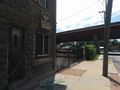
I got off the train at Peekskill, where the Hudson emerges from its Highlands.
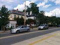
Looking the other way there was this mansion on a hill.
Then I began my hike to the hash, passing Oley and Chuck's Rainbow.
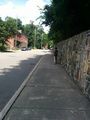
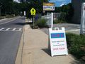
It was a long gentle climb up to downtown Peekskill. I thought this guy might have been a fellow hasher, but he wasn't.
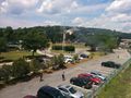
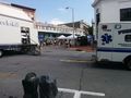
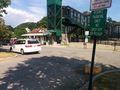
In downtown Peekskill they were getting ready for a Jazz & Blues Festival!
Peekskill had some beautiful old big wooden houses, ...
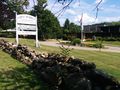
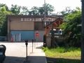
... a contemporary art museum, and at least one cheap liquor store.
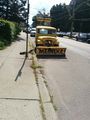
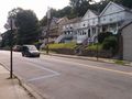
Further out it looked more suburban.
There were no beaches (or popes) anywhere nearby here, despite their evident wishes.
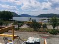
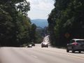
At last I crested the hill and approached the road to the hash, with a view of the Taconics as my reward.
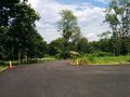
After a bit of winding, the hash-development came into view.
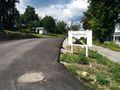
It was called Hillside Estates.
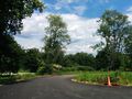
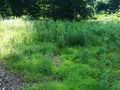
Happily, they'd never got around to developing the hashlot.
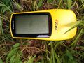
I picked my way through the tall grass until I was at the hashpoint!
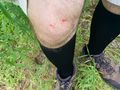
Tall grass is also raptor habitat, as you can see.
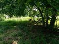

I lingered for a while in this beautiful spot, but eventually headed back.
Peekskill even had a Hebrew Congregation... with Bingo.
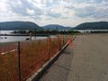
View of the Hudson Highlands from the hash-ridge, headed downhill now.
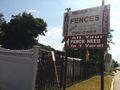
All your Fence Need (are belong to us!)
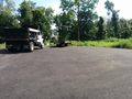
Coolest Meineke Brakes & Mufflers truck in America
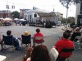
Back at the Jazz & Blues Festival it was just local teenagers doing pop covers and dance routines. Ah well.
But there was also a piano store with a cool sign.
N. DAIN'S SON'S CO. INC. (not far from Oley and Chuck's Rainbow)
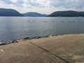
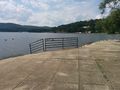
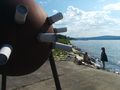
And at last I was back at the Hudson! With a couple minutes to spare for photos, even...
...before catching the Metro-North back to the city.


Achievements
OtherJack earned the Velociraptor Geohash Achievement
|
OtherJack earned the Public transport geohash achievement
|