Difference between revisions of "2015-08-03 51 13"
imported>Danatar (Planning) |
imported>FippeBot m (Location) |
||
| (2 intermediate revisions by one other user not shown) | |||
| Line 8: | Line 8: | ||
== Location == | == Location == | ||
| − | Today's location is at the edge of the ''Prager Carree'', right next to Dresden's main shopping mile, the ''Prager Straße'' (Prague street). On the other side of the ''Prager Carree'' are the ''Wiener Platz'' ("Vienna Square") and the [[wikipedia:Dresden Hauptbahnhof|Dresden Hauptbahnhof]] main train station. ''Prager Carree'' ("Prague Block") is the name of a 6-house 241-appartment complex that is being constructed in the past year, just 2-3 weeks ago the topping-out took place. Before, the construction pit (called ''Wiener Loch/"Vienna hole"'' by the locals) lay idle for many years because of incompetence in developing the site, costing the city many many millions of Euros. | + | Today's location is at the edge of the ''Prager Carree'', right next to Dresden's main shopping mile, the ''Prager Straße'' (Prague street). On the other side of the ''Prager Carree'' are the ''Wiener Platz'' ("Vienna Square") and the [[wikipedia:Dresden Hauptbahnhof|Dresden Hauptbahnhof]] main train station. ''Prager Carree'' ("Prague Block") is the name of a 6-house 241-appartment complex that is being constructed in the past year, just 2-3 weeks ago the topping-out took place. Before, the construction pit (called ''Wiener Loch/"Vienna hole"'' by the locals) lay idle for many years because of incompetence in developing the site, costing the city many many millions of Euros. Because of strange GPS reception, the hashpoint is not one spot but instead, according to my GPS unit, a 3000 square meter (about 32000 square feet) area. |
Country: Germany; state: Sachsen (Saxony, EU:DE:SN); district: Dresden; Ortsamt: Altstadt; statistischer Stadtteil: Seevorstadt-Ost/Großer Garten | Country: Germany; state: Sachsen (Saxony, EU:DE:SN); district: Dresden; Ortsamt: Altstadt; statistischer Stadtteil: Seevorstadt-Ost/Großer Garten | ||
| − | Weather: | + | Weather: sunny, very hot. Around 30 °C in the shade at the time I was there, but there was no shade. |
| − | |||
==[[User:Danatar|Danatar]]== | ==[[User:Danatar|Danatar]]== | ||
| Line 19: | Line 18: | ||
I plan to walk there in the morning, I don't have a time planned yet. I scouted the the location today (Saturday) while shopping, it's inside the construction site's fence. I will not be able to reach the spot from the satellite image, but perhaps the GPS inaccuracy between the buildings will bring the exact coordinates to me. It's just too close to not try. | I plan to walk there in the morning, I don't have a time planned yet. I scouted the the location today (Saturday) while shopping, it's inside the construction site's fence. I will not be able to reach the spot from the satellite image, but perhaps the GPS inaccuracy between the buildings will bring the exact coordinates to me. It's just too close to not try. | ||
| − | + | ||
=== Expedition=== | === Expedition=== | ||
| + | I started at noon and walked through the ''Großer Garten'' and past the ''Hygienemuseum''. There was a skate park along the way but it was abandoned at this time of day. After crossing the tram line I walked parallel to ''Prager Straße'' for a while and crossed over to it only a short way from the hashpoint. As always, there were lots of people shopping. At 12:45 reached the place that I had scouted on Saturday, the GPS unit was still searching for satellites after I had walked under a large building. When the satellites came back I walked first to one corner of the construction site, then to the next one, but the GPS told me I was still 30 meters ''south'' of the spot. | ||
| + | |||
| + | I started my GPS dance, although this time it was the GPS that danced while I was mostly standing still. From being 30 meters too far to the south the GPS went to 50 meters too far to the north, all this while I was on the 4 meter wide east-west running street between the construction site and a shop and with a GPS accuracy of 5-8 meters! I only went some steps to and fro to keep the LON coordinates mostly right, while waiting for the correct LAT coordinates, those alternated between some meters to the south of me and some meters to the north for a while. After about 25 minutes I was able to take a picture of the perfect coordinates, which wasn't easy because the GPS display and the direct sunlight didn't mix. All the time, the construction workers were lifting huge sheets to the top of one of the houses with a crane, paying me no heed. Some people were passing me by with only a short glance. Having been successfully reached by the hashpoint I walked along ''Prager Straße'', spent half an hour trying new hiking boots (the old ones are losing their soles and repairing them would cost 99 € / US$108) in the outdoor store and walked towards home. I took another route because I was later than planned, but I made it home in time to have a quick late lunch and go to work on time. | ||
{{gallery|width=200|height=200|lines=2 | {{gallery|width=200|height=200|lines=2 | ||
| − | |Image:2015-08- | + | |Image:2015-08-03_51_13_near.jpg|almost there |
| + | |Image:2015-08-03_51_13_gps.jpg|GPS | ||
| + | |Image:2015-08-03_51_13_spot.jpg|the hasharea | ||
| + | |Image:2015-08-03_51_13_hp.jpg|geohasher reached by coordinates | ||
| + | |Image:2015-08-03_51_13_pragercarree.jpg|''Prager Carree'' construction site | ||
| + | |Image:2015-08-03_51_13_eckeNO.jpg|view for future "revisited" pictures | ||
| + | |Image:2015-08-03_51_13_klavierpferd.jpg|this guy had been there on Saturday, too | ||
}} | }} | ||
| Line 31: | Line 39: | ||
===tracklog=== | ===tracklog=== | ||
| − | + | [http://www.everytrail.com/view_trip.php?trip_id=3198380&code=ee37773074d87e14f1e0814bd8db3a3f Triton tracklog] | |
[[Category:Expeditions]] | [[Category:Expeditions]] | ||
[[Category:Expeditions with photos]] | [[Category:Expeditions with photos]] | ||
| − | [[Category:Coordinates reached | + | [[Category:Coordinates reached]] |
[[Category:Danatar]] | [[Category:Danatar]] | ||
| + | {{location|DE|SN|DD}} | ||
Latest revision as of 04:39, 15 August 2019
| Mon 3 Aug 2015 in Dresden: 51.0421194, 13.7341844 geohashing.info google osm bing/os kml crox |
Location
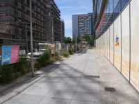
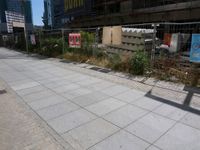
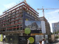
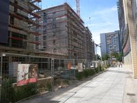
Today's location is at the edge of the Prager Carree, right next to Dresden's main shopping mile, the Prager Straße (Prague street). On the other side of the Prager Carree are the Wiener Platz ("Vienna Square") and the Dresden Hauptbahnhof main train station. Prager Carree ("Prague Block") is the name of a 6-house 241-appartment complex that is being constructed in the past year, just 2-3 weeks ago the topping-out took place. Before, the construction pit (called Wiener Loch/"Vienna hole" by the locals) lay idle for many years because of incompetence in developing the site, costing the city many many millions of Euros. Because of strange GPS reception, the hashpoint is not one spot but instead, according to my GPS unit, a 3000 square meter (about 32000 square feet) area.
Country: Germany; state: Sachsen (Saxony, EU:DE:SN); district: Dresden; Ortsamt: Altstadt; statistischer Stadtteil: Seevorstadt-Ost/Großer Garten
Weather: sunny, very hot. Around 30 °C in the shade at the time I was there, but there was no shade.
Danatar
Planning
I plan to walk there in the morning, I don't have a time planned yet. I scouted the the location today (Saturday) while shopping, it's inside the construction site's fence. I will not be able to reach the spot from the satellite image, but perhaps the GPS inaccuracy between the buildings will bring the exact coordinates to me. It's just too close to not try.
Expedition
I started at noon and walked through the Großer Garten and past the Hygienemuseum. There was a skate park along the way but it was abandoned at this time of day. After crossing the tram line I walked parallel to Prager Straße for a while and crossed over to it only a short way from the hashpoint. As always, there were lots of people shopping. At 12:45 reached the place that I had scouted on Saturday, the GPS unit was still searching for satellites after I had walked under a large building. When the satellites came back I walked first to one corner of the construction site, then to the next one, but the GPS told me I was still 30 meters south of the spot.
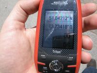
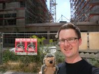
I started my GPS dance, although this time it was the GPS that danced while I was mostly standing still. From being 30 meters too far to the south the GPS went to 50 meters too far to the north, all this while I was on the 4 meter wide east-west running street between the construction site and a shop and with a GPS accuracy of 5-8 meters! I only went some steps to and fro to keep the LON coordinates mostly right, while waiting for the correct LAT coordinates, those alternated between some meters to the south of me and some meters to the north for a while. After about 25 minutes I was able to take a picture of the perfect coordinates, which wasn't easy because the GPS display and the direct sunlight didn't mix. All the time, the construction workers were lifting huge sheets to the top of one of the houses with a crane, paying me no heed. Some people were passing me by with only a short glance. Having been successfully reached by the hashpoint I walked along Prager Straße, spent half an hour trying new hiking boots (the old ones are losing their soles and repairing them would cost 99 € / US$108) in the outdoor store and walked towards home. I took another route because I was later than planned, but I made it home in time to have a quick late lunch and go to work on time.
|
