Difference between revisions of "2015-08-16 49 7"
imported>DODO (→Participants) |
imported>FippeBot m (Location) |
||
| (8 intermediate revisions by one other user not shown) | |||
| Line 29: | Line 29: | ||
== Plans == | == Plans == | ||
<!-- what were the original plans --> | <!-- what were the original plans --> | ||
| + | Have a quick ride on my bull there. | ||
== Expedition == | == Expedition == | ||
<!-- how it all turned out. your narrative goes here. --> | <!-- how it all turned out. your narrative goes here. --> | ||
| + | When I woke up this morning it was raining, and so I waited if it may stop. It did so around 12 o' clock and so I planned to go. When I finished planing and had managed all the preparations it was 1 already and - was raining again. So I started in the rain. I came forward really fast and came through Böhl-Iggelheim, Meckenheim, Niederkirchen and Bad Dürkheim. Here I reached the Palatine forest but I still could move fast as I followed a minored through a valley.Things got harder, when I had to leave the road at the Forsthaus Isenach. From here the way got worse and worse. First it was a gravel road along a ditch,, then it got more and more narrow. It all culminated in a path that was very narrow, very uneven and very steep (upwards of course). It's really hard work to push a 30 kg bull this way up. | ||
| + | |||
| + | Then I crossed the Autobahn and now the way goes downwards on a mellow sandy way where I had to drive really carefully and slow. But after a while things got better again and I could ride a little faster. And the hash couldn't be so far away anymore. I had to turn left on a small path again, where I hardly could ride, especially because it was blocked by fallen trees for several times, where I hat to lift the bull. But finally I came near the hash. I had to cross a small brook and just some meters next to it at the opposite slope it was. | ||
| + | |||
| + | Some pictures later I pushed the bull again and followed the path, although osm sais it would end (I'll correct that later). When I rejoined the planned path I wasn't sure where to go and I missed the way twice before I found out that I had to go upwards again. After awhile I crossed the Autobahn again and the ways are getting better now, although I still had to be carefully as I rode downwards on sandy paths. How happy was I when I reached an asphaltic road again and as I still was going downwards I got really fast now and quickly reached Frankenstein. The place with the scary name is a little village, where you can't find anything to eat (on a sunday afternoon). So I just waited there for the next train, that came in 20 minutes. | ||
| + | |||
| + | I had to switch trains in Schifferstadt, and when I got out of the train, another train just came in. I joined it - and it was the wrong one, that brought me back to Böhl-Iggelheim. I left the train there and had to ride the payback home on my bull again. Just 5 minutes before I reached home, it stopped raining. | ||
== Tracklog == | == Tracklog == | ||
<!-- if your GPS device keeps a log, you may post a link here --> | <!-- if your GPS device keeps a log, you may post a link here --> | ||
| + | [https://www.komoot.de/tour/6343753/zoom 66 KM via hash to Frankenstein] and [https://www.komoot.de/tour/6343773 15KM from Böhl-Iggelheim]. And all the way incl. [http://www.gpsies.com/map.do?fileId=coazpxhikpyyczkx 42 KM train]. | ||
== Photos == | == Photos == | ||
| Line 41: | Line 50: | ||
--> | --> | ||
<gallery perrow="5"> | <gallery perrow="5"> | ||
| + | Image:2015-08-19_49_7-1.jpg|path to push | ||
| + | Image:2015-08-19_49_7-2.jpg|bull near hash | ||
| + | Image:2015-08-19_49_7-3.jpg|first view in the hashes direction | ||
| + | Image:2015-08-19_49_7-4.jpg|ditch to cross | ||
| + | Image:2015-08-19_49_7-5.jpg|first proof | ||
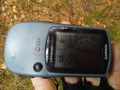
| + | Image:2015-08-19_49_7-14.png|second proof | ||
| + | Image:2015-08-19_49_7-6.jpg|view upwards | ||
| + | Image:2015-08-19_49_7-7.jpg|view downwards | ||
| + | Image:2015-08-19_49_7-8.jpg|view hasherwards | ||
| + | Image:2015-08-19_49_7-9.jpg|view bullwards | ||
| + | Image:2015-08-19_49_7-10.jpg|view to the hash afterwards | ||
| + | Image:2015-08-19_49_7-11.jpg|scary | ||
| + | Image:2015-08-19_49_7-12.jpg|castle Frankenstein | ||
| + | Image:2015-08-19_49_7-13.jpg|from the other side | ||
</gallery> | </gallery> | ||
== Achievements == | == Achievements == | ||
| − | {{ | + | {{land geohash |
| − | + | | latitude = 49 | |
| + | | longitude = 7 | ||
| + | | date = 2015-08-16 | ||
| + | | name = DODO | ||
| + | }} | ||
| − | + | {{consecutive geohash | |
| − | + | | count = 2 | |
| − | + | | latitude = 49 | |
| + | | longitude = 8 | ||
| + | | date = 2015-08-15 | ||
| + | | name = DODO | ||
| + | }} | ||
| − | + | {{OpenStreetMap achievement | |
| − | + | | latitude = 49 | |
| − | + | | longitude = 7 | |
| − | + | | date = 2015-08-16 | |
| + | | OSMlink = 33374421 | ||
| + | | name = DODO | ||
| + | }} | ||
| − | + | {{Drowned rat geohash | |
| + | | latitude = 49 | ||
| + | | longitude = 7 | ||
| + | | date = 2015-08-16 | ||
| + | | name = DODO | ||
| + | | reason = cycling through rain for almost 3 hours | ||
| + | }} | ||
| − | |||
[[Category:Expeditions]] | [[Category:Expeditions]] | ||
| − | |||
| − | |||
| − | |||
| − | |||
| − | |||
| − | |||
| − | |||
[[Category:Coordinates reached]] | [[Category:Coordinates reached]] | ||
| − | + | {{location|DE|RP|ROK}} | |
| − | |||
| − | |||
| − | |||
| − | |||
| − | |||
| − | |||
| − | |||
| − | |||
| − | |||
| − | |||
| − | |||
| − | |||
| − | |||
| − | |||
| − | |||
| − | |||
| − | |||
Latest revision as of 01:15, 7 August 2019
| Sun 16 Aug 2015 in 49,7: 49.4949137, 7.9682920 geohashing.info google osm bing/os kml crox |
Location
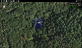
In a narrow valley deep in the Palatine forest near Alsenborn.
Participants
Plans
Have a quick ride on my bull there.
Expedition
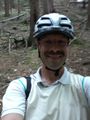
When I woke up this morning it was raining, and so I waited if it may stop. It did so around 12 o' clock and so I planned to go. When I finished planing and had managed all the preparations it was 1 already and - was raining again. So I started in the rain. I came forward really fast and came through Böhl-Iggelheim, Meckenheim, Niederkirchen and Bad Dürkheim. Here I reached the Palatine forest but I still could move fast as I followed a minored through a valley.Things got harder, when I had to leave the road at the Forsthaus Isenach. From here the way got worse and worse. First it was a gravel road along a ditch,, then it got more and more narrow. It all culminated in a path that was very narrow, very uneven and very steep (upwards of course). It's really hard work to push a 30 kg bull this way up.
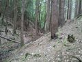
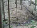
Then I crossed the Autobahn and now the way goes downwards on a mellow sandy way where I had to drive really carefully and slow. But after a while things got better again and I could ride a little faster. And the hash couldn't be so far away anymore. I had to turn left on a small path again, where I hardly could ride, especially because it was blocked by fallen trees for several times, where I hat to lift the bull. But finally I came near the hash. I had to cross a small brook and just some meters next to it at the opposite slope it was.
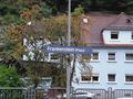
Some pictures later I pushed the bull again and followed the path, although osm sais it would end (I'll correct that later). When I rejoined the planned path I wasn't sure where to go and I missed the way twice before I found out that I had to go upwards again. After awhile I crossed the Autobahn again and the ways are getting better now, although I still had to be carefully as I rode downwards on sandy paths. How happy was I when I reached an asphaltic road again and as I still was going downwards I got really fast now and quickly reached Frankenstein. The place with the scary name is a little village, where you can't find anything to eat (on a sunday afternoon). So I just waited there for the next train, that came in 20 minutes.
I had to switch trains in Schifferstadt, and when I got out of the train, another train just came in. I joined it - and it was the wrong one, that brought me back to Böhl-Iggelheim. I left the train there and had to ride the payback home on my bull again. Just 5 minutes before I reached home, it stopped raining.
Tracklog
66 KM via hash to Frankenstein and 15KM from Böhl-Iggelheim. And all the way incl. 42 KM train.
Photos
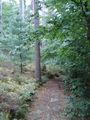
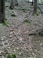
path to push
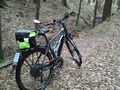
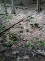
bull near hash
first view in the hashes direction
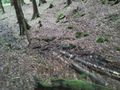
ditch to cross
first proof
second proof
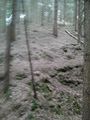
view upwards
view downwards
view hasherwards
view bullwards
view to the hash afterwards
scary
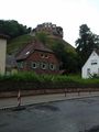
castle Frankenstein
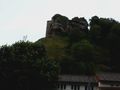
from the other side


Achievements
DODO earned the Land geohash achievement
|
DODO earned the Consecutive geohash achievement
|
DODO earned the OpenStreetMap achievement
|
DODO earned the Drowned Rat Geohash Achievement
|