Difference between revisions of "2015-08-23 51 0"
imported>Huinesoron (Stubbing.) |
imported>FippeBot m (Location) |
||
| (6 intermediate revisions by 3 users not shown) | |||
| Line 1: | Line 1: | ||
| + | [[Image:{{{image|2015-08-23 51 0 StupidCloseup.jpg}}}|thumb|left]] | ||
| − | |||
| − | |||
| − | |||
| − | |||
| − | |||
| − | |||
| − | |||
| − | |||
| − | |||
{{meetup graticule | {{meetup graticule | ||
| lat=51 | | lat=51 | ||
| lon=0 | | lon=0 | ||
| date=2015-08-23 | | date=2015-08-23 | ||
| + | | graticule_name=London East, UK | ||
| + | | graticule_link=London East, United Kingdom | ||
}} | }} | ||
| − | |||
| − | |||
__NOTOC__ | __NOTOC__ | ||
| − | |||
== Location == | == Location == | ||
| − | + | In a field just outside Grays, Essex. | |
== Participants == | == Participants == | ||
| − | + | ||
| − | + | *[[User:Huinesoron|Huinesoron]] ([[User talk:Huinesoron|talk]]) | |
== Plans == | == Plans == | ||
| − | + | Well, how can I ''not'' take a stab at this one? It's less than three miles from my house; that's practically an honorary Couch Potato! | |
== Expedition == | == Expedition == | ||
| − | |||
| − | + | This turned out to be... exactly as easy as I thought it would be. I parked on the kerb opposite the entrance to the field, walked along the edge until I was lined up with the tree from Google Maps, and then paced the 50m across the stubble-filled field until I reached the hash. | |
| − | + | ||
| + | The only real concern I had was that the ominous-looking four-wheel-drive vehicle sitting by the field might contain a mob of angry farmers with shotguns... but it didn't, so that was all right. | ||
== Photos == | == Photos == | ||
| − | |||
| − | |||
| − | |||
<gallery perrow="5"> | <gallery perrow="5"> | ||
| + | Image:2015-08-23 51 0 LooksPleasant.jpg | I think littering is Essex's national industry. | ||
| + | Image:2015-08-23 51 0 OminousCar.jpg | Will the farmer hunt me like a rabid animal? Nah, it's empty. | ||
| + | Image:2015-08-23 51 0 LandmarkTree.jpg | I line up on a tree... | ||
| + | Image:2015-08-23 51 0 HashingFarmer.jpg | ... and follow the geohashing farmer's tracks. | ||
| + | Image:2015-08-23 51 0 HashLookBack.jpg | You thought I was joking about the farmer, didn't you? (Well, I guess I was) | ||
| + | Image:2015-08-23 51 0 StupidCloseup.jpg | I forget how zoom works. | ||
| + | Image:2015-08-23 51 0 DarkSatanicTurbines.jpg | Yeah, what's with all the windmills? | ||
</gallery> | </gallery> | ||
| + | |||
| + | == What's With All The Windmills? == | ||
| + | |||
| + | I've highlighted pictures of windmills in three of my last five reports (the other two being [[2015-08-10 52 -3]] and [[2015-08-22 51 0]]). What's up with that? | ||
| + | |||
| + | Well... this: | ||
== Achievements == | == Achievements == | ||
{{#vardefine:ribbonwidth|800px}} | {{#vardefine:ribbonwidth|800px}} | ||
| − | |||
| − | + | {{gratuitous ribbon | |
| − | + | | color = #00D200 | |
| − | [[ | + | | icon = Quixote.PNG |
| + | | latitude = 51 | ||
| + | | longitude = 0 | ||
| + | | date = 2015-08-23 | ||
| + | | achievement = Tilting At Hashpoints Achievement (Level 1) | ||
| + | | description = encountering windmills/wind turbines at '''3''' hashpoints including the | ||
| + | | name = [[User:Huinesoron|Huinesoron]] ([[User talk:Huinesoron|talk]]) | ||
| + | | image = 2015-08-23 51 0 DarkSatanicTurbines.jpg | ||
| + | }} | ||
| − | + | (It goes up a level with each 3 you photograph; turbines have three blades, see.) | |
| − | |||
| − | |||
| − | |||
| − | + | {{consecutive geohash 2 | |
| + | | count = 2 | ||
| + | | latitude = 51 | ||
| + | | longitude = 0 | ||
| + | | date = 2015-08-22 | ||
| + | | name = [[User:Huinesoron|Huinesoron]] ([[User talk:Huinesoron|talk]]) | ||
| + | }} | ||
| − | |||
[[Category:Expeditions]] | [[Category:Expeditions]] | ||
| − | |||
[[Category:Expeditions with photos]] | [[Category:Expeditions with photos]] | ||
| − | |||
[[Category:Expedition without GPS]] | [[Category:Expedition without GPS]] | ||
| − | |||
| − | |||
| − | |||
[[Category:Coordinates reached]] | [[Category:Coordinates reached]] | ||
| − | + | {{location|GB|ENG|THR}} | |
| − | |||
| − | |||
| − | |||
| − | |||
| − | |||
| − | |||
| − | |||
| − | |||
| − | |||
| − | |||
| − | |||
| − | |||
| − | |||
| − | |||
| − | |||
| − | |||
| − | |||
Latest revision as of 01:17, 7 August 2019

| Sun 23 Aug 2015 in London East, UK: 51.4770078, 0.3592578 geohashing.info google osm bing/os kml crox |
Location
In a field just outside Grays, Essex.
Participants
Plans
Well, how can I not take a stab at this one? It's less than three miles from my house; that's practically an honorary Couch Potato!
Expedition
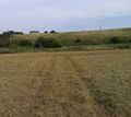
This turned out to be... exactly as easy as I thought it would be. I parked on the kerb opposite the entrance to the field, walked along the edge until I was lined up with the tree from Google Maps, and then paced the 50m across the stubble-filled field until I reached the hash.
The only real concern I had was that the ominous-looking four-wheel-drive vehicle sitting by the field might contain a mob of angry farmers with shotguns... but it didn't, so that was all right.
Photos
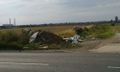
I think littering is Essex's national industry.
Will the farmer hunt me like a rabid animal? Nah, it's empty.
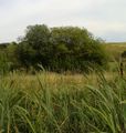
I line up on a tree...
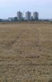
... and follow the geohashing farmer's tracks.
You thought I was joking about the farmer, didn't you? (Well, I guess I was)

I forget how zoom works.
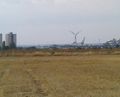
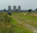
Yeah, what's with all the windmills?


What's With All The Windmills?
I've highlighted pictures of windmills in three of my last five reports (the other two being 2015-08-10 52 -3 and 2015-08-22 51 0). What's up with that?
Well... this:
Achievements
Huinesoron (talk) earned the Tilting At Hashpoints Achievement (Level 1)
|
(It goes up a level with each 3 you photograph; turbines have three blades, see.)
Huinesoron (talk) earned the Consecutive geohash achievement
|