Difference between revisions of "2015-08-28 48 9"
imported>Klaus (plans... gotta sleep now, only six hours left!) |
imported>FippeBot m (Location) |
||
| (2 intermediate revisions by one other user not shown) | |||
| Line 1: | Line 1: | ||
| − | + | [[Image:{{{image|2015-08-28_48_9_marker.jpg}}}|thumb|left]] | |
| − | |||
| − | |||
| − | |||
| − | |||
| − | |||
| − | |||
{{meetup graticule | {{meetup graticule | ||
| lat=48 | | lat=48 | ||
| Line 28: | Line 22: | ||
== Expedition == | == Expedition == | ||
| − | + | Ok, I overslept and left "only" at 7:00am. Some quite steep hills and some morning sport later, I arrived shortly after 8:00. It took longer than expected, because the GPS was acting strange, see the tracklog! But all in all, it was easy to reach, even the bushwhacking was easy this time. | |
| + | |||
| + | The way back was much easier (downhill) and took me less than 45 minutes back to Tuebingen. | ||
| + | Can't write more for now, as I still have to go to work, and it's already 9:06 now :) | ||
== Tracklog == | == Tracklog == | ||
| − | + | see below | |
== Photos == | == Photos == | ||
| − | |||
| − | |||
| − | |||
<gallery perrow="5"> | <gallery perrow="5"> | ||
| + | Image:2015-08-28_48_9_before_hash.jpg | Let's go bushwhacking (was easy this time) | ||
| + | Image:2015-08-28_48_9_proof.jpg | Proof | ||
| + | Image:2015-08-28_48_9_marker.jpg | My first marker ever! | ||
| + | Image:2015-08-28_48_9_marker2.jpg | Spot it?! | ||
| + | Image:2015-08-28_48_9_zoomlevel15.png | Tracklog | ||
</gallery> | </gallery> | ||
== Achievements == | == Achievements == | ||
{{#vardefine:ribbonwidth|800px}} | {{#vardefine:ribbonwidth|800px}} | ||
| − | |||
| − | + | {{land geohash | |
| − | + | | latitude = 48 | |
| − | + | | longitude = 9 | |
| − | + | | date = 2015-08-28 | |
| − | + | | name = [[User:Klaus|Klaus]] | |
| − | + | }} | |
| − | [[ | ||
| − | |||
| − | + | {{bicycle geohash | |
| + | | latitude = 48 | ||
| + | | longitude = 9 | ||
| + | | date = 2015-08-28 | ||
| + | | name = [[User:Klaus|Klaus]] | ||
| + | | distance = 18km | ||
| + | | bothways = true | ||
| + | }} | ||
| − | |||
[[Category:Expeditions]] | [[Category:Expeditions]] | ||
| − | |||
[[Category:Expeditions with photos]] | [[Category:Expeditions with photos]] | ||
| − | |||
| − | |||
| − | |||
| − | |||
| − | |||
[[Category:Coordinates reached]] | [[Category:Coordinates reached]] | ||
| − | + | {{location|DE|BW|TÜ}} | |
| − | |||
| − | |||
| − | |||
| − | |||
| − | |||
| − | |||
| − | |||
| − | |||
| − | |||
| − | |||
| − | |||
| − | |||
| − | |||
| − | |||
| − | |||
| − | |||
| − | |||
Latest revision as of 04:57, 15 August 2019

| Fri 28 Aug 2015 in 48,9: 48.5759198, 9.0423219 geohashing.info google osm bing/os kml crox |
Location
northwest of Bebenhausen in Schönbuch
Participants
Plans
too close from Tübingen to let go... Unfortunately, I have barely time tomorrow, but if I manage to wake up early (6:00am) , I might be able to do it by bicycle before work, ETA 7:00am at the hashpoint!
Expedition
Ok, I overslept and left "only" at 7:00am. Some quite steep hills and some morning sport later, I arrived shortly after 8:00. It took longer than expected, because the GPS was acting strange, see the tracklog! But all in all, it was easy to reach, even the bushwhacking was easy this time.
The way back was much easier (downhill) and took me less than 45 minutes back to Tuebingen. Can't write more for now, as I still have to go to work, and it's already 9:06 now :)
Tracklog
see below
Photos
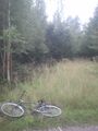
Let's go bushwhacking (was easy this time)
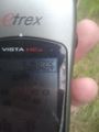
Proof
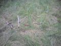
My first marker ever!
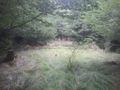
Spot it?!
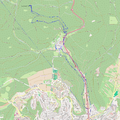
Tracklog


Achievements
Klaus earned the Land geohash achievement
|
Klaus earned the Bicycle geohash achievement
|