Difference between revisions of "2015-08-29 34 -118"
imported>Erik r (Created page with "{{subst:Expedition |lat = 34|lon = -118|date = 2015-08-29}}") |
imported>FippeBot m (Location) |
||
| (6 intermediate revisions by 2 users not shown) | |||
| Line 1: | Line 1: | ||
| − | |||
| − | [[Image:{{{image|IMAGE}}}|thumb|left]] | + | <!--[[Image:{{{image|IMAGE}}}|thumb|left]]--> |
| − | |||
| − | |||
| − | |||
| − | |||
| − | |||
{{meetup graticule | {{meetup graticule | ||
| lat=34 | | lat=34 | ||
| Line 15: | Line 9: | ||
}} | }} | ||
| − | |||
| − | |||
== Location == | == Location == | ||
| − | + | In the bush off of a trail near the Topanga Tower. Might be tough to reach through the brush. | |
== Participants == | == Participants == | ||
| − | + | ||
| − | + | * [[User:Erik r|Erik r]] and | |
| + | * his dad | ||
== Plans == | == Plans == | ||
| − | + | Will hike up to the nearest point on the trail, either from Red Rock Canyon Park or the Topanga Tower, not yet decided. Then going to attempt to fight through the brush to the hash point. Hope to get there before noon. | |
== Expedition == | == Expedition == | ||
| − | + | My dad and I left around 8 from home, driving to Red Rock Canyon Park. We walked from there up the trail, planning to make a nice morning hike out of the expedition. Eventually we reached the nearest on-trail point to the hash point, and I quested into the brush. It was too thick though to easily get through (as expected) and I hadn't brought proper fighting-through-aggressive-chapparal-clothing. I got to within maybe 100m of the point - the best estimate I had was "0.1 miles" from the Iphone app I was using - and quickly decided to turn back. We finished our hike, about 10 miles in total, which was nice. Shame to now have a 40% lifetime success rate with reaching the coordinates, but hey, we had a great time. | |
| − | |||
| − | |||
| − | |||
== Photos == | == Photos == | ||
| − | |||
| − | |||
| − | |||
<gallery perrow="5"> | <gallery perrow="5"> | ||
| + | Image:2015_08_29_34_-118_view.jpg|In we go | ||
| + | Image:2015_08_29_34_-118_gps.jpg|Closest I got | ||
| + | Image:2015_08_29_34_-118_me.jpg|At closest approach | ||
| + | Image:2015_08_29_34_-118_closest.jpg|View from nearest spot | ||
</gallery> | </gallery> | ||
| − | |||
| − | |||
| − | |||
| − | |||
| − | |||
| − | |||
| − | |||
| − | |||
| − | |||
| − | |||
| − | |||
| − | |||
| − | |||
| − | |||
| − | |||
[[Category:Expeditions]] | [[Category:Expeditions]] | ||
| − | |||
[[Category:Expeditions with photos]] | [[Category:Expeditions with photos]] | ||
| − | |||
| − | |||
| − | |||
| − | |||
| − | |||
| − | |||
| − | |||
| − | |||
| − | |||
[[Category:Coordinates not reached]] | [[Category:Coordinates not reached]] | ||
| − | |||
| − | |||
[[Category:Not reached - Mother Nature]] | [[Category:Not reached - Mother Nature]] | ||
| − | + | {{location|US|CA|LO}} | |
| − | |||
| − | |||
| − | |||
| − | |||
| − | |||
| − | |||
| − | |||
| − | |||
| − | |||
| − | |||
Latest revision as of 04:58, 15 August 2019
| Sat 29 Aug 2015 in 34,-118: 34.0895303, -118.6387050 geohashing.info google osm bing/os kml crox |
Contents
Location
In the bush off of a trail near the Topanga Tower. Might be tough to reach through the brush.
Participants
- Erik r and
- his dad
Plans
Will hike up to the nearest point on the trail, either from Red Rock Canyon Park or the Topanga Tower, not yet decided. Then going to attempt to fight through the brush to the hash point. Hope to get there before noon.
Expedition
My dad and I left around 8 from home, driving to Red Rock Canyon Park. We walked from there up the trail, planning to make a nice morning hike out of the expedition. Eventually we reached the nearest on-trail point to the hash point, and I quested into the brush. It was too thick though to easily get through (as expected) and I hadn't brought proper fighting-through-aggressive-chapparal-clothing. I got to within maybe 100m of the point - the best estimate I had was "0.1 miles" from the Iphone app I was using - and quickly decided to turn back. We finished our hike, about 10 miles in total, which was nice. Shame to now have a 40% lifetime success rate with reaching the coordinates, but hey, we had a great time.
Photos
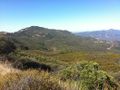
In we go
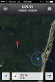
Closest I got

At closest approach
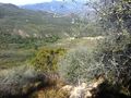
View from nearest spot


