Difference between revisions of "2015-09-03 51 0"
imported>Sourcerer m (→Achievements) |
m |
||
| (14 intermediate revisions by 2 users not shown) | |||
| Line 3: | Line 3: | ||
| lon=0 | | lon=0 | ||
| date=2015-09-03 | | date=2015-09-03 | ||
| + | | graticule_name=London East, UK | ||
| + | | graticule_link=London East, United Kingdom | ||
}} | }} | ||
__NOTOC__ | __NOTOC__ | ||
| − | |||
== Location == | == Location == | ||
| − | In a field, east of Curling Tye Green, Essex, UK. | + | 2) In a field, east of Curling Tye Green, Essex, UK - [http://w3w.co/placed.smarting.stitching placed.smarting.stitching] |
== Participants == | == Participants == | ||
| Line 18: | Line 19: | ||
Sourcerer is visiting east Kent in [[Canterbury, United Kingdom]]. This is close to the route. ETA 11 am or perhaps noon. | Sourcerer is visiting east Kent in [[Canterbury, United Kingdom]]. This is close to the route. ETA 11 am or perhaps noon. | ||
| − | == Expedition == | + | == Expedition - Fail == |
| + | *No access. Ploughing in progress. -- [[User:Sourcerer|Sourcerer]] ([[User talk:Sourcerer|talk]]) [http://www.openstreetmap.org/?lat=51.73287034&lon=.64255536&zoom=16&layers=B000FTF @51.7329,.6426] 12:59, 3 September 2015 (GMT+01:00) | ||
| + | This was not a success. If I'd been an hour earlier, it would have better. The ploughing would not have started and it would have been an easy stubble field. So I decided not to play dodge-the-plough and make the tractor driver angry. I took a photo and left. | ||
| + | Now I'm on the cloud WiFi at the University of Kent at Canterbury re-visiting 40 years after I was a student there. | ||
| + | * Back in the day, the Internet just about existed with ASCII text only. | ||
| + | * I learned some programming on an Elliot 4130 ("not available now"). It was a multi-user system with paper roll mechanical terminals. | ||
| + | * I learned how to make beer. Bought beer was too expensive for students. This is legal in the UK. Distilling is not! | ||
| − | |||
== Photos == | == Photos == | ||
<gallery perrow="5"> | <gallery perrow="5"> | ||
| − | |||
| − | |||
Image:2015-09-03_51_0_Sourcerer_1441281650310.jpg | Closest approach. [http://www.openstreetmap.org/?lat=51.73287034&lon=.64255536&zoom=16&layers=B000FTF @51.7329,.6426] | Image:2015-09-03_51_0_Sourcerer_1441281650310.jpg | Closest approach. [http://www.openstreetmap.org/?lat=51.73287034&lon=.64255536&zoom=16&layers=B000FTF @51.7329,.6426] | ||
| − | |||
Image:2015-09-03_51_0_Sourcerer_1441281587771.jpg | Tractor and plough at hashpoint. [http://www.openstreetmap.org/?lat=51.73288107&lon=.64255536&zoom=16&layers=B000FTF @51.7329,.6426] | Image:2015-09-03_51_0_Sourcerer_1441281587771.jpg | Tractor and plough at hashpoint. [http://www.openstreetmap.org/?lat=51.73288107&lon=.64255536&zoom=16&layers=B000FTF @51.7329,.6426] | ||
| + | Image:2015-09-03 51 0 Sourcerer.jpg | Track in Google Earth | ||
</gallery> | </gallery> | ||
== Achievements == | == Achievements == | ||
{{#vardefine:ribbonwidth|700px}} | {{#vardefine:ribbonwidth|700px}} | ||
| − | |||
{{Sourcerer_links | {{Sourcerer_links | ||
| prev = 2015-09-03 52 1 | | prev = 2015-09-03 52 1 | ||
| curr = 2015-09-03 51 0 | | curr = 2015-09-03 51 0 | ||
| − | | next = 2015-09- | + | | next = 2015-09-07 51 0 |
| date = 2015-09-03 | | date = 2015-09-03 | ||
}} | }} | ||
| Line 48: | Line 51: | ||
[[Category:Expeditions with photos]] | [[Category:Expeditions with photos]] | ||
[[Category:Coordinates not reached]] | [[Category:Coordinates not reached]] | ||
| + | [[Category:Not reached - No public access]] | ||
| + | {{location|GB|ENG|ESS}} | ||
Latest revision as of 09:28, 28 March 2022
| Thu 3 Sep 2015 in London East, UK: 51.7331961, 0.6424850 geohashing.info google osm bing/os kml crox |
Location
2) In a field, east of Curling Tye Green, Essex, UK - placed.smarting.stitching
Participants
Plans
Sourcerer is visiting east Kent in Canterbury, United Kingdom. This is close to the route. ETA 11 am or perhaps noon.
Expedition - Fail
- No access. Ploughing in progress. -- Sourcerer (talk) @51.7329,.6426 12:59, 3 September 2015 (GMT+01:00)
This was not a success. If I'd been an hour earlier, it would have better. The ploughing would not have started and it would have been an easy stubble field. So I decided not to play dodge-the-plough and make the tractor driver angry. I took a photo and left.
Now I'm on the cloud WiFi at the University of Kent at Canterbury re-visiting 40 years after I was a student there.
- Back in the day, the Internet just about existed with ASCII text only.
- I learned some programming on an Elliot 4130 ("not available now"). It was a multi-user system with paper roll mechanical terminals.
- I learned how to make beer. Bought beer was too expensive for students. This is legal in the UK. Distilling is not!
Photos
Closest approach. @51.7329,.6426
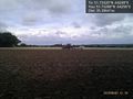
Tractor and plough at hashpoint. @51.7329,.6426
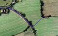
Track in Google Earth


Achievements
Expeditions and Plans
| 2015-09-03 | ||
|---|---|---|
| Portland, Oregon | Michael5000, Jim | On a street in the 60s, just north of the Banfield. |
| Mannheim, Germany | Tads | Almost on top of the Melibokus hill, in a wood close to Alsbach-Hähnlein. |
| London East, United Kingdom | Sourcerer | 2) In a field, east of Curling Tye Green, Essex, UK - placed.smarting.stitching... |
| Norwich, United Kingdom | Sourcerer | 1) erase.buzz.shame = a field south of Horsey Wind pump, Norfolk, UK. |
Sourcerer's Expedition Links
2015-09-03 52 1 - 2015-09-03 51 0 - 2015-09-07 51 0 - KML file download of Sourcerer's expeditions for use with Google Earth.