Difference between revisions of "2015-08-28 47 19"
imported>Codae (Created page with "{{subst:Expedition |lat = 47 |lon = 19 |date = 2015-08-28 }}") |
imported>FippeBot m (Location) |
||
| (One intermediate revision by one other user not shown) | |||
| Line 20: | Line 20: | ||
== Location == | == Location == | ||
<!-- where you've surveyed the hash to be --> | <!-- where you've surveyed the hash to be --> | ||
| + | In a field in Óbuda, Budapest, Hungary. | ||
== Participants == | == Participants == | ||
<!-- who attended: If you link to your wiki user name in this section, your expedition will be picked up by the various statistics generated for geohashing. You may use three tildes ~ as a shortcut to automatically insert the user signature of the account you are editing with. | <!-- who attended: If you link to your wiki user name in this section, your expedition will be picked up by the various statistics generated for geohashing. You may use three tildes ~ as a shortcut to automatically insert the user signature of the account you are editing with. | ||
--> | --> | ||
| + | [[User:Codae|Codae]] | ||
| + | |||
| + | Abel | ||
| + | |||
| + | Sean | ||
== Plans == | == Plans == | ||
<!-- what were the original plans --> | <!-- what were the original plans --> | ||
| + | Head out to the area by metro and suburban rail, walk through some woods to the geohash, and return home the same way. | ||
== Expedition == | == Expedition == | ||
<!-- how it all turned out. your narrative goes here. --> | <!-- how it all turned out. your narrative goes here. --> | ||
| + | The transport part of the expedition went off without a hitch, save some confusion about where, relative to the hashpoint, the exit to the Rómaifürdő station was. It turned out it was in the best possible location, on Prés utca, right where the path through the forest seemed to be. We paused at this point--Codae to get the GPS working after a six-thousand-mile relocation, and Sean and Abel to pet a cat. | ||
| + | |||
| + | We detoured from the primary route through the forest due to apprehension about its public status (there were people hanging out on it, and we didn't feel like dealing with them with our limited Hungarian), but found a pleasant trail that took us pretty much right where we wanted to go. The hashpoint was by the edge of the woods a bit south of where we emerged. A ditch separated us from the trees, but before long the GPS was registering the geohash on the mown strip of grass between the ditch and the unkempt field, so we collected it there. | ||
| + | |||
| + | Then we explored the territory some more, finding some livestock and a segment of an interpretive trail around the meadow. One of us, interested in whether a recurring plant was a stinging nettle, tested it himself and found that it was. Then we walked back to the train station, on the primary route this time (with, as it turns out, no accostations from the locals), and headed home. | ||
== Tracklog == | == Tracklog == | ||
| Line 39: | Line 51: | ||
--> | --> | ||
<gallery perrow="5"> | <gallery perrow="5"> | ||
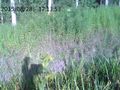
| + | Image:2015-08-28 47 19 Proof.JPG | Success! | ||
| + | Image:2015-08-28 47 19 Field.JPG | Looking south from the hashpoint. | ||
| + | Image:2015-08-28 47 19 Ditch.JPG | If the geohash had wandered east into the woods, this would have been a barrier. As it is, it just supplied us with wildlife to observe (frogs, a snake, something well-hidden in the underbrush on the bank). | ||
| + | Image:2015-08-28 47 19 Group.JPG | Group photo. | ||
</gallery> | </gallery> | ||
| Line 44: | Line 60: | ||
{{#vardefine:ribbonwidth|800px}} | {{#vardefine:ribbonwidth|800px}} | ||
<!-- Add any achievement ribbons you earned below, or remove this section --> | <!-- Add any achievement ribbons you earned below, or remove this section --> | ||
| + | {{Land geohash|latitude=47|longitude=19|date=2015-08-28|name=Codae, Abel, and Sean}} | ||
| + | {{Public transport geohash|latitude=47|longitude=19|date=2015-08-28|name=Codae, Abel, and Sean}} | ||
| + | {{Globetrotter6|northamerica=true|europe=true|continents=2|name=Codae}} | ||
| + | {{Drag-along|latitude=47|longitude=19|date=2015-08-28|name=Codae}} | ||
| + | {{Hashcat|latitude=47|longitude=19|date=2015-08-28|name=Abel and Sean (sadly, without proof)}} | ||
<!-- =============== USEFUL CATEGORIES FOLLOW ================ | <!-- =============== USEFUL CATEGORIES FOLLOW ================ | ||
Delete the next line ONLY if you have chosen the appropriate categories below. If you are unsure, don't worry. People will read your report and help you with the classification. --> | Delete the next line ONLY if you have chosen the appropriate categories below. If you are unsure, don't worry. People will read your report and help you with the classification. --> | ||
| − | + | ||
<!-- Potential categories. Please include all the ones appropriate to your expedition --> | <!-- Potential categories. Please include all the ones appropriate to your expedition --> | ||
| − | |||
| − | |||
| − | |||
| − | + | [[Category:Expeditions]] | |
| − | |||
| − | |||
| − | |||
[[Category:Expeditions with photos]] | [[Category:Expeditions with photos]] | ||
| − | + | ||
| − | |||
| − | |||
| − | |||
| − | |||
[[Category:Coordinates reached]] | [[Category:Coordinates reached]] | ||
| − | + | {{location|HU|BU}} | |
| − | |||
| − | |||
| − | |||
| − | |||
| − | |||
| − | |||
| − | |||
| − | |||
| − | |||
| − | |||
| − | |||
| − | |||
| − | |||
| − | |||
| − | |||
| − | |||
| − | |||
Latest revision as of 04:57, 15 August 2019
| Fri 28 Aug 2015 in 47,19: 47.5759198, 19.0423219 geohashing.info google osm bing/os kml crox |
Location
In a field in Óbuda, Budapest, Hungary.
Participants
Abel
Sean
Plans
Head out to the area by metro and suburban rail, walk through some woods to the geohash, and return home the same way.
Expedition
The transport part of the expedition went off without a hitch, save some confusion about where, relative to the hashpoint, the exit to the Rómaifürdő station was. It turned out it was in the best possible location, on Prés utca, right where the path through the forest seemed to be. We paused at this point--Codae to get the GPS working after a six-thousand-mile relocation, and Sean and Abel to pet a cat.
We detoured from the primary route through the forest due to apprehension about its public status (there were people hanging out on it, and we didn't feel like dealing with them with our limited Hungarian), but found a pleasant trail that took us pretty much right where we wanted to go. The hashpoint was by the edge of the woods a bit south of where we emerged. A ditch separated us from the trees, but before long the GPS was registering the geohash on the mown strip of grass between the ditch and the unkempt field, so we collected it there.
Then we explored the territory some more, finding some livestock and a segment of an interpretive trail around the meadow. One of us, interested in whether a recurring plant was a stinging nettle, tested it himself and found that it was. Then we walked back to the train station, on the primary route this time (with, as it turns out, no accostations from the locals), and headed home.
Tracklog
Photos

Success!
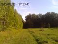
Looking south from the hashpoint.
If the geohash had wandered east into the woods, this would have been a barrier. As it is, it just supplied us with wildlife to observe (frogs, a snake, something well-hidden in the underbrush on the bank).
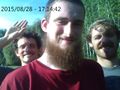
Group photo.


Achievements
Codae, Abel, and Sean earned the Land geohash achievement
|
Codae, Abel, and Sean earned the Public transport geohash achievement
|
Codae earned the Globetrotter achievement
|
Codae earned the Drag-along achievement
|
Abel and Sean (sadly, without proof) earned the Hashcat achievement
|