Difference between revisions of "2015-09-11 48 9"
imported>Klaus (template) |
imported>FippeBot m (Location) |
||
| (6 intermediate revisions by 2 users not shown) | |||
| Line 1: | Line 1: | ||
| + | [[Image:{{{image|2015-09-11_48_9_klaus_1m_to_geohash.jpg}}}|thumb|left]] | ||
| − | |||
| − | |||
| − | |||
| − | |||
| − | |||
| − | |||
| − | |||
| − | |||
| − | |||
{{meetup graticule | {{meetup graticule | ||
| lat=48 | | lat=48 | ||
| Line 15: | Line 7: | ||
}} | }} | ||
| − | |||
__NOTOC__ | __NOTOC__ | ||
== Location == | == Location == | ||
| − | + | on the northern track of the railway between Tuebingen and Reutlingen | |
== Participants == | == Participants == | ||
| − | + | * [[User:Klaus|Klaus]] | |
| − | + | * [[User:Ekorren|Ekorren]] | |
== Plans == | == Plans == | ||
| − | <! | + | Klaus will buy a Naldo day ticket (zone 2) for 5.80 Euro and take <strike>the RE 22020 from Tuebingen Hbf (8:05) -> Reutlingen Hbf (8:16). |
| + | After arriving in Reutlingen, he'll take the next Train RB 22907 from Reutlingen Hbf (8:29) back to Tuebingen Hbf (8:44).</strike> the IRE 3270 from Tuebingen Hbf (7:57) to Reutlingen Hbf (8:06). After arriving in Reutlingen, he'll take the next train back (RE 22011, 8:12) and will arrive at Tuebingen at 8:23. | ||
| + | The second train should (according to the train expert Ekorren) use the correct northern track and thus qualify for the geohash. | ||
| + | |||
| + | Afterwards, Klaus and Ekorren will meet up at the train station in Tuebingen at 8:23! We plan to chat a few minutes, then Klaus will have to go to work and give Ekorren the ticket, so he can do the geohash, too. | ||
| + | |||
| + | [[User:Ekorren|Ekorren]] will try to catch the 11:15 from Tübingen to Reutlingen which arrives 11:29 at Reutlingen West. There he plans to take a look at the hash from the platform, a short detour into the inner city, and then catch a train back between 12:00 and 13:00. | ||
== Expedition == | == Expedition == | ||
| − | + | ||
| + | === Klaus === | ||
| + | [[User:Klaus|Klaus]] had some problems with this stupid ticket vending machine called "DB Automat". | ||
| + | He normally buys tickets exclusively online... | ||
| + | The "DB Automat" wouldn't give him a Naldo dayticket for zone 2, but instead offer him either a dayticket for the complete zone (too expensive) or just a single ticket from Tuebingen to Reutlingen :( | ||
| + | Some *NSFW* curse words later he got it, but was 5 seconds too late and the IRE had already his doors closed. | ||
| + | |||
| + | So Klaus had to take the original (striken through) plan from above. | ||
| + | Using the RE 22020, he went to Reutlingen seamlessly. | ||
| + | Then waiting 13 minutes, he noticed that the original plan was stupid anyway: When taking the RB 22907 back, this train would stop at "Reutlingen West" and give him more time to take proof photos! | ||
| + | And actually, the GPS told him that he was sitting exactly* at the geohash location, when the train stopped at "Reutlingen West"! (* exactly means +- 1 metre) | ||
| + | |||
| + | After arriving in Tuebingen, Klaus immediately noticed Ekorren who was already waiting at the door in the station. | ||
| + | We talked about geohashing, other stuff and more other stuff and slowly walked to the place where Klaus works. | ||
| + | Finally, at around 9:30, Klaus started working and had a rather uninteresting day remaining ... | ||
| + | Ekorren drove back with his bicycle to start his own expedition! | ||
== Tracklog == | == Tracklog == | ||
| − | + | [https://www.youtube.com/watch?v=zGxwbhkDjZM ain't nobody got time for that]... and of course, it would be quite boring: just following a railway track! | |
== Photos == | == Photos == | ||
| − | |||
| − | |||
| − | |||
<gallery perrow="5"> | <gallery perrow="5"> | ||
| + | Image:2015-09-11_48_9_klaus_ticket.jpg | Who wouldn't pay 5,80 just to sit 40min in a train? | ||
| + | Image:2015-09-11_48_9_klaus_1m_to_geohash.jpg | Damn, I should have taken the seat 1m behind me... But the geohash wouldn't look different anyway :) Notice that I intentionally took the left side of the train to get over the geohash! | ||
| + | Image:2015-09-11_48_9_klaus_coordinates.jpg | more proof! | ||
| + | Image:2015-09-11_48_9_klaus_dejavuproof.png | even more proof for DejaVu! | ||
</gallery> | </gallery> | ||
| + | |||
== Achievements == | == Achievements == | ||
| + | |||
{{#vardefine:ribbonwidth|800px}} | {{#vardefine:ribbonwidth|800px}} | ||
| − | |||
| − | + | === Klaus === | |
| − | + | {{land geohash | |
| − | [[ | + | | latitude = 48 |
| + | | longitude = 9 | ||
| + | | date = 2015-09-11 | ||
| + | | name = [[User:Klaus|Klaus]] | ||
| + | }} | ||
| + | |||
| + | {{Public transport geohash | ||
| + | | latitude = 48 | ||
| + | | longitude = 9 | ||
| + | | date = 2015-09-11 | ||
| + | | busline = RE 22020 and RB 22907 | ||
| + | | name = [[User:Klaus|Klaus]] | ||
| + | }} | ||
| + | |||
| + | {{Admit One geohash | ||
| + | | latitude = 48 | ||
| + | | longitude = 9 | ||
| + | | date = 2015-09-11 | ||
| + | | name = [[User:Klaus|Klaus]] | ||
| + | | price = 5,80 EUR | ||
| + | | venue = the northern railway track belonging to "Deutsche Bahn" from Reutlingen to Tuebingen | ||
| + | | image = 2015-09-11_48_9_klaus_ticket.jpg | ||
| + | }} | ||
| − | + | {{Déjà vu geohash | |
| − | + | | latitude = 48 | |
| − | [[ | + | | longitude = 9 |
| − | -- | + | | date = 2015-09-11 |
| + | | name = [[User:Klaus|Klaus]] | ||
| + | | olddate = 2015-07-19 | ||
| + | | image = 2015-09-11_48_9_klaus_dejavuproof.png | ||
| + | }} | ||
| − | + | not sure, if I get the meetup achievement as we didn't meet at the geohash! | |
| − | |||
[[Category:Expeditions]] | [[Category:Expeditions]] | ||
| − | |||
[[Category:Expeditions with photos]] | [[Category:Expeditions with photos]] | ||
| − | |||
| − | |||
| − | |||
| − | |||
[[Category:Coordinates reached]] | [[Category:Coordinates reached]] | ||
| − | + | {{location|DE|BW|RT}} | |
| − | |||
| − | |||
| − | |||
| − | |||
| − | |||
| − | |||
| − | |||
| − | |||
| − | |||
| − | |||
| − | |||
| − | |||
| − | |||
| − | |||
| − | |||
| − | |||
| − | |||
Latest revision as of 05:05, 15 August 2019

| Fri 11 Sep 2015 in 48,9: 48.4925934, 9.2019514 geohashing.info google osm bing/os kml crox |
Location
on the northern track of the railway between Tuebingen and Reutlingen
Participants
Plans
Klaus will buy a Naldo day ticket (zone 2) for 5.80 Euro and take the RE 22020 from Tuebingen Hbf (8:05) -> Reutlingen Hbf (8:16).
After arriving in Reutlingen, he'll take the next Train RB 22907 from Reutlingen Hbf (8:29) back to Tuebingen Hbf (8:44). the IRE 3270 from Tuebingen Hbf (7:57) to Reutlingen Hbf (8:06). After arriving in Reutlingen, he'll take the next train back (RE 22011, 8:12) and will arrive at Tuebingen at 8:23.
The second train should (according to the train expert Ekorren) use the correct northern track and thus qualify for the geohash.
Afterwards, Klaus and Ekorren will meet up at the train station in Tuebingen at 8:23! We plan to chat a few minutes, then Klaus will have to go to work and give Ekorren the ticket, so he can do the geohash, too.
Ekorren will try to catch the 11:15 from Tübingen to Reutlingen which arrives 11:29 at Reutlingen West. There he plans to take a look at the hash from the platform, a short detour into the inner city, and then catch a train back between 12:00 and 13:00.
Expedition
Klaus
Klaus had some problems with this stupid ticket vending machine called "DB Automat". He normally buys tickets exclusively online... The "DB Automat" wouldn't give him a Naldo dayticket for zone 2, but instead offer him either a dayticket for the complete zone (too expensive) or just a single ticket from Tuebingen to Reutlingen :( Some *NSFW* curse words later he got it, but was 5 seconds too late and the IRE had already his doors closed.
So Klaus had to take the original (striken through) plan from above. Using the RE 22020, he went to Reutlingen seamlessly. Then waiting 13 minutes, he noticed that the original plan was stupid anyway: When taking the RB 22907 back, this train would stop at "Reutlingen West" and give him more time to take proof photos! And actually, the GPS told him that he was sitting exactly* at the geohash location, when the train stopped at "Reutlingen West"! (* exactly means +- 1 metre)
After arriving in Tuebingen, Klaus immediately noticed Ekorren who was already waiting at the door in the station. We talked about geohashing, other stuff and more other stuff and slowly walked to the place where Klaus works. Finally, at around 9:30, Klaus started working and had a rather uninteresting day remaining ... Ekorren drove back with his bicycle to start his own expedition!
Tracklog
ain't nobody got time for that... and of course, it would be quite boring: just following a railway track!
Photos
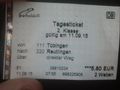
Who wouldn't pay 5,80 just to sit 40min in a train?
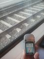
Damn, I should have taken the seat 1m behind me... But the geohash wouldn't look different anyway :) Notice that I intentionally took the left side of the train to get over the geohash!
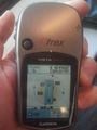
more proof!
even more proof for DejaVu!


Achievements
Klaus
Klaus earned the Land geohash achievement
|
Klaus earned the Public transport geohash achievement
|
Klaus earned the Admit One Achievement
|
Klaus earned the Déjà Vu Geohash Achievement
|
not sure, if I get the meetup achievement as we didn't meet at the geohash!