Difference between revisions of "2015-10-19 48 9"
imported>Klaus (documented my expedition) |
imported>FippeBot m (Location) |
||
| (4 intermediate revisions by one other user not shown) | |||
| Line 1: | Line 1: | ||
| − | + | [[Image:{{{image|2015-10-19_48_9_bicycle.jpg}}}|thumb|left]] | |
| − | |||
| − | |||
| − | |||
| − | |||
| − | |||
| − | |||
| − | |||
{{meetup graticule | {{meetup graticule | ||
| lat=48 | | lat=48 | ||
| Line 33: | Line 26: | ||
The evening before I wanted to geohash, I noticed that I forgot my Garmin GPS at my parents place a few hundred kilometers away. | The evening before I wanted to geohash, I noticed that I forgot my Garmin GPS at my parents place a few hundred kilometers away. | ||
So I didn't set the alarm and went to work as usual. | So I didn't set the alarm and went to work as usual. | ||
| − | During the work, I thought that maybe I can download the | + | During the work, I thought that maybe I can download the geohashing app and do it with my smartphone. |
| − | + | I left work at around 17:30 and went straight to my home, changing into some warm sporting cloths and left for my geohash expedition at 18:00. | |
The problem was that the sunset was at 18:29 today and I arrived at around 18:40 at the geohash. | The problem was that the sunset was at 18:29 today and I arrived at around 18:40 at the geohash. | ||
| − | Of course, the stupid smartphone took 5 minutes to get a GPS signal, so it was | + | Of course, the stupid smartphone took 5 minutes to get a GPS signal, so it was the end of the twilight time when I finally arrived at the geohash at 18:50 and I had to use my (expensive, but good) headlight to get a not completly dark photo. |
Nothing spectacular at the geohash, but all in all a nice 1:30 bike trip. | Nothing spectacular at the geohash, but all in all a nice 1:30 bike trip. | ||
| − | + | And I noticed two cats on my way back to Tuebingen! (which is easy in the dark with a headlight, just look for the devil eyes) | |
| − | And I noticed two cats on my way back to Tuebingen (which is easy in the dark with a headlight, just look for the devil eyes) | ||
I patted one of them, but after reading the requirement for the [[Hashcat_achievement]] again, I may not have qualified, because it was close to Tuebingen and thus not close to the geohash :( | I patted one of them, but after reading the requirement for the [[Hashcat_achievement]] again, I may not have qualified, because it was close to Tuebingen and thus not close to the geohash :( | ||
| Line 54: | Line 46: | ||
Image:2015-10-19_48_9_proof.jpg | Proof (closest I got was 5 meter) | Image:2015-10-19_48_9_proof.jpg | Proof (closest I got was 5 meter) | ||
Image:2015-10-19_48_9_bruehlbaechle.jpg | The Brühlbächle I had to cross | Image:2015-10-19_48_9_bruehlbaechle.jpg | The Brühlbächle I had to cross | ||
| + | Image:2015-10-19_48_9_not_a_hashcat.jpg | not a hashcat, but a normal one (and probably quite blinded by the light, so I left his/her) | ||
</gallery> | </gallery> | ||
| Line 59: | Line 52: | ||
{{#vardefine:ribbonwidth|800px}} | {{#vardefine:ribbonwidth|800px}} | ||
<!-- Add any achievement ribbons you earned below, or remove this section --> | <!-- Add any achievement ribbons you earned below, or remove this section --> | ||
| + | |||
| + | {{land geohash | ||
| + | | latitude = 48 | ||
| + | | longitude = 9 | ||
| + | | date = 2015-10-19 | ||
| + | | name = [[User:Klaus|Klaus]] | ||
| + | }} | ||
| + | |||
| + | {{bicycle geohash | ||
| + | | latitude = 48 | ||
| + | | longitude = 9 | ||
| + | | date = 2015-10-19 | ||
| + | | name = [[User:Klaus|Klaus]] | ||
| + | | distance = 18km | ||
| + | | bothways = true | ||
| + | }} | ||
| + | |||
| + | {{Radio Yerevan | ||
| + | | achievement = [[Hashcat_achievement]] | ||
| + | | detail = none of the two cats met on the way back can be considered as near to the geohash | ||
| + | | date = 2015-10-19 | ||
| + | | latitude = 48 | ||
| + | | longitude = 9 | ||
| + | | user = [[User:Klaus|Klaus]] | ||
| + | | image = 2015-10-19_48_9_not_a_hashcat.jpg | ||
| + | }} | ||
[[Category:Expeditions]] | [[Category:Expeditions]] | ||
[[Category:Expeditions with photos]] | [[Category:Expeditions with photos]] | ||
| − | |||
[[Category:Coordinates reached]] | [[Category:Coordinates reached]] | ||
| + | {{location|DE|BW|TÜ}} | ||
Latest revision as of 05:30, 15 August 2019

| Mon 19 Oct 2015 in 48,9: 48.5751203, 9.0535245 geohashing.info google osm bing/os kml crox |
Location
northwest of Bebenhausen in Schönbuch (again!)
Participants
Plans
This one is very near to 2015-08-28 48 9. The plan is identical to last time: Wake up early, do some morning sports and go to work afterwards. ETA at Geohash: 7:30 - 8:00 CEST! -- klaus
- Well, I won't join in at that time. Might go later during the day, but probably not. --Ekorren (talk) 11:21, 17 October 2015 (EDT)
Expedition
The evening before I wanted to geohash, I noticed that I forgot my Garmin GPS at my parents place a few hundred kilometers away. So I didn't set the alarm and went to work as usual. During the work, I thought that maybe I can download the geohashing app and do it with my smartphone. I left work at around 17:30 and went straight to my home, changing into some warm sporting cloths and left for my geohash expedition at 18:00. The problem was that the sunset was at 18:29 today and I arrived at around 18:40 at the geohash.
Of course, the stupid smartphone took 5 minutes to get a GPS signal, so it was the end of the twilight time when I finally arrived at the geohash at 18:50 and I had to use my (expensive, but good) headlight to get a not completly dark photo.
Nothing spectacular at the geohash, but all in all a nice 1:30 bike trip. And I noticed two cats on my way back to Tuebingen! (which is easy in the dark with a headlight, just look for the devil eyes) I patted one of them, but after reading the requirement for the Hashcat_achievement again, I may not have qualified, because it was close to Tuebingen and thus not close to the geohash :(
Tracklog
none this time, but very similiar to the one of 2015-08-28 48 9.
Photos
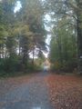
Nice forest road, only a few hundred meters left to the geohash
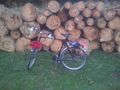
My bicycle and the smartphone on the saddle waiting for GPS signal
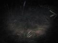
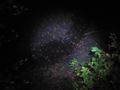
The geohash (or just some random grass 5 meters next to it)
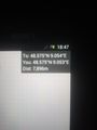
Proof (closest I got was 5 meter)
The Brühlbächle I had to cross
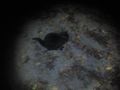
not a hashcat, but a normal one (and probably quite blinded by the light, so I left his/her)


Achievements
Klaus earned the Land geohash achievement
|
Klaus earned the Bicycle geohash achievement
|
Is it true that Klaus earned the Hashcat_achievement?
|