Difference between revisions of "2015-11-02 49 8"
imported>Lord Vetinari (→Participants) |
imported>FippeBot m (Location) |
||
| (17 intermediate revisions by 2 users not shown) | |||
| Line 26: | Line 26: | ||
<!-- who attended: If you link to your wiki user name in this section, your expedition will be picked up by the various statistics generated for geohashing. You may use three tildes ~ as a shortcut to automatically insert the user signature of the account you are editing with. | <!-- who attended: If you link to your wiki user name in this section, your expedition will be picked up by the various statistics generated for geohashing. You may use three tildes ~ as a shortcut to automatically insert the user signature of the account you are editing with. | ||
--> | --> | ||
| − | [[User:Lord_Vetinari|Lord Vetinari]] | + | *[[User:Lord_Vetinari|Lord Vetinari]] |
| + | *[[User:DODO|DODO]] | ||
== Plans == | == Plans == | ||
<!-- what were the original plans --> | <!-- what were the original plans --> | ||
| + | I intended to make a short detour to the hash from the nearby A5. | ||
| + | This was to be my first hash. I had occasionally checked daily position of hashes near me, but never saw one that was close enough when I had the time. | ||
== Expedition == | == Expedition == | ||
<!-- how it all turned out. your narrative goes here. --> | <!-- how it all turned out. your narrative goes here. --> | ||
| + | ===[[User:Lord_Vetinari|Lord Vetinari]]s expedition=== | ||
| + | Well armed for this first expedition (i.e. remembered to bring hiking boots suitable for the muddy fields), I originally intended to approach the hash from the south. I parked near some farmhouses located there, but soon realized I had missed the Landgraben on my quick check of the map. | ||
| − | == | + | For the second attempt, I parked north of the Leimbach, near a bridge to make a second approach from the west. This was more successful. There wasn't really a footpath, but some people seemed to have walked on the stream's south bank before. After a few hundred meters I had already reach the correct longitude. About 10 meters into the field (just barren earth at this time) the correct latitude was reached as well. |
| − | + | ||
| + | After a few circles (till my phone's GPS had settled on the correct position) I marked the place of the hash with an X. Halfway into photo taking my phone suddenly shut down. Apparently the cold made the battery drop from 40 to 0 percent. In the meantime it was already getting dark. Winter really is coming. | ||
| + | |||
| + | I'm sure this wasn't my last geohash and I'll be keeping an eye open for the next ones. | ||
| + | |||
| + | ===[[User:DODO|DODO]]s expediton=== | ||
| + | This hash is only 6 KM from my office and so I just have to try. So I started on my bull at half past seven in the morning. It was quite foggy but that didn’t matter in the town. After I’ve crossed the river rhine I had to ride through the fields and now I had to stop several times because my glasses got so wet that I couldn’t see anything anymore. Nevertheless I came close the hashpoint at half past eight. It lays on a field spanning between two rivulets, the Landgraben and the Leimbach.(as Lord Vetinari mentioned before). I stood near the Landgraben in the south and the hash was 150 m away near the Leimbach in the northern part of the field (I could hardly look that far because of the fog). | ||
| + | |||
| + | I drove some 200 m further along the field to find a better way through it (or along the edge of it), but I didn’t reach the end of it and the only thing I found was a tracktor-track which seemed to be a little bit less muddy. To my surprise the ground proved to be much harder than it looked and so I reached the hashpoint pretty fast and quite clean (or at least with only a little mud at my shoes). | ||
| + | |||
| + | I took some pictures of the fog, returned to my bull and continued my ride to my office. Unfortunatly I didn't left a mark. I didn't expect any other hasher today. I hope I'll earn from that (and maybe even announce my visits.) | ||
| + | |||
| + | To Lord Vetinari: I hope you keep on hashing and we'll meet one time. | ||
== Photos == | == Photos == | ||
| Line 41: | Line 58: | ||
Image:2012-##-## ## ## Alpha.jpg | Witty Comment | Image:2012-##-## ## ## Alpha.jpg | Witty Comment | ||
--> | --> | ||
| − | <gallery perrow="5"> | + | ===Lord Vetinaris gallery=== |
| + | <gallery perrow="7"> | ||
| + | Image:2015-11-02_49_8-1.jpg|The hash's location. No treasure hidden here, though. | ||
| + | Image:2015-11-02_49_8-2.png|Screenshot of Proof | ||
| + | Image:2015-11-02_49_8-3.jpg|Looking west to where I came from. Stream in the picture is the Leimbach. | ||
| + | Image:2015-11-02_49_8-4.jpg|Looking east with a transformation station visible on the right | ||
| + | Image:2015-11-02_49_8-5.jpg|The happy geohasher | ||
| + | Image:2015-11-02_49_8-6.jpg|Myriads of flies near a tree | ||
| + | Image:2015-11-02_49_8-7.jpg|Parking spot between autumn trees | ||
| + | </gallery> | ||
| + | |||
| + | ===DODOs gallery=== | ||
| + | <gallery perrow="4"> | ||
| + | Image:2015-11-01_49_8-DODO-1.jpg|early morning view in direction of the hash | ||
| + | Image:2015-11-01_49_8-DODO-2.jpg|142 m into the field (in the background what I call a tractor track) | ||
| + | Image:2015-11-01_49_8-DODO-3.jpg|view to the bull (not from the hash but from the way to it) | ||
| + | Image:2015-11-01_49_8-DODO-4.jpg|proof | ||
| + | Image:2015-11-01_49_8-DODO-5.jpg|view to the north | ||
| + | Image:2015-11-01_49_8-DODO-6.jpg|the hasher | ||
| + | Image:2015-11-01_49_8-DODO-7.jpg|the Leimbach | ||
| + | Image:2015-11-01_49_8-DODO-8.jpg|view to the south (bull is in that direction but you can't see it) | ||
</gallery> | </gallery> | ||
| Line 47: | Line 84: | ||
{{#vardefine:ribbonwidth|800px}} | {{#vardefine:ribbonwidth|800px}} | ||
<!-- Add any achievement ribbons you earned below, or remove this section --> | <!-- Add any achievement ribbons you earned below, or remove this section --> | ||
| + | {{land geohash | ||
| + | | latitude = 49 | ||
| + | | longitude = 8 | ||
| + | | date = 2015-11-02 | ||
| + | | name = DODO | ||
| + | }} | ||
| − | + | {{consecutive geohash | |
| − | + | | count = 2 | |
| − | + | | latitude = 49 | |
| + | | longitude = 8 | ||
| + | | date = 2015-11-01 | ||
| + | | name = DODO | ||
| + | }} | ||
| + | |||
| + | {{land geohash | ||
| + | | latitude = 49 | ||
| + | | longitude = 8 | ||
| + | | date = 2015-11-02 | ||
| + | | name = Lord_Vetinari | ||
| + | }} | ||
| − | |||
| − | |||
| − | |||
| − | |||
| − | |||
| − | |||
[[Category:Expeditions]] | [[Category:Expeditions]] | ||
| − | |||
| − | |||
| − | |||
| − | |||
| − | |||
| − | |||
| − | |||
[[Category:Coordinates reached]] | [[Category:Coordinates reached]] | ||
| − | + | {{location|DE|BW|HD}} | |
| − | |||
| − | |||
| − | |||
| − | |||
| − | |||
| − | |||
| − | |||
| − | |||
| − | |||
| − | |||
| − | |||
| − | |||
| − | |||
| − | |||
| − | |||
| − | |||
| − | |||
Latest revision as of 05:39, 15 August 2019
| Mon 2 Nov 2015 in Mannheim: 49.3628668, 8.6138206 geohashing.info google osm bing/os kml crox |
Location
The hash is located near Schwetzingen/Oftersheim in a field between two streams (Landgraben and Leimbach). While the Landgraben is pretty unimportant and soon joins the Leimbach, the latter one flows along the palace gardens of the somewhat famous Schwetzingen Palace and later joins the Rhine.
Participants
Plans
I intended to make a short detour to the hash from the nearby A5. This was to be my first hash. I had occasionally checked daily position of hashes near me, but never saw one that was close enough when I had the time.
Expedition
Lord Vetinaris expedition
Well armed for this first expedition (i.e. remembered to bring hiking boots suitable for the muddy fields), I originally intended to approach the hash from the south. I parked near some farmhouses located there, but soon realized I had missed the Landgraben on my quick check of the map.
For the second attempt, I parked north of the Leimbach, near a bridge to make a second approach from the west. This was more successful. There wasn't really a footpath, but some people seemed to have walked on the stream's south bank before. After a few hundred meters I had already reach the correct longitude. About 10 meters into the field (just barren earth at this time) the correct latitude was reached as well.
After a few circles (till my phone's GPS had settled on the correct position) I marked the place of the hash with an X. Halfway into photo taking my phone suddenly shut down. Apparently the cold made the battery drop from 40 to 0 percent. In the meantime it was already getting dark. Winter really is coming.
I'm sure this wasn't my last geohash and I'll be keeping an eye open for the next ones.
DODOs expediton
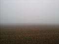
This hash is only 6 KM from my office and so I just have to try. So I started on my bull at half past seven in the morning. It was quite foggy but that didn’t matter in the town. After I’ve crossed the river rhine I had to ride through the fields and now I had to stop several times because my glasses got so wet that I couldn’t see anything anymore. Nevertheless I came close the hashpoint at half past eight. It lays on a field spanning between two rivulets, the Landgraben and the Leimbach.(as Lord Vetinari mentioned before). I stood near the Landgraben in the south and the hash was 150 m away near the Leimbach in the northern part of the field (I could hardly look that far because of the fog).
I drove some 200 m further along the field to find a better way through it (or along the edge of it), but I didn’t reach the end of it and the only thing I found was a tracktor-track which seemed to be a little bit less muddy. To my surprise the ground proved to be much harder than it looked and so I reached the hashpoint pretty fast and quite clean (or at least with only a little mud at my shoes).
I took some pictures of the fog, returned to my bull and continued my ride to my office. Unfortunatly I didn't left a mark. I didn't expect any other hasher today. I hope I'll earn from that (and maybe even announce my visits.)
To Lord Vetinari: I hope you keep on hashing and we'll meet one time.
Photos
Lord Vetinaris gallery
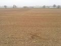
The hash's location. No treasure hidden here, though.
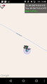
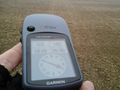
Screenshot of Proof
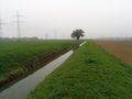
Looking west to where I came from. Stream in the picture is the Leimbach.
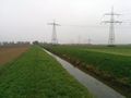
Looking east with a transformation station visible on the right

The happy geohasher
Myriads of flies near a tree
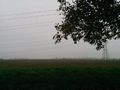
Parking spot between autumn trees


DODOs gallery
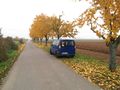
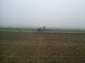
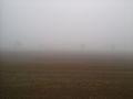
early morning view in direction of the hash
142 m into the field (in the background what I call a tractor track)
view to the bull (not from the hash but from the way to it)
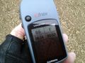
proof
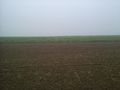
view to the north

the hasher
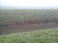
the Leimbach
view to the south (bull is in that direction but you can't see it)


Achievements
DODO earned the Land geohash achievement
|
DODO earned the Consecutive geohash achievement
|
Lord_Vetinari earned the Land geohash achievement
|